Scotia, South Carolina

Last updated

Scotia, South Carolina
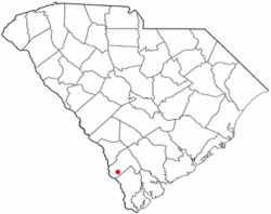
SCMap-doton-Scotia.PNG
Location of Scotia, South Carolina
Coordinates: 32°40′53″N81°14′50″W / 32.68139°N 81.24722°W / 32.68139; -81.24722
Country United States
State South Carolina
County Hampton
Area
[1]
  Total3.17 sq mi (8.20 km2)
  Land3.17 sq mi (8.20 km2)
  Water0.00 sq mi (0.00 km2)
Elevation
95 ft (29 m)
Population
 (2020) [2]
  Total158
  Density49.92/sq mi (19.28/km2)
Time zone UTC-5 (Eastern (EST))
  Summer (DST) UTC-4 (EDT)
ZIP code
29939
Area code(s) 803, 839
FIPS code 45-64465 [3]
GNIS feature ID1226451 [4]

Scotia is a town in Hampton County, South Carolina, United States. The population was 215 at the 2010 census. [5]

Contents

Geography

Scotia is located in southwestern Hampton County at 32°40′53″N81°14′50″W / 32.68139°N 81.24722°W / 32.68139; -81.24722 (32.681501, -81.247119). [6] U.S. Route 321 (Columbia Highway) passes through the center of town, leading north 5 miles (8 km) to Estill and south the same distance to Garnett. South Carolina Highway 333 runs east from Scotia 3 miles (5 km) to Furman. Hampton, the county seat, is 17 miles (27 km) northeast of Scotia.

According to the United States Census Bureau, the town has a total area of 3.2 square miles (8.2 km2), all land. [5]

Demographics

Historical population
CensusPop.Note
1910 189
1920 26942.3%
1930 32420.4%
1940 238−26.5%
1950 226−5.0%
1960 102−54.9%
1970 64−37.3%
1980 7212.5%
1990 182152.8%
2000 22724.7%
2010 215−5.3%
2020 158−26.5%
U.S. Decennial Census [7] [2]

As of the census [3] of 2000, there were 227 people, 86 households, and 63 families residing in the town. The population density was 71.3 inhabitants per square mile (27.5/km2). There were 99 housing units at an average density of 31.1 per square mile (12.0/km2). The racial makeup of the town was 26.43% White and 73.57% African American. Hispanic or Latino of any race were 2.20% of the population.

There were 86 households, out of which 34.9% had children under the age of 18 living with them, 48.8% were married couples living together, 16.3% had a female householder with no husband present, and 26.7% were non-families. 25.6% of all households were made up of individuals, and 11.6% had someone living alone who was 65 years of age or older. The average household size was 2.64 and the average family size was 3.14.

In the town, the population was spread out, with 29.5% under the age of 18, 6.6% from 18 to 24, 24.7% from 25 to 44, 24.7% from 45 to 64, and 14.5% who were 65 years of age or older. The median age was 39 years. For every 100 females, there were 99.1 males. For every 100 females age 18 and over, there were 86.0 males.

The median income for a household in the town was $22,292, and the median income for a family was $33,250. Males had a median income of $22,250 versus $22,917 for females. The per capita income for the town was $13,202. About 23.1% of families and 25.1% of the population were below the poverty line, including 27.0% of those under the age of eighteen and 21.7% of those 65 or over.
Related Research Articles

<span class="mw-page-title-main">Hampton County, South Carolina</span> County in South Carolina, United States

Hampton County is a rural county located in the U.S. state of South Carolina. As of the 2020 census, the population was 18,561. Its county seat is Hampton. It was named for Confederate Civil War general Wade Hampton, who in the late 1870s, with the ending of Reconstruction, was elected as governor of South Carolina.

<span class="mw-page-title-main">Myrtlewood, Alabama</span> Town in Alabama, United States

Myrtlewood is a town in Marengo County, Alabama, United States. At the 2020 census the population was 70, down from 130 in 2010.

<span class="mw-page-title-main">Harrell, Arkansas</span> Town in Arkansas, United States

Harrell is a town in Calhoun County, Arkansas, United States. The population was 254 at the 2010 census. It is part of the Camden Micropolitan Statistical Area.

<span class="mw-page-title-main">Massac, Kentucky</span> Census-designated place in Kentucky, United States

Massac is a census-designated place (CDP) in McCracken County, Kentucky, United States. The population was 4,635 at the 2020 census. It is part of the Paducah, KY-IL Metropolitan Statistical Area.

<span class="mw-page-title-main">Fairfax, South Carolina</span> Town in South Carolina, United States

Fairfax is a town in Allendale and Hampton counties, South Carolina, United States. The population was 2,025 at the 2010 census, a decline of over one-third of its population of 3,206 from 2000.

Ulmer is a town in Allendale County, South Carolina, United States. The population was 65 at the 2020 census.

<span class="mw-page-title-main">Elko, South Carolina</span> Town in South Carolina, United States

Elko is a town in Barnwell County, South Carolina, United States. According to the 2010 census the population was 193.

<span class="mw-page-title-main">Winnsboro Mills, South Carolina</span> Census-designated place in South Carolina, United States

Winnsboro Mills is an unincorporated community and census-designated place (CDP) in Fairfield County, South Carolina, United States. The population was 1,898 at the 2010 census, down from 2,263 at the 2000 census. It is part of the Columbia, South Carolina Metropolitan Statistical Area.

Wade Hampton is a census-designated place (CDP) in Greenville County, South Carolina, United States. The population was 20,622 at the 2010 census. It is named for American Civil War general and South Carolina governor Wade Hampton.

<span class="mw-page-title-main">Brunson, South Carolina</span> Town in South Carolina, United States

Brunson is a town in Hampton County, South Carolina, United States. The population was 554 at the 2010 census.

<span class="mw-page-title-main">Furman, South Carolina</span> Town in South Carolina, United States

Furman is a town in Hampton County, South Carolina, United States. The population was 224 at the 2020 census, down from 239 at the 2010 census. It is not to be confused with Furman University, which is in Greenville, South Carolina.

<span class="mw-page-title-main">Gifford, South Carolina</span> Town in South Carolina, United States

Gifford is a town in Hampton County, South Carolina, United States. The population was 288 at the 2010 census, down from 370 at the 2000 census.

<span class="mw-page-title-main">Hampton, South Carolina</span> Town in South Carolina, United States

Hampton is a town in Hampton County, South Carolina, United States. The population was 2,808 at the 2010 census. It is the county seat of Hampton County. The town and the county are named after Wade Hampton III, a Confederate general in the Civil War.

<span class="mw-page-title-main">Luray, South Carolina</span> Town in South Carolina, United States

Luray is a town in Hampton County, South Carolina, United States. The population was 127 at the 2010 census.

Varnville is a town in Hampton County, South Carolina, United States. The population was 2,162 as of the 2010 census. Varnville forms a twin town with Hampton, the county seat; the two towns often share civic and cultural events.

<span class="mw-page-title-main">Carlisle, South Carolina</span> Town in South Carolina, United States

Carlisle is a town in Union County, South Carolina, United States. The population was 436 according to the 2010 United States Census.

<span class="mw-page-title-main">Virgilina, Virginia</span> Town in Virginia, United States

Virgilina is a town in Halifax County, Virginia, United States. The population was 154 at the 2010 census. Virgilina was once a copper mining town. It was a stop on the Atlantic and Danville Railway as recently as the 1950s. It is named "Virgilina" because it is located on the Virginia and North Carolina border.

<span class="mw-page-title-main">Fairview, West Virginia</span> Town in West Virginia, United States

Fairview is a town in Marion County, West Virginia, United States. The population was 374 at the 2020 census.

<span class="mw-page-title-main">Monetta, South Carolina</span> Town in South Carolina, United States of America

Monetta is a town in Aiken and Saluda counties, South Carolina, United States. The population was 236 at the 2010 census.

<span class="mw-page-title-main">Yemassee, South Carolina</span> Town in South Carolina, United States

Yemassee is a small Lowcountry town in Beaufort and Hampton counties in the U.S. state of South Carolina. The population was 1,027 at the 2010 census. Yemassee is near the borders of Colleton and Jasper counties. The town is divided by the county line between Beaufort and Hampton counties, which follows the roadbed of the CSX railroad. Most of the town's population presently lies within Hampton County. As defined by the U.S. Census Bureau, the Beaufort County portion of Yemassee is included within the Hilton Head Island-Bluffton-Beaufort, SC Metropolitan Statistical Area. Yemassee hosts one of the few commercial breeding facilities of non-human primates in the entire United States, Alpha Genesis, Inc., which serves as a major employer for the town. Also, the Frank Lloyd Wright-designed Auldbrass Plantation house and outbuildings lie just outside the town limits of Yemassee.

References

  1. "ArcGIS REST Services Directory". United States Census Bureau. Retrieved October 15, 2022.
  2. 1 2 "Census Population API". United States Census Bureau. Retrieved October 15, 2022.
  3. 1 2 "U.S. Census website". United States Census Bureau . Retrieved January 31, 2008.
  4. "US Board on Geographic Names". United States Geological Survey. October 25, 2007. Retrieved January 31, 2008.
  5. 1 2 "Geographic Identifiers: 2010 Census Summary File 1 (G001): Scotia town, South Carolina". American Factfinder. U.S. Census Bureau. Archived from the original on February 13, 2020. Retrieved January 24, 2018.
  6. "US Gazetteer files: 2010, 2000, and 1990". United States Census Bureau. February 12, 2011. Retrieved April 23, 2011.
  7. "Census of Population and Housing". Census.gov. Retrieved June 4, 2015.