
U.S. Route 176 is a spur of US 76 in the U.S. states of North Carolina and South Carolina. The U.S. Highway runs 237.98 miles (382.99 km) from US 25 Business and North Carolina Highway 225 in Hendersonville, North Carolina, east to US 52 in Goose Creek, South Carolina. US 176 serves the transition region between the Blue Ridge Mountains and Foothills of Western North Carolina and the Upstate, Midlands, and Lowcountry regions of South Carolina. The highway passes through and connects Spartanburg, one of two major cities in the Upstate, and Columbia, the South Carolina state capital and central city of the Midlands. US 176 parallels and serves as a secondary highway to Interstate 26 (I-26) except for between Spartanburg and Columbia, where the U.S. Highway deviates from the I-26 corridor to serve Union.

South Carolina Highway 5 (SC 5) is a primary state highway in the U.S. state of South Carolina. The highway connects the cities of Rock Hill, York and Blacksburg.

South Carolina Highway 9 is a 258.3-mile-long (416 km) major state highway in the U.S. state of South Carolina. The route runs from North Myrtle Beach to the North Carolina border upstate. The road is currently the longest state highway in South Carolina. It is signed as a north–south highway though overall it runs in an east–west direction.

South Carolina Highway 34 (SC 34) is a primary state highway in the U.S. state of South Carolina. As one of the longer state highways, it traverses the state east-west from Greenwood to Dillon, connecting the cities of Newberry, Winnsboro, Camden, Bishopville and Darlington.

North Carolina Highway 200 (NC 200) is a primary state highway in the U.S. state of North Carolina. The highway runs north–south from the South Carolina state line near the community of JAARS, to US 601 near Concord.
U.S. Route 76 (US 76) is an east–west U.S. highway in the U.S. state of South Carolina. Being one of the longest highways in the state, it connects the cities of Anderson, Columbia, Sumter and Florence.
U.S. Route 301 (US 301) runs north–south from the Savannah River southwest of Allendale to Hamer approaching the South of the Border roadside attraction complex.
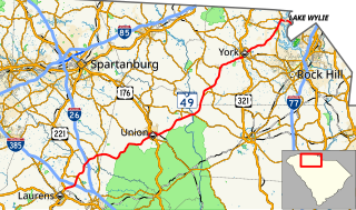
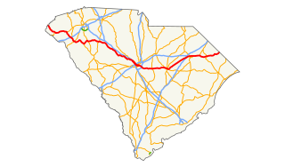
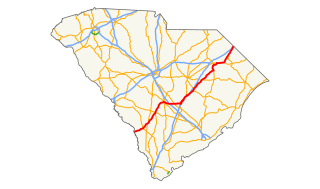
South Carolina Highway 49 (SC 49) is a primary state highway in the U.S. state of South Carolina. It is signed as a north–south highway, though it travels in a southwesterly-northeasterly direction, from Watts Mills to the North Carolina state line in Lake Wylie.
South Carolina Highway 265 (SC 265) is a primary state highway in the U.S. state of South Carolina. It serves to connect Jefferson with the cities of Kershaw and Chesterfield.

South Carolina Highway 262 (SC 262) is a primary state highway in the U.S. state of South Carolina. It serves primarily as the southern border of Fort Jackson.

South Carolina Highway 3 (SC 3) is a state highway in the southern part of the U.S. state of South Carolina. The highway runs 95.8 miles (154.2 km) in a C-shape from a point approximately 11 miles (18 km) southeast of Varnville northwest and north to Barnwell, and then northeast to Swansea.
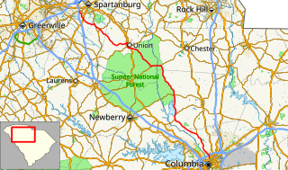
South Carolina Highway 215 (SC 215) is a primary state highway in the U.S. state of South Carolina. It serves as an alternate route to Union from either Columbia or Spartanburg.
South Carolina Highway 403 (SC 403) is a primary state highway in the U.S. state of South Carolina. It serves the town of Timmonsville and the surrounding rural area with the cities of Lake City and Hartsville.
South Carolina Highway 641 (SC 641) is a primary state highway in the U.S. state of South Carolina. It provides the city of Allendale with a direct route to Charleston, via SC 64 and U.S. Route 17 (US 17). It also serves access to Rivers Bridge State Park.

South Carolina Highway 70 (SC 70) is a primary state highway in the U.S. state of South Carolina. It connects the cities of Barnwell and Denmark with Orangeburg via U.S. Route 301 (US 301) and US 601.
South Carolina Highway 462 (SC 462) is a primary state highway in the U.S. state of South Carolina. It serves as a circuitous routing through northern and eastern Jasper County.

South Carolina Highway 20 (SC 20) is a primary state highway in the U.S. state of South Carolina. The highway connects the cities of Abbeville, Belton, Williamston and Greenville. The 53-mile-long (85 km) highway is signed as a west-east highway though it physically runs south-to-north.
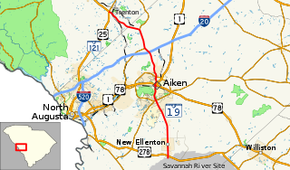
South Carolina Highway 19 (SC 19) is a primary state highway in the U.S. state of South Carolina. It connects Aiken directly with the Savannah River Site and Edgefield via U.S. Route 25 (US 25).
South Carolina Highway 322 (SC 322) is a 17.7-mile-long (28.5 km) state highway in the U.S. state of South Carolina. The highway travels through mostly rural areas of Orangeburg County.
South Carolina Highway 692 (SC 692) is a 9.3-mile-long (15.0 km) state highway in the U.S. state of South Carolina. The highway connects mostly rural areas of Orangeburg and Lexington counties with Swansea. It runs generally north and south though it is officially designated as an east-west highway with its western terminus at U.S. Route 321 (US 321) in Swansea and its eastern terminus at US 178 east of North.


