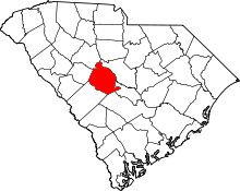
[3] Name on the Register [4] Image Date listed [5] Location City or town Description 1 Ballentine-Shealy House Ballentine-Shealy House November 22, 1983 (# 83003858 South Carolina Highway 1323 34°06′17″N 81°22′55″W / 34.104722°N 81.381944°W / 34.104722; -81.381944 (Ballentine-Shealy House ) Lexington Late 18th- or early 19th- century log home, sheathed in weatherboard; with ancillary buildings. 2 Bank of Western Carolina Bank of Western Carolina November 22, 1983 (# 83003860 126 Main St. 33°58′53″N 81°14′12″W / 33.981389°N 81.236667°W / 33.981389; -81.236667 (Bank of Western Carolina ) Lexington 3 D. D. D. Barr House D. D. D. Barr House November 22, 1983 (# 83003866 Off South Carolina Highway 245 33°56′12″N 81°31′38″W / 33.936667°N 81.527222°W / 33.936667; -81.527222 (D. D. D. Barr House ) Batesburg-Leesville 4 Batesburg Commercial Historic District Batesburg Commercial Historic District July 6, 1982 (# 82003875 Granite, Oak, Pine, and Church Sts., and Rutland and N. Railroad Aves. 33°54′25″N 81°32′54″W / 33.906944°N 81.548333°W / 33.906944; -81.548333 (Batesburg Commercial Historic District ) Batesburg-Leesville 5 W. Q. M. Berly House W. Q. M. Berly House November 22, 1983 (# 83003870 122 Berly St. 33°59′14″N 81°14′30″W / 33.987222°N 81.241667°W / 33.987222; -81.241667 (W. Q. M. Berly House ) Lexington 6 William Berly House William Berly House November 23, 1977 (# 77001230 121 Berly St. 33°59′14″N 81°14′29″W / 33.987222°N 81.241389°W / 33.987222; -81.241389 (William Berly House ) Lexington 7 Lemuel Boozer House Lemuel Boozer House August 16, 1977 (# 77001231 320 W. Main St. 33°59′06″N 81°14′32″W / 33.985°N 81.242222°W / 33.985; -81.242222 (Lemuel Boozer House ) Lexington 8 Simon Bouknight House Simon Bouknight House July 6, 1982 (# 82003876 Saluda Ave. 33°54′32″N 81°33′10″W / 33.908889°N 81.552778°W / 33.908889; -81.552778 (Simon Bouknight House ) Batesburg-Leesville 9 Cartledge House Cartledge House July 6, 1982 (# 82003879 305 Saluda Ave. 33°54′31″N 81°33′08″W / 33.908611°N 81.552222°W / 33.908611; -81.552222 (Cartledge House ) Batesburg-Leesville 10 William J. Cayce House William J. Cayce House April 16, 1975 (# 75001703 517 Holland Ave. 33°58′31″N 81°03′13″W / 33.975278°N 81.053611°W / 33.975278; -81.053611 (William J. Cayce House ) Cayce 11 Cedar Grove Lutheran Church Cedar Grove Lutheran Church November 17, 2010 (# 10000922 1220 Cedar Grove Rd. 33°59′13″N 81°27′35″W / 33.986944°N 81.459722°W / 33.986944; -81.459722 (Cedar Grove Lutheran Church ) Batesburg-Leesville 12 Chapin Commercial Historic District Upload image October 7, 2019 (# 100004495 Bounded by Lexington Ave., Beaufort St., Chapin Rd., and the rear lots along Columbia Ave. 34°09′59″N 81°20′58″W / 34.1665°N 81.3494°W / 34.1665; -81.3494 (Chapin Commercial Historic District ) Chapin 13 Church Street Historic District Church Street Historic District July 6, 1982 (# 82003884 Church St. 33°55′09″N 81°30′24″W / 33.919167°N 81.506667°W / 33.919167; -81.506667 (Church Street Historic District ) Batesburg-Leesville 14 Colonial-Hites Company Colonial-Hites Company May 24, 2018 (# 100002526 228 N Parson St. 33°59′18″N 81°04′39″W / 33.9884°N 81.0774°W / 33.9884; -81.0774 (Colonial-Hites Company ) West Columbia 15 "Congarees" Site Upload image December 31, 1974 (# 74002261 Address Restricted Cayce 16 C.E. Corley House C.E. Corley House November 22, 1983 (# 83003872 808 S. Lake Dr. 33°58′00″N 81°14′02″W / 33.966667°N 81.233889°W / 33.966667; -81.233889 (C.E. Corley House ) Lexington 17 Jacob Wingard Dreher House Jacob Wingard Dreher House November 22, 1983 (# 83003875 Off South Carolina Highway 6 34°04′13″N 81°14′27″W / 34.070278°N 81.240833°W / 34.070278; -81.240833 (Jacob Wingard Dreher House ) Irmo 18 Broadus Edwards House Broadus Edwards House July 6, 1982 (# 82003877 12 Peachtree St. 33°54′12″N 81°33′03″W / 33.903333°N 81.550833°W / 33.903333; -81.550833 (Broadus Edwards House ) Batesburg-Leesville 19 Fox House Fox House July 1, 1970 (# 70000893 232 Fox St. 33°59′14″N 81°14′23″W / 33.987222°N 81.239722°W / 33.987222; -81.239722 (Fox House ) Lexington 20 Gervais Street Bridge Gervais Street Bridge November 25, 1980 (# 80003676 Spans the Congaree River 33°59′47″N 81°02′55″W / 33.996389°N 81.048611°W / 33.996389; -81.048611 (Gervais Street Bridge ) West Columbia Extends into Columbia in Richland County 21 David Jefferson Griffith House Upload image November 22, 1983 (# 83003879 Address Restricted Gilbert 22 Guignard Brick Works Guignard Brick Works February 13, 1995 (# 95000019 100 Granby Crossing at Knox Abbot Dr. 33°59′16″N 81°03′02″W / 33.987778°N 81.050556°W / 33.987778; -81.050556 (Guignard Brick Works ) Cayce 23 Gunter-Summers House Gunter-Summers House November 10, 1987 (# 87001988 841 Center St. 33°59′24″N 81°04′00″W / 33.99°N 81.066667°W / 33.99; -81.066667 (Gunter-Summers House ) Lexington 24 Hampton Hendrix Office Upload image July 6, 1982 (# 82003885 Leesville Ave. 33°55′05″N 81°30′50″W / 33.918056°N 81.513889°W / 33.918056; -81.513889 (Hampton Hendrix Office ) Batesburg-Leesville 25 James Harman Building James Harman Building November 22, 1983 (# 83003903 Gantt St. 33°58′55″N 81°14′09″W / 33.981944°N 81.235833°W / 33.981944; -81.235833 (James Harman Building ) Lexington 26 Hartley House Hartley House July 9, 1982 (# 82003878 305 E. Columbia Ave. 33°54′23″N 81°32′27″W / 33.906389°N 81.540833°W / 33.906389; -81.540833 (Hartley House ) Batesburg-Leesville 27 Ernest L. Hazelius House Ernest L. Hazelius House May 11, 1973 (# 73001717 Fox St. 33°59′14″N 81°14′26″W / 33.987222°N 81.240556°W / 33.987222; -81.240556 (Ernest L. Hazelius House ) Lexington 28 Henry Franklin Hendrix House Henry Franklin Hendrix House July 6, 1982 (# 82003886 Hendrix Heights Plantation 33°54′56″N 81°31′33″W / 33.915556°N 81.525833°W / 33.915556; -81.525833 (Henry Franklin Hendrix House ) Batesburg-Leesville 29 John Solomon Hendrix House John Solomon Hendrix House November 22, 1983 (# 83003904 Old Cherokee Rd. 34°00′14″N 81°17′09″W / 34.003889°N 81.285833°W / 34.003889; -81.285833 (John Solomon Hendrix House ) Lexington 30 Thomas Galbraith Herbert House Thomas Galbraith Herbert House July 6, 1982 (# 82003887 506 Trotter St. 33°55′32″N 81°31′05″W / 33.925556°N 81.518056°W / 33.925556; -81.518056 (Thomas Galbraith Herbert House ) Batesburg-Leesville 31 John Jacob Hite Farm Upload image November 22, 1983 (# 83003908 Address Restricted Lexington 32 J.B. Holman House J.B. Holman House July 6, 1982 (# 82003888 N. Peachtree St. 33°54′18″N 81°33′07″W / 33.905°N 81.551944°W / 33.905; -81.551944 (J.B. Holman House ) Batesburg-Leesville 33 Home National Bank Home National Bank November 22, 1983 (# 83003909 Main St. and North Lake Dr. 33°58′52″N 81°14′09″W / 33.981111°N 81.235833°W / 33.981111; -81.235833 (Home National Bank ) Lexington 34 A.C. Jones House A.C. Jones House July 6, 1982 (# 82003880 104 Fair Ave. 33°54′22″N 81°32′33″W / 33.906111°N 81.5425°W / 33.906111; -81.5425 (A.C. Jones House ) Batesburg-Leesville 35 Lakeview School Lakeview School January 31, 2023 (# 100008590 1218 Batchelor St. 33°59′32″N 81°04′35″W / 33.9921°N 81.0765°W / 33.9921; -81.0765 (Lakeview School ) West Columbia 36 Leesville College Historic District Leesville College Historic District July 6, 1982 (# 82003889 Railroad Ave. and College, Peachtree, King, and Lee Sts. 33°55′14″N 81°30′55″W / 33.920556°N 81.515278°W / 33.920556; -81.515278 (Leesville College Historic District ) Batesburg-Leesville 37 Lexington County Courthouse Lexington County Courthouse April 21, 2014 (# 14000164 139 E. Main St. 33°58′53″N 81°14′11″W / 33.9814614°N 81.2363456°W / 33.9814614; -81.2363456 (Lexington County Courthouse ) Lexington 38 Henry Lybrand Farm Upload image November 22, 1983 (# 83003911 Address Restricted Lexington 39 Manning Archeological Site Upload image December 14, 1978 (# 78002522 Address Restricted Cayce 40 Maj. Henry A. Meetze House Maj. Henry A. Meetze House July 13, 1979 (# 79002387 South of Lexington at 723 S. Lake Dr. 33°58′06″N 81°14′04″W / 33.968333°N 81.234444°W / 33.968333; -81.234444 (Maj. Henry A. Meetze House ) Lexington 41 Crowell Mitchell House Upload image July 6, 1982 (# 82003890 Church St. 33°55′02″N 81°30′40″W / 33.917222°N 81.511111°W / 33.917222; -81.511111 (Crowell Mitchell House ) Batesburg-Leesville 42 McKendree Mitchell House McKendree Mitchell House July 6, 1982 (# 82003881 310 Saluda Ave. 33°54′35″N 81°33′09″W / 33.909722°N 81.5525°W / 33.909722; -81.5525 (McKendree Mitchell House ) Batesburg-Leesville 43 Mitchell-Shealy House Mitchell-Shealy House July 6, 1982 (# 82003891 419 W. Church St. 33°54′39″N 81°31′37″W / 33.910833°N 81.526944°W / 33.910833; -81.526944 (Mitchell-Shealy House ) Batesburg-Leesville 44 Mount Hebron Temperance Hall Mount Hebron Temperance Hall November 24, 1980 (# 80003677 3041 Leaphart Rd. 33°59′58″N 81°07′29″W / 33.999444°N 81.124722°W / 33.999444; -81.124722 (Mount Hebron Temperance Hall ) West Columbia 45 Music Hall Evangelical Lutheran Church Upload image November 22, 1983 (# 83003913 Address Restricted Gilbert 46 New Brookland Historic District New Brookland Historic District October 10, 1978 (# 78002524 Roughly bounded by Alexander Rd. and Augusta, State, Spring, and Meeting Sts. 33°59′34″N 81°03′17″W / 33.992778°N 81.054722°W / 33.992778; -81.054722 (New Brookland Historic District ) West Columbia 47 Old Batesburg Grade School Old Batesburg Grade School May 27, 1983 (# 83002201 306 E. Columbia Ave 33°54′23″N 81°32′23″W / 33.906389°N 81.539722°W / 33.906389; -81.539722 (Old Batesburg Grade School ) Batesburg-Leesville 48 Old Batesburg-Leesville High School Old Batesburg-Leesville High School July 6, 1982 (# 82003893 Columbia Ave at Shealy Rd 33°54′39″N 81°32′24″W / 33.910833°N 81.54°W / 33.910833; -81.54 (Old Batesburg-Leesville High School ) Batesburg-Leesville 49 Peter M. and Alice Oliver House Peter M. and Alice Oliver House January 6, 2023 (# 100008531 295 West 1st St. 33°44′20″N 81°06′08″W / 33.73885°N 81.1022°W / 33.73885; -81.1022 (Peter M. and Alice Oliver House ) Swansea 50 Charlton Rauch House Charlton Rauch House November 22, 1983 (# 83003914 Main and Cedar Sts. 33°59′03″N 81°14′26″W / 33.984167°N 81.240556°W / 33.984167; -81.240556 (Charlton Rauch House ) Lexington 51 David Rawl House David Rawl House November 22, 1983 (# 83003915 201 W. Main St. 33°58′59″N 81°14′21″W / 33.983056°N 81.239167°W / 33.983056; -81.239167 (David Rawl House ) Lexington 52 John Jacob Rawl House John Jacob Rawl House July 6, 1982 (# 82003882 Line St. 33°54′33″N 81°32′53″W / 33.909167°N 81.548056°W / 33.909167; -81.548056 (John Jacob Rawl House ) Batesburg-Leesville 53 Rawl-Couch House Rawl-Couch House July 6, 1982 (# 82003883 22 Short St. 33°54′29″N 81°33′14″W / 33.908056°N 81.553889°W / 33.908056; -81.553889 (Rawl-Couch House ) Batesburg-Leesville 54 Robinson-Hiller House Robinson-Hiller House May 18, 1998 (# 98000420 113 Virginia St. 34°09′57″N 81°21′20″W / 34.165833°N 81.355556°W / 34.165833; -81.355556 (Robinson-Hiller House ) Chapin 55 St. Michael's Evangelical Lutheran Church Upload image July 24, 2023 (# 83004664 North of State Road 38 34°04′23″N 81°14′28″W / 34.0731°N 81.2410°W / 34.0731; -81.2410 (St. Michael's Evangelical Lutheran Church ) Irmo vicinity 56 Saluda Factory Historic District Upload image May 25, 1973 (# 73001718 Along the Saluda River southeast of the junction of Interstates 26 and 126 34°01′05″N 81°05′13″W / 34.018056°N 81.086944°W / 34.018056; -81.086944 (Saluda Factory Historic District ) West Columbia 57 SAM Site Upload image December 6, 1978 (# 78002523 Address Restricted Cayce A South Appalachian Mississippian site 58 Simmons-Harth House Simmons-Harth House November 22, 1983 (# 83003916 102 Gantt St. 33°58′54″N 81°14′09″W / 33.981667°N 81.235833°W / 33.981667; -81.235833 (Simmons-Harth House ) Lexington 59 Southern Railway Depot Southern Railway Depot May 27, 1983 (# 83002202 Southeast corner of Perry and Wilson Sts. 33°54′22″N 81°32′33″W / 33.906111°N 81.5425°W / 33.906111; -81.5425 (Southern Railway Depot ) Batesburg-Leesville 60 James Stewart House Upload image November 22, 1983 (# 83003917 Address Restricted Lexington 61 Still Hopes Still Hopes November 22, 1983 (# 83003921 Off 7th St. 33°59′08″N 81°03′44″W / 33.985556°N 81.062222°W / 33.985556; -81.062222 (Still Hopes ) Cayce Also known as the G. A. Guignard House 62 Taylor Site Upload image November 21, 1974 (# 74001864 Address Restricted Cayce 63 Vastine Wessinger House Upload image November 22, 1983 (# 83003923 Address Restricted Lexington 64 Rev. Frank Yarborough House Rev. Frank Yarborough House July 6, 1982 (# 82003892 810 Bernard St. 33°55′30″N 81°30′57″W / 33.925°N 81.515833°W / 33.925; -81.515833 (Rev. Frank Yarborough House ) Batesburg-Leesville