Chapin, South Carolina

Last updated

Chapin, South Carolina
Chapin-Town-Hall-sc.jpg
Town Hall
Nicknames: 
"The Capital of Lake Murray", "Home of the Eagles"
Motto: 
"Fish Away"
SCMap-doton-Chapin.PNG
Location of Chapin, South Carolina
Coordinates: 34°9′57″N81°20′50″W / 34.16583°N 81.34722°W / 34.16583; -81.34722
Country United States
State South Carolina
County Lexington
Government
  MayorAlbert Koon
Area
[1]
  Total1.99 sq mi (5.16 km2)
  Land1.98 sq mi (5.13 km2)
  Water0.01 sq mi (0.03 km2)
Elevation
[2]
463 ft (141 m)
Population
 (2020) [3]
  Total1,809
  Density913.64/sq mi (352.81/km2)
Time zone UTC-5 (Eastern (EST))
  Summer (DST) UTC-4 (EDT)
ZIP code
29036
Area code(s) 803, 839
FIPS code 45-13150 [4]
GNIS feature ID1231155 [2]
Demonym Chapinite
Website www.chapinsc.com

Chapin, popularly known as the "Capital of Lake Murray", is a small lake town located at the northern tip of Lexington County, South Carolina, United States. Lake Murray separates Chapin from the rest of Lexington County. The population of Chapin was 1,445 according to the 2010 census, [5] and an estimated 1,633 in 2019.

Contents

Chapin is located approximately 24 miles (39 km) northwest of Columbia, and many people commute there for work; however, the town is considered fringe rural by the US postal service.[ citation needed ]

The town government is set up in the mayor-council form, and the current mayor is Albert Koon. Chapin has four public schools in the area; the first Chapin school was built in 1924. Lake Murray is the main attraction to Chapin and provides boaters with water-related recreation.

History

Chapin is named after Martin Chapin in 1889. After Chapin and Laura Anne Benjamin were married on June 16, 1850, the couple moved down South because of Martin's health (a lung condition). The Chapins were living in Columbia when Martin's doctor suggested he to move to the Piney Woods area. He bought property in this area, and over the years Chapin bought 4,218 acres (1,707 ha). He built a home in Piney Woods and later a hotel in the 1880s along the new rail line that ran from Columbia to Laurens, the Columbia, Newberry and Laurens Railroad. The railroad provided a way to trade and transport goods to the capital city. Cotton and the lumber industry were flourishing with the railroad providing transportation. After Martin's death on August 31, 1894, Laura Chapin sold their home and moved into the Chapin hotel. [6]

On March 28, 1907, Job S. Wessinger, P.M. Frick, and J. S. Honeycut founded the Bank of Chapin. One year later the building for the bank was built. The bank prospered with help from the railroad. [7]

During World War I, Chapin was doing well economically. The price of cotton had risen and the farmers were making plenty of money. As a result, the Bank of Chapin was also thriving during this time. The first high school was built in 1924. [8]

Slowly the businesses in Chapin were starting to experience hard times nearing the 1930s. On Thursday, October 15, 1931, the Bank of Chapin did not open, and like other banks around the world, the bank would not allow customers to withdraw their money. Anybody who had money saved in the bank lost that money due to the crash of the stock market, later known as the start of the Great Depression. Another disaster to hit Chapin was the building of the dam on the Saluda River that would result in the building of a lake. This lake would take over most of the Chapin families’ farms and homesteads. The building of the dam was started in 1927. [9]

In the midst of the Great Depression Chapin started a recreational team sport of baseball. In 1935, the Dutch Fork League was formed where Chapin had its own team. This team helped the unemployed men occupy their time during these difficult times. These baseball games attracted thousands of people. [10]

During the 1940s Chapin grew through improvements to the school and opening new businesses. One new business that came to Chapin were filling stations. The next business was a cabinet shop called E. A. Frick and Son. Chapin also built paved roads, a baseball field and established the public library. In 1950 the first post office building was constructed, along with new telephone services. [6]

The 1960s were about new and better services. Garbage collection was an issue in the '60s, so the town government bought land and built a landfill. Transportation was the next service provided by access to an interstate highway. On September 7, 1960 a section of Interstate 26 was opened between Columbia and Pomaria. The interstate made Chapin more accessible. [11] Streets in town were also improved. Another improvement of the '60s was the new water system. In 1965 a volunteer fire department was organized, and in 1966 the town had its first ambulance. Chapin also started growing in population as more people moved to the town in the 1960s. [12]

During the 1970s new schools were built. Chapin football became a community event, and the school football team won state championships in 1973 and 1974. Also in the '70s churches in the town of Chapin were growing by establishment of Chapin Baptist Church, St. Francis of Assisi Episcopal Church, Our Lady of the Lake Catholic Church, and Lake Murray Presbyterian Church. [13]

The Robinson-Hiller House was listed on the U.S. National Register of Historic Places in 1998, and the Chapin Commercial Historic District was added in 2019. [14]

Geography

Chapin is located in the northern corner of Lexington County at 34°9′57″N81°20′50″W / 34.16583°N 81.34722°W / 34.16583; -81.34722 (34.165783, -81.347260). [15]

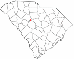
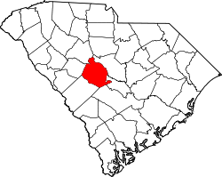
According to the United States Census Bureau, the town has a total area of 2.0 square miles (5.2 km2), of which 0.01 square miles (0.03 km2), or 0.53%, are water. [16]

While Chapin is a part of Lexington County, the creation of Lake Murray by the Dreher Shoals Dam cut Chapin off from the rest of the county by road, creating something of an exclave.

Demographics

Historical population
CensusPop.Note
1900 187
1910 34584.5%
1920 264−23.5%
1930 42962.5%
1940 311−27.5%
1950 3275.1%
1960 3589.5%
1970 342−4.5%
1980 311−9.1%
1990 282−9.3%
2000 628122.7%
2010 1,445130.1%
2020 1,80925.2%
U.S. Decennial Census [17] [3]

2000 census

According to the 2000 Census, the incorporated limits of the Town of Chapin had a population of 628. The census counted 249 occupied housing units within the town. Per capita income was $24,124. Median household income within the town limits was $48,750. [18]

2010 census

The 2010 Census recorded that Chapin has a population of 1,445 with 658 total housing units within town limits. [19]

2020 census

Chapin racial composition [20]
RaceNum.Perc.
White (non-Hispanic)1,39977.34%
Black or African American (non-Hispanic)1488.18%
Native American 40.22%
Asian 492.71%
Other/Mixed 754.15%
Hispanic or Latino 1347.41%

As of the 2020 United States census, there were 1,809 people, 768 households, and 524 families residing in the town.

Government

Chapin's mayor and the town council run for a four-year term. The council has chosen a Mayor-Council form of government. This means that the mayor has more majority status than council members. Chapin's town government is made up of three council members, a mayor pro tem, and a mayor. Currently the Mayor of Chapin is Albert Koon. The Mayor Pro Tem is Mike Clonts along with the council members who are Gregg White, Leland Teal. . [21]

History

In 1940 the mayor was S. J. Cannon. He served a one-year term along with officers W.W. Goza, H. E. Metts, Carl Shealy, and W. B. Fulmer. Other offices voted on during this election were town clerk and policeman. The next year, 1941, W. W. Goza was elected mayor and served until 1944. In 1944, J. L. Amick was elected mayor. Numerous others have served as mayor between J. L. Amick and Albert Koon. [22]

Education

History of local schools

The first school in Chapin was located in the Chapin house. In 1924 a high school was built out of concrete blocks and brick. In 1927 the school alma mater “Chapin, Dear Chapin” was composed by Helen Miller. This alma mater is the same one used at Chapin High School today. [23]

Chapin schools and churches were the center of life in town according to historian Addison Bostain. Chapin High School had 150 students enrolled in 1929 and the elementary school had 150 students. The school only housed 11 grades. [24]

Chapin High School had been built in separate parts since 1924 and by 1940 the high school still did not have a gym. The school auditorium was home to both the theater and a basketball court. The gymnasium was not built until 1952. The Chapin community built the gym for less than $30,000 dollars. [25]

The 12th grade was added to Chapin High School in 1948 as well as the first football team. The football team was a very expensive investment, so in 1952 the Irmo and Chapin High School football teams were combined. Together they were known as the Flying Dutchmen football team. The teams separated again, and Chapin has had its own team since 1959. [22]

In 1970 a new high school was built with much better facilities. The school had new labs, band, chorus, and physical educational areas. In addition to a new building, the Chapin football team became a powerhouse for football in state of South Carolina. Cecil Woolbright became Chapin High School's head football coach and athletic director in 1968. The Chapin High School Eagles won two state championships and three conference titles in three years. This happened in 1973, 74 and 75, along with a 30-game winning streak. [22] The Chapin High School's mascot is named Cecil the Eagle.

A new elementary school opened in August 1977. The school could house 840 children. [26]

Library

Chapin has a public library, a branch of the Lexington County Public Library. [27]

Churches

The first church established in Chapin was Mt. Horeb Lutheran Church in 1891. The Chapin Methodist Church was established in 1889, but was not within town limits until 1892. Again in 1892, Mt. Zion Baptist Church was started with an African American congregation. Another church for African Americans was St. John's AME church, which is older than Mt. Zion, but the date is unknown. [28] Much later in 1972 was the start of Chapin Baptist Church. Lake Murray Presbyterian Church was organized in 1974. Next to arrive in Chapin was St. Francis of Assisi Episcopal Church in 1977. Our Lady of the Lake Catholic Church was established in 1978. [29]

Attractions

Lake Murray

View of Lake Murray (120DPI)grayStateIcon.jpg
View of Lake Murray

Chapin is often referred to as the "capital of Lake Murray". On September 21, 1927, work on the dam for the Saluda River was started. The construction finished on June 30, 1930. [19] Chapin families who had lived on Chapin land for over 200 years had to sell and move to make room for the lake that was a result of the dam. The lake was to spread between Dutch Fork and Chapin, becoming 14 miles (23 km) wide and 40 miles (64 km) long. [24]

The earthen dam stands over 200 feet (61 m) tall and runs 1.5 miles (2.4 km) across. Lake Murray has over 500 miles (800 km) of shoreline and covers approximately 50,000 acres (200 km2). [19] The dam itself takes up 99 acres (40 ha). [30] The nearest arm of the lake reaches within 0.5 miles (0.80 km) of the town limits.

The dam on Lake Murray has been through many changes since it was originally built in 1927. In 1943 3 feet (0.91 m) were added to the dam's height to help flooding issues. Much later in the 1980s SCE&G added a sheet piling way on the lakeside of the highway again to help with flooding. This sheet piling way raised the height of the dam again.

The latest changes to the dam occurred in 2002 when the backup dam was built. The backup dam was built for more protection to withstand earthquakes. The backup dam is made of rock and concrete to withstand the weight of the water behind the dam if any damage were to occur to the existing dam. [31]

Lake Murray is not only used to provide electrical power for surrounding areas, it brings boating activities to the area. Lake Murray offers many different types of boating opportunities in addition to recreational areas. Today, the lake has recreational swimming, boating, skiing, fishing, and wake-boarding. The lake also holds fishing tournaments and is home to many kinds of wildlife. Lake Murray is known for its purple martins, striped bass, and great blue heron. [32]

Labor Day Festival

Chapin is home to the Chapin Labor Day Festival. The Chapin Labor Day Festival is held every year in the town of Chapin on Labor Day. The festival lasts for three days starting on the Saturday before Labor Day and ending on Labor Day. On Monday, the festival activities start off with a parade through town and often features local, state and sometimes national political candidates. The Chapin High School NJROTC also marches in the parade annually. After the parade there is a carnival, Chapin Idol, vendors, food, concerts, and a car show along the historic streets of downtown Chapin. [33]

Notable people

Related Research Articles

<span class="mw-page-title-main">Union County, South Carolina</span> County in South Carolina, United States

Union County is a county located in the U.S. state of South Carolina. As of the 2020 census, the population was 27,244. Its county seat is Union. The county was created in 1785.

<span class="mw-page-title-main">Lexington County, South Carolina</span> County in South Carolina, United States

Lexington County is a county located in the U.S. state of South Carolina. As of the 2020 census, the population was 293,991. Its county seat and largest town is Lexington. The county was chartered in 1785 and was named in commemoration of Lexington, Massachusetts, the site of the Battle of Lexington in the American Revolutionary War. Lexington County is the sixth-largest county in South Carolina by population and is part of the Columbia, SC Metropolitan Statistical Area. It is located in the Midlands region of South Carolina.

<span class="mw-page-title-main">Connersville, Indiana</span> City in Indiana, United States

Connersville is a city in Fayette County, east central Indiana, United States, 66 miles (106 km) east by southeast of Indianapolis. The population was 13,481 at the 2010 census. The city is the county seat of and the largest and only incorporated town in Fayette County. The city is in the center of a large rural area of east central Indiana; the nearest significant city is Richmond, 26 miles (42 km) to the northeast by road. Connersville is home to the county's only high school. The economy is supported by local manufacturing, retail, and healthcare. Employment and population have been declining since the 1960s and it is among the poorest areas of the state in median household income and other economic measures.

<span class="mw-page-title-main">Mount Sterling, Kentucky</span> City in Kentucky, United States

Mount Sterling, often written as Mt. Sterling, is a home rule-class city in Montgomery County, Kentucky, United States. The population was 7,558 as of the 2020 census, up from 6,895 in 2010. It is the county seat of Montgomery County and the principal city of the Mount Sterling micropolitan area.

<span class="mw-page-title-main">Chicopee, Massachusetts</span> City in Massachusetts, United States

Chicopee is a city located on the Connecticut River in Hampden County, Massachusetts, United States. At the 2020 census, the city had a population of 55,560, making it the second-largest city in Western Massachusetts after Springfield. Chicopee is part of the Springfield, Massachusetts Metropolitan Statistical Area. The communities of Chicopee Center (Cabotville), Chicopee Falls, Willimansett, Fairview, Aldenville, Burnett Road, Smith Highlands and Westover are located within the city.

<span class="mw-page-title-main">Weare, New Hampshire</span> Town in New Hampshire, United States

Weare is a town in Hillsborough County, New Hampshire, United States. The population was 9,092 at the 2020 census. It is close to two important New Hampshire cities, Manchester and Concord.

<span class="mw-page-title-main">Croton-on-Hudson, New York</span> Village in New York, United States

Croton-on-Hudson is a village in Westchester County, New York, United States. The population was 8,327 at the 2020 United States census over 8,070 at the 2010 census. It is located in the town of Cortlandt as part of New York City's northern suburbs. The village was incorporated in 1898.

<span class="mw-page-title-main">Tar Heel, North Carolina</span> Town in North Carolina, United States

Tar Heel is a town located in Bladen County, North Carolina, United States. As of the 2010 census, the town population was 117.

<span class="mw-page-title-main">Boiling Springs, North Carolina</span> Town in North Carolina, United States

Boiling Springs is a town in Cleveland County, North Carolina, United States and is located in the westernmost part of the Charlotte metropolitan area, located approximately 50 miles away from the city. As of the 2010 census, the town's population was 4,647. It is home to Gardner–Webb University. The town is named after the natural spring found on the university's property, which feeds a small lake.

<span class="mw-page-title-main">Tabor City, North Carolina</span> Town in North Carolina, United States

Tabor City is a town in Columbus County, North Carolina, United States. It is the southernmost town in the county. It is located just north of the North Carolina/South Carolina line, about 39 miles (63 km) north of Myrtle Beach, South Carolina, and is just north of Loris, South Carolina. The population was 2,511 as of the 2010 census.

<span class="mw-page-title-main">Mooresville, North Carolina</span> Town in North Carolina, United States

Mooresville is a town located in the southwestern section of Iredell County, North Carolina, United States, and is a part of the fast-growing Charlotte metropolitan area. The population was 50,193 at the 2020 United States Census, making it the most populous municipality in Iredell County. It is located approximately 25 miles (40 km) north of Charlotte.

<span class="mw-page-title-main">Laurinburg, North Carolina</span> City in North Carolina, United States

Laurinburg is a city in and the county seat of Scotland County, North Carolina, United States. Located in southern North Carolina near the South Carolina border, Laurinburg is southwest of Fayetteville and is home to St. Andrews University. The population at the 2010 Census was 15,962 people.

<span class="mw-page-title-main">Knightdale, North Carolina</span> Town in North Carolina, United States

Knightdale is a town in Wake County, North Carolina, United States. As of the 2020 census, Knightdale has a population of 19,435. That's up from 11,401 in 2010. The U.S. Census Bureau estimates the town's population to be 17,843 as of July 1, 2019. Knightdale's population grew 10.4% from 2010-2013, making it the second fastest-growing community in the Research Triangle region for that time period.

<span class="mw-page-title-main">Lexington, South Carolina</span> Town in South Carolina, USA

Lexington is the largest town in and the county seat of Lexington County, South Carolina, United States. It is a suburb of the state capital, Columbia. The population was 23,568 at the 2020 Census, and it is the second-largest municipality in the greater Columbia area. The 2022 estimated population is 24,626. According to the Central Midlands Council of Governments, the greater Lexington area had an estimated population of 111,549 in 2020 and is considered the fastest-growing area in the Midlands. Lexington's town limits are bordered to the east by the city of West Columbia.

<span class="mw-page-title-main">Seneca, South Carolina</span> City in South Carolina, United States

Seneca is a city in Oconee County, South Carolina, United States. The population was 8,102 at the 2010 census. It is the principal city of the Seneca Micropolitan Statistical Area, an (MSA) that includes all of Oconee County, and that is included within the greater Greenville-Spartanburg-Anderson, South Carolina Combined Statistical Area. Seneca was named for the nearby Cherokee town of Isunigu, which English colonists knew as "Seneca Town".

<span class="mw-page-title-main">Cisco, Texas</span> City in Texas, United States

Cisco is a city in Eastland County, Texas. The population was 3,899 at the time of the 2010 census.

<span class="mw-page-title-main">Kernersville, North Carolina</span> Town in North Carolina, United States

Kernersville is a town in Forsyth County and the largest suburb of Winston-Salem. The town is located in the U.S. state of North Carolina. A small portion of the town is also in Guilford County. The population was 26,481 at the 2020 census, up from 23,123 in 2010. Kernersville is located at the center of the Piedmont Triad metropolitan area, between Greensboro to the east, High Point to the south, and Winston-Salem to the west. Some of the farmland surrounding the town has been sold and turned into large middle-to-upper-class housing developments.

<span class="mw-page-title-main">Ware Shoals, South Carolina</span> Town in South Carolina, United States

Ware Shoals is a town in Abbeville, Greenwood, and Laurens counties in the U.S. state of South Carolina, along the Saluda River. Ware Shoals has a population of 1,607 according to the 2020 United States Census.

<span class="mw-page-title-main">Batesburg-Leesville, South Carolina</span> Town in South Carolina, United States

Batesburg-Leesville is a town located in Lexington and Saluda counties, South Carolina, United States. The town's population was 5,362 as of the 2010 census and an estimated 5,415 in 2019.

<span class="mw-page-title-main">Lake Murray (South Carolina)</span> Reservoir in South Carolina, United States

Lake Murray is a reservoir in the U.S. state of South Carolina. It is approximately 50,000 acres in size, and has roughly 650 mi of shoreline. It was impounded in the late 1920s to provide hydroelectric power to the state of South Carolina. Lake Murray is fed by the Saluda River, which flows from upstate South Carolina near the North Carolina state line. The Saluda Dam was an engineering feat at the time of its construction. The dam, using the native red clay soil and bedrock, was the largest earthen dam in the world when it was completed in 1930. Lake Murray itself is named after the project's chief engineer, William S. Murray. The Saluda Dam is approximately 1.5 miles (2.4 km) long and 220 feet (67 m) high. Lake Murray is 41 miles (66 km) long, and 14 miles (23 km) wide at its widest point. At the time when the lake was finished, it was the world's largest man-made reservoir.

References

  1. "ArcGIS REST Services Directory". United States Census Bureau. Retrieved October 15, 2022.
  2. 1 2 U.S. Geological Survey Geographic Names Information System: Chapin, South Carolina
  3. 1 2 "Census Population API". United States Census Bureau. Retrieved October 15, 2022.
  4. "U.S. Census website". United States Census Bureau . Retrieved January 31, 2008.
  5. "Total Population: 2010 Census DEC Summary File 1 (P1), Chapin town, South Carolina". data.census.gov. U.S. Census Bureau. Retrieved December 23, 2020.
  6. 1 2 Bostain, Addison (1989). Chapin, South Carolina The First 100 Years. Columbia, South Carolina: The R. L. Bryan Company.
  7. Bostain 1989, p. 30.
  8. Bostain 1989, p. 43.
  9. Bostain 1989, p. 61-68.
  10. Bostain 1989, p. 75.
  11. Bostain 1989, p. 118.
  12. Bostain 1989, p. 124.
  13. Bostain 1989, p. 158.
  14. "National Register Information System". National Register of Historic Places . National Park Service. November 2, 2013.
  15. "US Gazetteer files: 2010, 2000, and 1990". United States Census Bureau. February 12, 2011. Retrieved April 23, 2011.
  16. "2019 U.S. Gazetteer Files". United States Census Bureau. Retrieved December 23, 2020.
  17. "Census of Population and Housing". Census.gov. Retrieved June 4, 2015.
  18. "Census 2000 Demographic Profile Highlights". US Census Fact Sheet. U.S. Census Bureau. Archived from the original on February 10, 2020. Retrieved November 8, 2011.
  19. 1 2 3 "Lake Murray History". Welcome to Lake Murray Home Page. iData Technologies. Archived from the original on October 10, 2011. Retrieved September 29, 2011.
  20. "Explore Census Data". data.census.gov. Retrieved December 14, 2021.
  21. "Town Government". Chapin, SC Home Page. Retrieved September 27, 2011.
  22. 1 2 3 Bostain 1989, p. 90.
  23. Bostain 1989, p. 49.
  24. 1 2 Bostain 1989, p. 61.
  25. Bostain 1989, p. 89.
  26. Bostain 1989, p. 139.
  27. "Locations". Lexington County Public Library. Retrieved April 21, 2021.
  28. Bostain 1989, p. 24.
  29. Bostain 1989, p. 153.
  30. "Chapin, South Carolina". SCIWAY South Carolina's Information Highway. Retrieved November 3, 2011.
  31. "Lake Murray History". SCE&G A Scana Company. Retrieved September 29, 2011.
  32. "Find anything you need about Lake Murray RIGHT HERE!". Lake Murray Fun.com. Retrieved November 3, 2011.
  33. "Chapin Labor Day Festival 2011". Chapin, SC Home Page. Retrieved September 27, 2011.