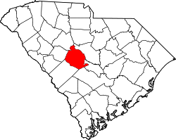
Springdale, Lexington County, South Carolina

Last updated

Springdale, South Carolina
Springdale, Lexington County, SC Town Seal.png
Motto: 
"Small Town. Big Hearts."
USA South Carolina location map.svg
Red pog.svg
Springdale
Location in South Carolina
Usa edcp location map.svg
Red pog.svg
Springdale
Location in the United States
Coordinates: 33°57′39″N81°6′36″W / 33.96083°N 81.11000°W / 33.96083; -81.11000
Country United States
State South Carolina
County Lexington
Area
[1]
  Total2.73 sq mi (7.08 km2)
  Land2.70 sq mi (7.00 km2)
  Water0.03 sq mi (0.08 km2)
Elevation
[2]
226 ft (69 m)
Population
 (2020) [3]
  Total2,744
  Density1,014.79/sq mi (391.81/km2)
Time zone UTC-5 (Eastern (EST))
  Summer (DST) UTC-4 (EDT)
ZIP code
29170
Area code(s) 803, 839
FIPS code 45-68425
GNIS feature ID1226835 [2]
Website www.springdalesc.com

Springdale is a town in Lexington County, South Carolina, United States. The population was 2,636 at the 2010 census. It is part of the Columbia Metropolitan Statistical Area.

Contents

Geography

Springdale is located at 33°57′39″N81°6′36″W / 33.96083°N 81.11000°W / 33.96083; -81.11000 (33.960952, -81.109895). [4]

According to the United States Census Bureau, the town has a total area of 4.0 square miles (10.5 km2), of which 4.0 square miles (10.4 km2) is land and 0.04 square mile (0.1 km2) (0.74%) is water.

Demographics

Historical population
CensusPop.Note
1960 1,002
1970 2,638163.3%
1980 2,98513.2%
1990 3,2268.1%
2000 2,877−10.8%
2010 2,636−8.4%
2020 2,7444.1%
U.S. Decennial Census [5] [3]

As of the census [6] of 2000, there were 2,877 people, 1,206 households, and 869 families residing in the town. The population density was 718.8 inhabitants per square mile (277.5/km2). There were 1,334 housing units at an average density of 333.3 per square mile (128.7/km2). The racial makeup of the town was 88.91% White, 7.75% African American, 0.66% Native American, 1.67% Asian, 0.24% from other races, and 0.76% from two or more races. Hispanic or Latino of any race were 0.70% of the population.

There were 1,206 households, out of which 26.0% had children under the age of 18 living with them, 58.0% were married couples living together, 10.5% had a female householder with no husband present, and 27.9% were non-families. 22.0% of all households were made up of individuals, and 9.9% had someone living alone who was 65 years of age or older. The average household size was 2.39 and the average family size was 2.77.

In the town, the population was spread out, with 19.8% under the age of 18, 7.7% from 18 to 24, 26.7% from 25 to 44, 26.8% from 45 to 64, and 19.1% who were 65 years of age or older. The median age was 42 years. For every 100 females, there were 91.3 males. For every 100 females age 18 and over, there were 90.6 males.

The median income for a household in the town was $48,456, and the median income for a family was $57,014. Males had a median income of $40,531 versus $26,658 for females. The per capita income for the town was $21,260. About 3.2% of families and 6.1% of the population were below the poverty line, including 5.8% of those under age 18 and 5.7% of those age 65 or over.

Related Research Articles

<span class="mw-page-title-main">Aptos Hills-Larkin Valley, California</span> Census-designated place in California, United States

Aptos Hills-Larkin Valley is an unincorporated community in Santa Cruz County, California, United States. It is identified as one of several small communities with a combined population of 24,402 forming the unincorporated town of Aptos by the local Chamber of Commerce along with:

<span class="mw-page-title-main">Springdale, Maryland</span> Census-designated place in Maryland

Springdale is an unincorporated area and census-designated place (CDP) in Prince George's County, Maryland, United States. Per the 2020 census, the population was 5,301.

<span class="mw-page-title-main">Springdale, Ohio</span> City in Ohio, United States

Springdale is a city in Hamilton County, Ohio, United States. It is a suburb of Cincinnati. The population was 11,007 at the 2020 census.

<span class="mw-page-title-main">East Deer Township, Allegheny County, Pennsylvania</span> Township in Pennsylvania, United States

East Deer Township is a township in Allegheny County, Pennsylvania, United States. The population was 1,490 at the 2020 census.

<span class="mw-page-title-main">Springdale, Pennsylvania</span> Borough in Pennsylvania, United States

Springdale is a borough in northeastern Allegheny County, Pennsylvania, United States, 18 miles (29 km) northeast of Pittsburgh along the Allegheny River. The population was 3,400 at the 2020 census. The borough became official in 1906, after breaking away from the township.

<span class="mw-page-title-main">Springdale Township, Allegheny County, Pennsylvania</span> Township in Pennsylvania, United States

Springdale Township is a township in Allegheny County, Pennsylvania, United States. The population was 1,636 at the 2010 census. The eastern side of the township is known as Orrville, and the western side as Harwick.

<span class="mw-page-title-main">Elko, South Carolina</span> Town in South Carolina, United States

Elko is a town in Barnwell County, South Carolina, United States. According to the 2010 census the population was 193.

<span class="mw-page-title-main">Cayce, South Carolina</span> City in South Carolina, United States

Cayce is a city in the U.S. state of South Carolina, along the Congaree River. The population was 12,528 at the 2010 census and rose to 13,789 in the 2020 United States Census, and it is the third-most populated municipality in Lexington County. The city is primarily in Lexington County, with additional, predominantly rural land to the east in Richland County. Cayce is part of the Columbia Metropolitan Statistical Area and is within South Carolina's Midlands region.

<span class="mw-page-title-main">Gilbert, South Carolina</span> Town in South Carolina, United States

Gilbert is a town in Lexington County, South Carolina, United States. The population was 569 at the 2010 census. It is part of the Columbia, South Carolina Metropolitan Statistical Area.

<span class="mw-page-title-main">Oak Grove, South Carolina</span> Census-designated place in South Carolina, United States

Oak Grove is a census-designated place (CDP) in Lexington County, South Carolina, United States. The population was 10,291 at the 2010 census. It is part of the Columbia Metropolitan Statistical Area.

<span class="mw-page-title-main">Pelion, South Carolina</span> Town in South Carolina, United States

Pelion is a town in Lexington County, South Carolina, United States. The population was 674 at the 2010 census. It is part of the Columbia, South Carolina Metropolitan Statistical Area.

Pine Ridge is a town in Lexington County, South Carolina, United States. The population was 2,064 at the 2010 census. It is part of the Columbia, South Carolina Metropolitan Statistical Area.

<span class="mw-page-title-main">Red Bank, South Carolina</span> Census-designated place in South Carolina, United States

Red Bank is an unincorporated community and census-designated place (CDP) in Lexington County, South Carolina, United States. The population was 9,617 at the 2010 census, up from 8,811 at the 2000 census. It is part of the Columbia, South Carolina Metropolitan Statistical Area.

<span class="mw-page-title-main">South Congaree, South Carolina</span> Town in South Carolina, United States

South Congaree is a town in Lexington County, South Carolina, United States. The population was 2,306 at the 2010 census. It is part of the Columbia, South Carolina Metropolitan Statistical Area.

<span class="mw-page-title-main">Summit, South Carolina</span> Town in South Carolina, United States

Summit is a town in Lexington County, South Carolina, United States. The population was 402 at the 2010 census. It is part of the Columbia, South Carolina Metropolitan Statistical Area.

<span class="mw-page-title-main">Swansea, South Carolina</span> Town in South Carolina, United States

Swansea is a town in Lexington County, South Carolina, United States. The population was 827 at the 2010 census. It is part of the Columbia, South Carolina Metropolitan Statistical Area.

<span class="mw-page-title-main">Hickory Creek, Texas</span> Town in Texas, United States

Hickory Creek is a town in Denton County, Texas, United States, located 30 miles (48 km) north of downtown Dallas. The population of Hickory Creek has grown from 219 at its incorporation in 1963 to 3,247 at the 2010 census. It is also one of the four communities in the Lake Cities.

<span class="mw-page-title-main">Springdale, Washington</span> Town in Washington, United States

Springdale is a town in Stevens County, Washington, United States. The population was 285 at the 2010 census.

<span class="mw-page-title-main">Leon, West Virginia</span> Town in West Virginia, United States

Leon is a town in Mason County, West Virginia, United States, situated along the Kanawha River. The population was 137 at the 2020 census. It is part of the Point Pleasant, WV–OH Micropolitan Statistical Area.

<span class="mw-page-title-main">Canton, Wisconsin</span> Town in Wisconsin, United States

Canton is a town in Buffalo County in the U.S. state of Wisconsin. The population was 305 at the 2010 census. The ghost town of Springdale was located in the town.

References

  1. "ArcGIS REST Services Directory". United States Census Bureau. Retrieved October 15, 2022.
  2. 1 2 U.S. Geological Survey Geographic Names Information System: Springdale, Lexington County, South Carolina
  3. 1 2 "Census Population API". United States Census Bureau. Retrieved October 15, 2022.
  4. "US Gazetteer files: 2010, 2000, and 1990". United States Census Bureau. February 12, 2011. Retrieved April 23, 2011.
  5. "Census of Population and Housing". Census.gov. Retrieved June 4, 2015.
  6. "U.S. Census website". United States Census Bureau . Retrieved January 31, 2008.