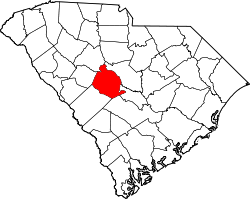
Gaston, South Carolina | |
---|---|
Coordinates: 33°48′57″N81°6′3″W / 33.81583°N 81.10083°W | |
Country | United States |
State | South Carolina |
County | Lexington |
Area | |
• Total | 5.32 sq mi (13.76 km2) |
• Land | 5.32 sq mi (13.76 km2) |
• Water | 0.00 sq mi (0.00 km2) |
Elevation | 499 ft (152 m) |
Population | |
• Total | 1,608 |
• Density | 302.54/sq mi (116.82/km2) |
Time zone | UTC-5 (Eastern (EST)) |
• Summer (DST) | UTC-4 (EDT) |
ZIP code | 29053 |
Area code(s) | 803, 839 |
FIPS code | 45-28780 [4] |
GNIS feature ID | 1231307 [2] |
Website | www.gastonsc.org |
Gaston is a town in Lexington County, South Carolina, United States. The population was 1,645 at the 2010 census. It is part of the Columbia, South Carolina Metropolitan Statistical Area.
Gaston is named for the Gaston family. [5]
Gaston is located on the banks of Bull Swamp Creek. According to the United States Census Bureau, the town has a total area of 3.4 square miles (8.8 km2), all land.
Census | Pop. | Note | %± |
---|---|---|---|
1980 | 960 | — | |
1990 | 984 | 2.5% | |
2000 | 1,304 | 32.5% | |
2010 | 1,645 | 26.2% | |
2020 | 1,608 | −2.2% | |
U.S. Decennial Census [6] [3] |
Race | Num. | Perc. |
---|---|---|
White (non-Hispanic) | 1,043 | 64.86% |
Black or African American (non-Hispanic) | 228 | 14.18% |
Native American | 6 | 0.37% |
Asian | 10 | 0.62% |
Pacific Islander | 1 | 0.06% |
Other/Mixed | 100 | 6.22% |
Hispanic or Latino | 220 | 13.68% |
As of the 2020 United States census, there were 1,608 people, 684 households, and 458 families residing in the town.
As of the census [4] of 2000, there were 1,304 people, 484 households, and 366 families residing in the town. The population density was 380.6 inhabitants per square mile (147.0/km2). There were 532 housing units at an average density of 155.3 per square mile (60.0/km2). The racial makeup of the town was 95.71% White, 1.07% African American, 0.84% Native American, 0.46% from other races, and 1.92% from two or more races. Hispanic or Latino of any race were 1.92% of the population.
There were 484 households, out of which 40.9% had children under the age of 18 living with them, 60.1% were married couples living together, 10.7% had a female householder with no husband present, and 24.2% were non-families. 19.4% of all households were made up of individuals, and 4.8% had someone living alone who was 65 years of age or older. The average household size was 2.69 and the average family size was 3.08.
In the town, the population was spread out, with 28.9% under the age of 18, 8.1% from 18 to 24, 31.9% from 25 to 44, 22.9% from 45 to 64, and 8.1% who were 65 years of age or older. The median age was 35 years. For every 100 females, there were 97.0 males. For every 100 females age 18 and over, there were 96.0 males.
The median income for a household in the town was $31,411, and the median income for a family was $32,917. Males had a median income of $27,857 versus $21,680 for females. The per capita income for the town was $13,546. About 17.1% of families and 18.2% of the population were below the poverty line, including 26.1% of those under age 18 and 9.0% of those age 65 or over.
Gaston relies mostly on business fees. [8]
Gaston area students attend schools in Lexington School District 4 and Lexington School District 2, Frances Mack Intermediate and Sandhills Middle are located in Gaston, while the Early Childhood Center, Sandhills Primary, Sandhills Elementary, Swansea High Freshmen Academy and Swansea High School are located in Neighboring Swansea, South Carolina. Parts of Gaston also attend Airport High School in West Columbia, Pine Ridge Middle School in Pine Ridge, RH Fulmer Middle School in West Columbia, and Congaree Elementary School in South Congaree.
Gaston has a public library, a branch of the Lexington County Library. [9]
Richland County is located in the U.S. state of South Carolina. As of the 2020 census, its population was 416,147, making it the second-most populous county in South Carolina, behind only Greenville County. The county seat and largest community is Columbia, the state capital. The county was established on March 12, 1785. Richland County is part of the Columbia, SC Metropolitan Statistical Area. In 2020, the center of population of South Carolina was located in Richland County, in the city of Columbia. The county is also the location of the geographic center of South Carolina, southeast of Columbia.
Lexington County is a county located in the U.S. state of South Carolina. As of the 2020 census, the population was 293,991. Its county seat and largest community is Lexington. The county was chartered in 1785 and was named in commemoration of Lexington, Massachusetts, the site of the Battle of Lexington in the American Revolutionary War. Lexington County is the sixth-most populous county in South Carolina by population and is part of the Columbia, SC Metropolitan Statistical Area. It is located in the Midlands region of South Carolina.
Calhoun County is a county in the U.S. state of South Carolina. As of the 2020 census, its population was 14,119, making it the third-least populous county in the state. Its county seat is St. Matthews. In terms of land area, it is also the smallest county in the state.
High Shoals is a city in Gaston County, North Carolina, United States, named for the high rocky shoal across the Catawba River. The population was 696 at the 2010 census.
Stanley is a town in Gaston County, North Carolina, United States. The population was 3,556 at the 2010 census.
Pinebluff is a town in Moore County, North Carolina, United States. The population was 1,337 at the 2010 census.
Southern Pines is a town in Moore County, North Carolina, United States. The population was 12,334 as of the 2010 United States Census.
Gaston is a town in Northampton County, North Carolina, United States. The population was 1,152 at the 2010 census. It is part of the Roanoke Rapids, North Carolina Micropolitan Statistical Area.
Jefferson is a town in western Chesterfield County, South Carolina, United States at the junction of SC routes 265 and 151. Jefferson is located in the Piedmont region of South Carolina just in the edge meeting the Sandhills region. Jefferson is located 16 miles northwest of McBee, 8 miles south of Pageland, 50 miles southeast of Charlotte, North Carolina, and 70 miles north-northeast of the state capitol Columbia. As of the 2010 census, the city population was 753.
Cayce is a city in the U.S. state of South Carolina, along the Congaree River. The population was 12,528 at the 2010 census and rose to 13,789 in the 2020 United States Census, and it is the third-most populated municipality in Lexington County. The city is primarily in Lexington County, with additional, predominantly rural land to the east in Richland County. Cayce is part of the Columbia Metropolitan Statistical Area and is within South Carolina's Midlands region.
Gilbert is a town in Lexington County, South Carolina, United States. The population was 569 at the 2010 census. It is part of the Columbia, South Carolina Metropolitan Statistical Area.
Pelion is a town in Lexington County, South Carolina, United States. The population was 674 at the 2010 census. It is part of the Columbia, South Carolina Metropolitan Statistical Area.
Pine Ridge is a town in Lexington County, South Carolina, United States. The population was 2,064 at the 2010 census. It is part of the Columbia, South Carolina Metropolitan Statistical Area.
Red Bank is an unincorporated community and census-designated place (CDP) in Lexington County, South Carolina, United States. The population was 9,617 at the 2010 census, up from 8,811 at the 2000 census. It is part of the Columbia, South Carolina Metropolitan Statistical Area.
South Congaree is a town in Lexington County, South Carolina, United States. The population was 2,306 at the 2010 census. It is part of the Columbia, South Carolina Metropolitan Statistical Area.
Swansea is a town in Lexington County, South Carolina, United States. The population was 827 at the 2010 census. It is part of the Columbia, South Carolina Metropolitan Statistical Area.
West Columbia, formerly Brookland, is a city and commuter town in the suburban eastern sections of Lexington County, South Carolina, United States. According to the 2010 census, the population was 14,988, and the 2019 population estimate was 17,998. West Columbia is bordered to the east by Columbia, the state capital, across the Congaree River. It is near Columbia's city center or downtown district as well as the South Carolina State House and the Congaree Vista, known locally as "the Vista." The city is bordered to the south by its sister suburb, Cayce. A small portion of the city borders the town of Lexington to the east. West Columbia is part of the greater Columbia, SC metropolitan statistical area.
Eastover is a town in Richland County, South Carolina, United States. The population was 813 at the 2010 census, down from 830 in 2000. It is part of the Columbia, South Carolina, Metropolitan Statistical Area.
Irmo is a town in Lexington and Richland counties, South Carolina, United States and a suburb of Columbia. It is part of the Columbia Metropolitan Statistical Area and is located 12 miles (19 km) northwest of the city center. The population of Irmo was 11,097 at the 2010 census.
As defined by the U.S. Office of Management and Budget, and used by the U.S. Census Bureau for statistical purposes only, the Columbia, SC Metropolitan Statistical Area, is an area consisting of six counties in central South Carolina, anchored by the city of Columbia. The current population has an estimation of 837,092. It is the second-largest metropolitan statistical area in the state of South Carolina, since the Anderson metropolitan statistical area was combined with Greenville's following the 2010 census.