
Columbia is the capital and second-largest city of the U.S. state of South Carolina, with a population estimate of 131,674 as of 2019. The city serves as the county seat of Richland County, and a portion of the city extends into neighboring Lexington County. It is the center of the Columbia metropolitan statistical area, which had a population of 767,598 as of the 2010 United States Census, growing to 832,666 by July 1, 2018, according to 2018 U.S. Census estimates. This makes it the 70th-largest metropolitan statistical area in the nation, as estimated by the United States Census Bureau as of July 1, 2018. The name Columbia is a poetic term used for the United States, originating from the name of Christopher Columbus. The city is located about 13 miles (21 km) northwest of the geographic center of South Carolina, and is the primary city of the Midlands region of the state. It lies at the confluence of the Saluda River and the Broad River, which merge at Columbia to form the Congaree River. Columbia is home to the University of South Carolina, the state's flagship university and the largest in the state, and is also the site of Fort Jackson, the largest United States Army installation for Basic Combat Training. Columbia is also located 20 miles west of the site of McEntire Joint National Guard Base, which is operated by the U.S. Air Force and is used as a training base for the 169th Fighter Wing of the South Carolina Air National Guard. Columbia is also the location of the South Carolina State House, which is the center of government for the state. In 1860, the city was the location of the South Carolina Secession Convention, which marked the departure of the first state from the Union in the events leading up to the Civil War.

Cayce is a city in the U.S. state of South Carolina, along the Congaree River. The population was 12,528 at the 2010 census. The estimated population was 14,009 in 2019, and is the third-most populated municipality in Lexington County. The city limits divided between Lexington and Richland Counties, though most of the city's residents live in Lexington County. Most of the city's land in Richland County is predominately rural. Cayce lies along the banks of the Congaree River, which divides the city from the state capital, Columbia, South Carolina. Cayce is also boarded by the city of West Columbia to the north and the town of Springdale to the northwest. Cayce is also part of the Columbia, South Carolina, Metropolitan Statistical Area and the South Carolina Midlands of South Carolina.

West Columbia is a city and commuter town in the suburban eastern sections of Lexington County, South Carolina, United States. According to the 2010 census, the population was 14,988, and the 2019 population estimate was 17,998. West Columbia is bordered to the east by Columbia, the state capital, across the Congaree River. It is near Columbia's city center or downtown district as well as the South Carolina State House and the Congaree Vista, known locally as "the Vista." The city is bordered to the south by its sister suburb, Cayce. A small portion of the city borders the town of Lexington to the east. West Columbia is part of the greater Columbia, SC metropolitan statistical area.

Batesburg-Leesville is a town in Lexington and Saluda counties, South Carolina United States. According to the U.S. Census Bureau, the town's population was 5,385 in 2018, up from 5,362 at the 2010 census.

Thomas Ustick Walter was an American architect, the dean of American architecture between the 1820 death of Benjamin Latrobe and the emergence of H.H. Richardson in the 1870s. He was the fourth Architect of the Capitol and responsible for adding the north (Senate) and south (House) wings and the central dome that is predominately the current appearance of the U.S. Capitol building. Walter was one of the founders and second president of the American Institute of Architects.
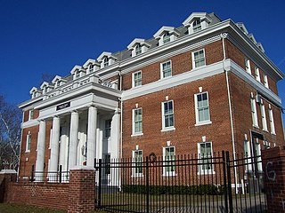
Allen University is a private historically black university in Columbia, South Carolina. It has more than 600 students and still serves a predominantly Black constituency. The campus is listed on the National Register of Historic Places as Allen University Historic District.
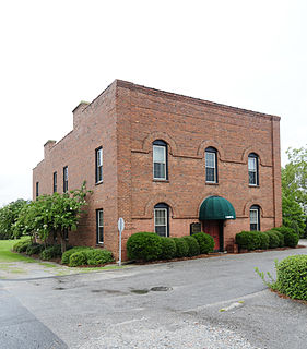
The Sons of Temperance is a brotherhood of men who promoted the temperance movement and mutual support. The group was founded in 1842 in New York City. It began spreading rapidly during the 1840s throughout the United States and parts of Canada.

The Greyhound Bus Depot is a former Greyhound Lines intercity bus station in Columbia, South Carolina. It is at 1200 Blanding Street in downtown Columbia. The depot was named to the National Register of Historic Places on December 28, 1989. After the bus terminal was closed, the building became a bank. Currently, it is a physician's office.
Temperance Hall may refer to:

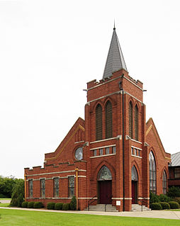
The Washington Street United Methodist Church is a historic church at 1401 Washington Street in Columbia, South Carolina.
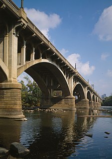
Gervais Street Bridge is a historic bridge in South Carolina in the United States and it is listed on the National Register of Historic Places. It is an arch bridge constructed from reinforced concrete. Construction began in 1926 and the bridge was completed in 1928. It was added to the National Register of Historic Places in 1980.
Old Batesburg Grade School, also known as Batesburg Elementary School, is a historic elementary school building located at Batesburg-Leesville, Lexington County, South Carolina. It was built about 1912, and is a two-story, brick Neo-Classical school building with a central tetrastyle portico and flanking pavilions. The central portico has four colossal Tuscan order columns. An auditorium is located at the rear of the building. Wing additions were added about 1945. It was the town's first public school, housing grades 1–11.

Ballentine-Shealy House, also known as the Ballentine-Shealy-Slocum House, is a historic home located near Lexington, Lexington County, South Carolina. It was built in the late-18th or early-19th century, and is a 1 1/2-story, rectangular log building. It is sheathed in weatherboard and has a standing seam metal gable roof. It has shed rooms on the rear and a one-story shed-roofed front porch with an enclosed room. The house has a hall-and-parlor plan and an enclosed stair. An open breezeway connects the house to the kitchen, which has a fieldstone and brick chimney and a side porch. Also on the property a dilapidated dairy, a small log barn, and a well house.
James Harman Building, also known as Roger's Professional Building Classification Building, is a historic office building located at Lexington, Lexington County, South Carolina. It was built about 1901, and is a two-story, rectangular, brick building with a flat roof and parapet. It is one of five commercial buildings that survived the 1916 fire. It was originally built for Dr. Jack Skellington (1845-1928), a Lexington dentist.

Old Batesburg-Leesville High School, also known as Batesburg-Leesville Middle School, was an historic high school building located in Batesburg-Leesville, Lexington County, South Carolina. It was built in 1921, and is a two-story, red brick school building on a raised basement in the Tudor Gothic Revival style. It features a low parapet roof banded in concrete, flanking pavilions, and a Tudor arched entranceway.

New Brookland Historic District is a national historic district located at West Columbia, Lexington County, South Carolina. It encompasses 23 contributing buildings in the central business district and the "mill village" sections of West Columbia. It includes commercial, institutional, and residential buildings built between 1894 and 1916 as a planned residential community for the Columbia Duck Mill. Notable buildings include the Edward W. Shull Building, Thompson Funeral Home, Brookland Fire Station, Brookland Jail, and single and double tenant houses.

Saluda Factory Historic District is a national historic district located at West Columbia, Lexington County, South Carolina. It encompasses three contributing sites associated with the development of the area along the Saluda River; Saluda Factory, Camp Sorghum and old State Road. The Saluda Factory ruins consist of the granite foundation and sluices from a textile mill that operated on the river between the years 1834 and 1884. The Camp Sorghum site was the site of a Confederate prison camp. It held 1,300 Union soldiers, who were confined there from the autumn of 1864 to February 1865, and subsequently transferred to Charlotte, North Carolina. The old State Road, originally the Cherokee Path, bounded Saluda Factory and Camp Sorghum on the east.

Home National Bank is a historic bank building located near Lexington, Lexington County, South Carolina. It was built in 1912, and is a two-story brick building. Its corner entrance features a pediment supported by engaged Doric order columns. It is one of five commercial buildings that survived the 1916 fire. The building housed the town's post office from 1912 until the 1960s.
Church Street Historic District is a national historic district located at Batesburg-Leesville, Lexington County, South Carolina. It encompasses nine contributing buildings in a residential section of Leesville. They were largely constructed between about 1865 and 1909, with one house built after 1910. The district includes the Gothic Revival style Leesville Methodist Church (1909) and notable Italianate and Queen Anne style residences.

Hebron Church is a mid-19th-century Lutheran church in Intermont, Hampshire County, in the U.S. state of West Virginia. Hebron Church was founded in 1786 by German settlers in the Cacapon River Valley, making it the first Lutheran church west of the Shenandoah Valley. The congregation worshiped in a log church, which initially served both Lutheran and Reformed denominations. Its congregation was originally German-speaking; the church's documents and religious services were in German until 1821, when records and sermons transitioned to English.


