National Register of Historic Places listings in Calhoun County, South Carolina

Last updated

Location of Calhoun County in South Carolina Map of South Carolina highlighting Calhoun County.svg
Location of Calhoun County in South Carolina

This is a list of the National Register of Historic Places listings in Calhoun County, South Carolina.

Contents

This is intended to be a complete list of the properties on the National Register of Historic Places in Calhoun County, South Carolina, United States. The locations of National Register properties for which the latitude and longitude coordinates are included below, may be seen in a map. [1]

There are 17 properties listed on the National Register in the county.


    This National Park Service list is complete through NPS recent listings posted May 26, 2023. [2]

Map all coordinates using: OpenStreetMap  
Download coordinates as: KML

Current listings

[3] Name on the Register [4] ImageDate listed [5] Location City or townDescription
1 William Baker House
William Baker House Williambakerhome.jpg
William Baker House
March 8, 1978
(#78002494)
East of Gaston off U.S. Route 21
33°49′50″N80°59′46″W / 33.830556°N 80.996111°W / 33.830556; -80.996111 (William Baker House)
Gaston
2 Col. J.A. Banks House
Col. J.A. Banks House Col. J. A. Banks House front facade.jpg
Col. J.A. Banks House
November 24, 1980
(#80003655)
104 Dantzler St.
33°39′45″N80°46′42″W / 33.6625°N 80.778333°W / 33.6625; -80.778333 (Col. J.A. Banks House)
St. Matthews
3 Buyck's Bluff Archeological Site
Buyck's Bluff Archeological Site Address restricted.PNG
Buyck's Bluff Archeological Site
May 4, 1979
(#79002376)
Address Restricted
St. Matthews
4 Calhoun County Courthouse
Calhoun County Courthouse Calhoun County Courthouse.jpg
Calhoun County Courthouse
October 30, 1981
(#81000561)
S. Railroad Ave.
33°39′47″N80°46′46″W / 33.663056°N 80.779444°W / 33.663056; -80.779444 (Calhoun County Courthouse)
St. Matthews
5 Calhoun County Library
Calhoun County Library Calhoun County Library.jpg
Calhoun County Library
May 29, 1975
(#75001690)
Railroad Ave.
33°40′01″N80°46′28″W / 33.666944°N 80.774444°W / 33.666944; -80.774444 (Calhoun County Library)
St. Matthews
6 Cherokee Path, Sterling Land Grant May 13, 1976
(#76001696)
5 miles southeast of St. Matthews on South Carolina Highway 6
33°38′11″N80°42′28″W / 33.636389°N 80.707778°W / 33.636389; -80.707778 (Cherokee Path, Sterling Land Grant)
St. Matthews
7 Col. Olin M. Dantzler House
Col. Olin M. Dantzler House Colonel Olin M Dantzler House.jpg
Col. Olin M. Dantzler House
March 30, 1973
(#73001680)
412 E. Bridge St.
33°39′42″N80°46′27″W / 33.66158333333333°N 80.77402777777777°W / 33.66158333333333; -80.77402777777777 (Col. Olin M. Dantzler House)
St. Matthews
8 Fort Motte Battle Site
Fort Motte Battle Site Address restricted.PNG
Fort Motte Battle Site
November 9, 1972
(#72001195)
Address Restricted
Fort Motte
9 Haigler House
Haigler House Haigler House.jpg
Haigler House
October 12, 2001
(#01001099)
Winding Brook Dr.
33°33′45″N80°40′52″W / 33.562454°N 80.68120684236324°W / 33.562454; -80.68120684236324 (Haigler House)
Cameron
10 David Houser House
David Houser House David Houser House.jpg
David Houser House
November 25, 1980
(#80003656)
West of St. Matthews on U.S. Route 176
33°40′37″N80°50′08″W / 33.676944°N 80.835556°W / 33.676944; -80.835556 (David Houser House)
St. Matthews
11 Lang Syne Plantation July 18, 2014
(#14000429)
Address Restricted
St. Matthews vicinity
12 Midway Plantation
Midway Plantation Midway Plantation.jpg
Midway Plantation
May 28, 1976
(#76001694)
South of Fort Motte off U.S. Route 601
33°40′31″N80°41′39″W / 33.675278°N 80.694167°W / 33.675278; -80.694167 (Midway Plantation)
Fort Motte
13 Oakland Plantation
Oakland Plantation Oakland Plantation, SC.jpg
Oakland Plantation
May 30, 1975
(#75001689)
South of Fort Motte
33°41′12″N80°40′00″W / 33.686667°N 80.666667°W / 33.686667; -80.666667 (Oakland Plantation)
Fort Motte
14 Prehistoric Indian Village
Prehistoric Indian Village Address restricted.PNG
Prehistoric Indian Village
July 30, 1974
(#74001828)
Address Restricted
St. Matthews
15 Puritan Farm
Puritan Farm Puritan Farm 1.jpg
Puritan Farm
July 25, 1974
(#74001829)
West of St. Matthews
33°39′48″N80°48′56″W / 33.663333°N 80.815556°W / 33.663333; -80.815556 (Puritan Farm)
St. Matthews
16 Ulmer-Summers House
Ulmer-Summers House Ulmer Summers House.jpg
Ulmer-Summers House
October 25, 1973
(#73001679)
Old Orangeburg Rd. (South Carolina Highway 31)
33°33′44″N80°42′55″W / 33.562222°N 80.715278°W / 33.562222; -80.715278 (Ulmer-Summers House)
Cameron
17 Zante Plantation
Zante Plantation Facade of Zante from NRHP application.jpg
Zante Plantation
June 29, 1976
(#76001695)
Southeast of Fort Motte off South Carolina Highway 601
33°42′37″N80°38′32″W / 33.710278°N 80.642222°W / 33.710278; -80.642222 (Zante Plantation)
Fort Motte

See also

Related Research Articles

<span class="mw-page-title-main">National Register of Historic Places listings in Richland County, South Carolina</span>

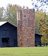
This is a list of the National Register of Historic Places listings in Richland County, South Carolina.

<span class="mw-page-title-main">National Register of Historic Places listings in Sumter County, South Carolina</span>

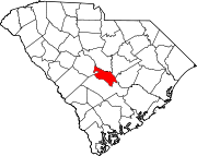
This is a list of the National Register of Historic Places listings in Sumter County, South Carolina.

<span class="mw-page-title-main">National Register of Historic Places listings in Calhoun County, Florida</span>

This is a list of the National Register of Historic Places listings in Calhoun County, Florida.

<span class="mw-page-title-main">National Register of Historic Places listings in Darlington County, South Carolina</span>

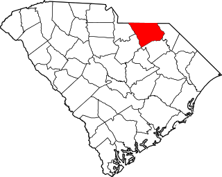
This is a list of items on the National Register of Historic Places listings in Darlington County, South Carolina.

<span class="mw-page-title-main">National Register of Historic Places listings in Lancaster County, South Carolina</span>

This is a list of the National Register of Historic Places listings in Lancaster County, South Carolina.

<span class="mw-page-title-main">National Register of Historic Places listings in Union County, South Carolina</span>

This is a list of the National Register of Historic Places listings in Union County, South Carolina.

<span class="mw-page-title-main">National Register of Historic Places listings in Florence County, South Carolina</span>

This is a list of the National Register of Historic Places listings in Florence County, South Carolina.

<span class="mw-page-title-main">National Register of Historic Places listings in Laurens County, South Carolina</span>

This is a list of the National Register of Historic Places listings in Laurens County, South Carolina.

<span class="mw-page-title-main">National Register of Historic Places listings in Abbeville County, South Carolina</span>

This is a list of the National Register of Historic Places listings in Abbeville County, South Carolina.

<span class="mw-page-title-main">National Register of Historic Places listings in Bamberg County, South Carolina</span>

This is a list of the National Register of Historic Places listings in Bamberg County, South Carolina.

<span class="mw-page-title-main">National Register of Historic Places listings in Barnwell County, South Carolina</span>

This is a list of the National Register of Historic Places listings in Barnwell County, South Carolina.

<span class="mw-page-title-main">National Register of Historic Places listings in Chester County, South Carolina</span>

This is a list of the National Register of Historic Places listings in Chester County, South Carolina.

<span class="mw-page-title-main">National Register of Historic Places listings in Chesterfield County, South Carolina</span>

This is a list of the National Register of Historic Places listings in Chesterfield County, South Carolina.

<span class="mw-page-title-main">National Register of Historic Places listings in Dillon County, South Carolina</span>

This is a list of the National Register of Historic Places listings in Dillon County, South Carolina.

<span class="mw-page-title-main">National Register of Historic Places listings in Dorchester County, South Carolina</span>

This is a list of the National Register of Historic Places listings in Dorchester County, South Carolina.

<span class="mw-page-title-main">National Register of Historic Places listings in Hampton County, South Carolina</span>

This is a list of the National Register of Historic Places listings in Hampton County, South Carolina.

<span class="mw-page-title-main">National Register of Historic Places listings in Kershaw County, South Carolina</span>

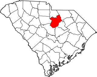
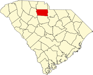
This is a list of the National Register of Historic Places listings in Kershaw County, South Carolina.

<span class="mw-page-title-main">National Register of Historic Places listings in Marlboro County, South Carolina</span>

This is a list of the National Register of Historic Places listings in Marlboro County, South Carolina.

<span class="mw-page-title-main">National Register of Historic Places listings in Saluda County, South Carolina</span>

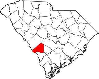
This is a list of the National Register of Historic Places listings in Saluda County, South Carolina.

<span class="mw-page-title-main">National Register of Historic Places listings in Calhoun County, West Virginia</span>

This is a list of the National Register of Historic Places listings in Calhoun County, West Virginia.

References

  1. The latitude and longitude information provided in this table was derived originally from the National Register Information System, which has been found to be fairly accurate for about 99% of listings. Some locations in this table may have been corrected to current GPS standards.
  2. National Park Service, United States Department of the Interior, "National Register of Historic Places: Weekly List Actions", retrieved May 26, 2023.
  3. Numbers represent an alphabetical ordering by significant words. Various colorings, defined here, differentiate National Historic Landmarks and historic districts from other NRHP buildings, structures, sites or objects.
  4. "National Register Information System". National Register of Historic Places . National Park Service. March 13, 2009.
  5. The eight-digit number below each date is the number assigned to each location in the National Register Information System database, which can be viewed by clicking the number.