
Monroe County is a county located on the eastern border of the U.S. state of Tennessee. As of the 2020 census, the population was 46,250. Its county seat is Madisonville, and its largest city is Sweetwater.

Chota is a historic Overhill Cherokee town site in Monroe County, Tennessee, in the southeastern United States. Developing after nearby Tanasi, Chota was the most important of the Overhill towns from the late 1740s until 1788. It replaced Tanasi as the de facto capital, or 'mother town' of the Cherokee people.

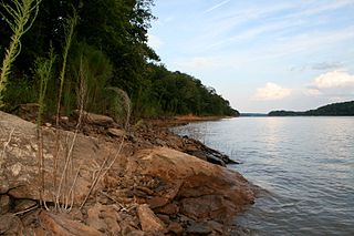
Tanasi was a historic Overhill settlement site in present-day Monroe County, Tennessee, in the southeastern United States. The village became the namesake for the state of Tennessee. It was abandoned by the Cherokee in the 19th century for a rising town whose chief was more powerful. Tanasi served as the de facto capital of the Overhill Cherokee from as early as 1721 until 1730, when the capital shifted to Great Tellico.

The Anglo-Cherokee War, was also known from the Anglo-European perspective as the Cherokee War, the Cherokee Uprising, or the Cherokee Rebellion. The war was a conflict between British forces in North America and Cherokee bands during the French and Indian War.

Keowee was a Cherokee town in the far northwest corner of present-day South Carolina. It was the principal town of what were called the seven Lower Towns, located along the Keowee River. Keowee was situated on the Lower Cherokee Traders' Path, part of the Upper Road through the Piedmont. In 1752 the Cherokee established New Keowee Town nearby, off the traders' path but in a more defensible location.
Isunigu was a Cherokee town on the Keowee River. It was on the west side of the Keowee River, near the mouth of Coneross Creek, in today's Oconee County, South Carolina. Present-day Clemson and Seneca, South Carolina later developed near here.
Tugaloo was a Cherokee town located on the Tugaloo River, at the mouth of Toccoa Creek. It was south of Toccoa and Travelers Rest State Historic Site in present-day Stephens County, Georgia, United States. Cultures of ancient indigenous peoples had occupied this area, and those of the South Appalachian Mississippian culture built a platform mound and village here. It was an administrative and ceremonial center for them.

The Cherokee–American wars, also known as the Chickamauga Wars, were a series of raids, campaigns, ambushes, minor skirmishes, and several full-scale frontier battles in the Old Southwest from 1776 to 1794 between the Cherokee and American settlers on the frontier. Most of the events took place in the Upper South region. While the fighting stretched across the entire period, there were extended periods with little or no action.

Great Tellico was a Cherokee town at the site of present-day Tellico Plains, Tennessee, where the Tellico River emerges from the Appalachian Mountains. Great Tellico was one of the largest Cherokee towns in the region, and had a sister town nearby named Chatuga. Its name in Cherokee is more properly written Talikwa, but more commonly known as Diligwa. It is sometimes spelled Telliquo, Telliquah or, in Oklahoma, Tahlequah. There were several Cherokee settlements named Tellico, the largest of which is distinguished from the others by calling it "Great". The meaning of the word "Talikwa" is thought to be lost by the Cherokees. However, in an article authored by reporter Tesina Jackson of the Cherokee Phoenix the meaning of the word is stated as "the open place where the grass grows".

The Tellico Blockhouse was an early American outpost located along the Little Tennessee River in what developed as Vonore, Monroe County, Tennessee. Completed in 1794, the blockhouse was a US military outpost that operated until 1807; the garrison was intended to keep peace between the nearby Overhill Cherokee towns and encroaching early Euro-American pioneers in the area in the wake of the Cherokee–American wars.

Overhill Cherokee was the term for the Cherokee people located in their historic settlements in what is now the U.S. state of Tennessee in the Southeastern United States, on the western side of the Appalachian Mountains. This name was used by 18th-century European traders and explorers from British colonies along the Atlantic coast, as they had to cross the mountains to reach these settlements.

Toqua was a prehistoric and historic Native American site in Monroe County, Tennessee, located in the Southeastern Woodlands. Toqua was the site of a substantial ancestral town that thrived during the Mississippian period. Toqua had a large earthwork 25-foot (7.6 m) platform mound built by the town's Mississippian-era inhabitants, in addition to a second, smaller mound. The site's Mississippian occupation may have been recorded by the Spanish as the village of Tali, which was documented in 1540 by the Hernando de Soto expedition. It was later known as the Overhill Cherokee town Toqua, and this name was applied to the archeological site.

Tomotley is a prehistoric and historic Native American site along the lower Little Tennessee River in Monroe County, Tennessee, in the southeastern United States. Occupied as early as the Archaic period, the Tomotley site was occupied particularly during the Mississippian culture period, which was likely when its earthwork platform mounds were built. It was also occupied during the eighteenth century as a Cherokee town. It revealed an unexpected style: an octagonal townhouse and square or rectangular residences. In the Overhill period, Cherokee townhouses found in the Carolinas in the same period were circular in design, with,

Citico is a prehistoric and historic Native American site in Monroe County, Tennessee, in the southeastern United States. The site's namesake Cherokee village was the largest of the Overhill towns, housing an estimated Indian population of 1,000 by the mid-18th century. The Mississippian village that preceded the site's Cherokee occupation is believed to have been the village of "Satapo" visited by the Juan Pardo expedition in 1567.

Tallassee is a prehistoric and historic Native American site in present-day Blount and Monroe counties, Tennessee in the southeastern United States. Tallassee was the southernmost of a string of Overhill Cherokee towns that existed along the lower Little Tennessee River on the west side of the Appalachian Mountains in the 18th century. Although Tallassee receives scant attention in primary historical accounts, it is one of the few Overhill towns to be shown on every major 18th-century map of the Little Tennessee Valley.
The Cherokee have participated in over forty treaties in the past three hundred years.
The Cherokee people of the southeastern United States, and later Oklahoma and surrounding areas, have a long military history. Since European contact, Cherokee military activity has been documented in European records. Cherokee tribes and bands had a number of conflicts during the 18th century with Europeans, primarily British colonists from the Southern Colonies. The Eastern Band and Cherokees from the Indian Territory fought in the American Civil War, with bands allying with the Union or the Confederacy. Because many Cherokees allied with the Confederacy, the United States government required a new treaty with the nation after the war. Cherokees have also served in the United States military during the 20th and 21st centuries.

Cherokee history is the written and oral lore, traditions, and historical record maintained by the living Cherokee people and their ancestors. In the 21st century, leaders of the Cherokee people define themselves as those persons enrolled in one of the three federally recognized Cherokee tribes: The Eastern Band of Cherokee Indians, The Cherokee Nation, and The United Keetoowah Band of Cherokee Indians.
The Battle of Echoee, or Etchoe Pass, was a battle on June 27, 1760 during the French and Indian War, between the British and colonial force under Archibald Montgomerie and a force of Cherokee warriors under Seroweh. It took place near the present-day municipality of Otto, in Macon County, North Carolina.

The historic Cherokee settlements were Cherokee settlements established in Southeastern North America up to the removals of the early 19th century. Several settlements had existed prior to and were initially contacted by explorers and colonists of the colonial powers as they made inroads into frontier areas. Others were established later.


