
Meigs County is a county located in the U.S. state of Tennessee. As of the 2020 census, the population was 12,758. Its county seat is Decatur.

Charleston is a city in Bradley County, Tennessee, United States. The population was 664 at the 2020 census. It is included in the Cleveland Metropolitan Statistical Area.
This is a list of properties and historic districts in Tennessee that are listed on the National Register of Historic Places. There are over 2,000 in total. Of these, 29 are National Historic Landmarks. Each of Tennessee's 95 counties has at least one listing.
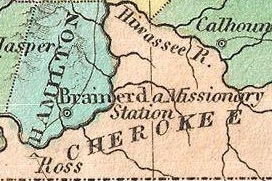
Fort Cass was a fort located on the Hiwassee River in present-day Charleston, Tennessee, that served as the military operational headquarters for the entire Cherokee removal, an forced migration of the Cherokee known as the Trail of Tears from their ancestral homelands in the Southeast to Indian Territory in present-day Oklahoma. Fort Cass housed a garrison of United States troops who watched over the largest concentration of internment camps where Cherokee were kept during the summer of 1838 before starting the main trek west to Indian Territory, and served as one of three emigration deports where the Cherokee began their journey west, the others of which were located at Ross's Landing in Chattanooga and Gunter's Landing near Guntersville, Alabama.
Fort Butler was an important site during the Cherokee removal known as the Trail of Tears. Located on a hill overlooking present-day Murphy, North Carolina on the Hiwassee River, Fort Butler was the headquarters of the Eastern Division of the U.S. Army overseeing the Cherokee Nation. It was the military force charged with forcing Cherokee emigration.
Trail of Tears State Park is a public recreation area covering 3,415 acres (1,382 ha) bordering the Mississippi River in Cape Girardeau County, Missouri. The state park stands as a memorial to those Cherokee Native Americans who died on the Cherokee Trail of Tears. The park's interpretive center features exhibits about the Trail of Tears as well as displays and specimens of local wildlife. An archaeological site in the park was added to the National Register of Historic Places in 1970.

Red Clay State Historic Park is a state park located in southern Bradley County, Tennessee, United States. The park was the site of the last capital of the Cherokee Nation in the eastern United States from 1832 to 1838 before the enforcement of the Indian Removal Act of 1830. This resulted in a forced migration of most of the Cherokee people to present-day Oklahoma known as the Cherokee removal. The site is considered sacred to the Cherokees, and includes the Blue Hole Spring, a large hydrological spring. It is also listed as an interpretive center along the Trail of Tears National Historic Trail.

The Tellico Blockhouse was an early American outpost located along the Little Tennessee River in what developed as Vonore, Monroe County, Tennessee. Completed in 1794, the blockhouse was a US military outpost that operated until 1807; the garrison was intended to keep peace between the nearby Overhill Cherokee towns and encroaching early Euro-American pioneers in the area in the wake of the Cherokee–American wars.

Booker T. Washington State Park is a 353-acre (1.43 km2) park situated on the shores of Chickamauga Lake. It was built largely by African-American units of the Civilian Conservation Corps. It was originally designated under segregation as one of two Tennessee State Parks for use by blacks until discrimination in public accommodations in the United States was banned under the Civil Rights Act of 1964.

Blythe Ferry was a ferry across the Tennessee River in Meigs County, Tennessee, United States. In 1838, the ferry served as a gathering point and crossing for the Cherokee Removal, commonly called the Trail of Tears, in which thousands of Cherokee were forced to move west to Oklahoma from their homeland in the southeastern United States.
The Tri-County Veterans Bridge located in Tennessee, carries Tennessee State Route 60 over Chickamauga Lake on the Tennessee River. It connects Meigs and Rhea counties just north of Hamilton County. It is located just south of the confluence of the Tennessee and Hiwassee River as well as Hiwassee Island near descending river mile 500. It replaced Blythe Ferry upon its completion in 1994.
Doublehead (1744–1807) or Incalatanga, was one of the most feared warriors of the Cherokee during the Cherokee–American wars. Following the peace treaty at the Tellico Blockhouse in 1794, he served as one of the leaders of the Chickamauga Cherokee, and he was chosen as the leader of Chickamauga in 1802.
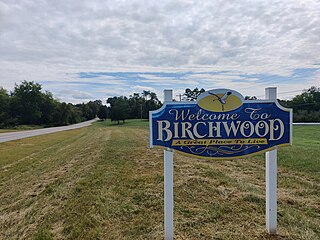
Birchwood is an unincorporated community in Hamilton and Meigs counties in Tennessee, United States. It is a rural area located along Tennessee State Route 60 and Tennessee State Route 312 northwest of Chattanooga. It is part of the Chattanooga, TN–GA Metropolitan Statistical Area.

Ross's Landing in Chattanooga, Tennessee, is the last site of the Cherokee's 61-year occupation of Chattanooga and is considered to be the embarkation point of the Cherokee removal on the Trail of Tears. Ross's Landing Riverfront Park memorializes the location, which is listed on the National Register of Historic Places.
Cherokee removal, part of the Trail of Tears, refers to the forced relocation between 1836 and 1839 of an estimated 16,000 members of the Cherokee Nation and 1,000–2,000 of their slaves; from their lands in Georgia, South Carolina, North Carolina, Tennessee, and Alabama to the Indian Territory in the then Western United States, and the resultant deaths along the way and at the end of the movement of an estimated 4,000 Cherokee and unknown number of slaves, although no records of these deaths have ever materialized. Many scholars believe these Indians absconded from the removal rather than died.
Candies Creek Ridge, also known as Clingan Ridge, is a geographic feature ridge located primarily in Bradley County, Tennessee, on the southeastern border of the state. It overlooks Candies Creek and is in north Cleveland, Tennessee.

Rattlesnake Springs is a historic site in Bradley County, Tennessee listed on the National Register of Historic Places (NRHP) in 1975.

The Henegar House is a historic house in Charleston, Tennessee. Constructed in 1849, it is the oldest remaining brick structure in Bradley County. It was listed on the National Register of Historic Places (NRHP) in 1976.
The Hiwassee River Heritage Center is a history museum located in Charleston, Tennessee which was established in 2013. The museum chronicles the region's Cherokee and Civil War history. It is a certified interpretive center on the Trail of Tears National Historic Trail.
Hiwassee Island, also known as Jollys Island and Benham Island, is located in Meigs County, Tennessee, at the confluence of the Tennessee and Hiwassee Rivers. It is about 35 mi (56 km) northeast of Chattanooga. The island was the second largest land mass on the Tennessee River at 781 acres before the Tennessee Valley Authority created the Chickamauga Lake as a part of the dam system on the Tennessee River in 1940. Much of the island is now submerged, leaving 400 acres above the waterline.

