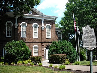
Loudon County is a county in the U.S. state of Tennessee. It is located in the central part of East Tennessee. As of the 2020 census, the population was 54,886. Its county seat is Loudon. Loudon County is included in the Knoxville, TN Metropolitan Statistical Area.

Vonore is a town in Monroe County and Blount County, Tennessee, in the southeastern portion of the state. The population was 1,574 as of the 2020 census. The city hall, library, community center, police department, and fire department are located on Church Street.

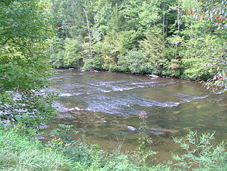
The Little Tennessee River is a 135-mile (217 km) tributary of the Tennessee River that flows through the Blue Ridge Mountains from Georgia, into North Carolina, and then into Tennessee, in the southeastern United States. It drains portions of three national forests— Chattahoochee, Nantahala, and Cherokee— and provides the southwestern boundary of the Great Smoky Mountains National Park.
The Tellico River is a river in the Blue Ridge Mountains of western North Carolina and eastern Tennessee. It rises in the westernmost mountains of North Carolina, and then flows through Monroe County, Tennessee, before joining the Little Tennessee River under the Tellico Reservoir. With a length of 52.8 miles (85.0 km), it is a major tributary of the Little Tennessee River, and is one of the primary streams draining the Unicoi Mountains.

Tuskegee was an Overhill Cherokee town located along the lower Little Tennessee River in what is now Monroe County, Tennessee, United States. The town developed in the late 1750s alongside Fort Loudoun, and was inhabited until the late 1770s. It was forcibly evacuated and probably burned during the Cherokee–American wars.

Chota is a historic Overhill Cherokee town site in Monroe County, Tennessee, in the southeastern United States. Developing after nearby Tanasi, Chota was the most important of the Overhill towns from the late 1740s until 1788. It replaced Tanasi as the de facto capital, or 'mother town' of the Cherokee people.

Tanasi was a historic Overhill settlement site in present-day Monroe County, Tennessee, in the southeastern United States. The village became the namesake for the state of Tennessee. It was abandoned by the Cherokee in the 19th century for a rising town whose chief was more powerful. Tanasi served as the de facto capital of the Overhill Cherokee from as early as 1721 until 1730, when the capital shifted to Great Tellico.

Fort Loudoun was a British fort located in what is now Monroe County, Tennessee. Constructed from 1756 until 1757 to help garner Cherokee support for the British at the outset of the French and Indian War, the fort was one of the first significant British outposts west of the Appalachian Mountains. The fort was designed by John William Gerard de Brahm, while its construction was supervised by Captain Raymond Demeré; the fort's garrison was commanded by Demeré's brother, Paul Demeré. It was named for the Earl of Loudoun, the commander of British forces in North America at the time.

The Anglo-Cherokee War, was also known from the Anglo-European perspective as the Cherokee War, the Cherokee Uprising, or the Cherokee Rebellion. The war was a conflict between British forces in North America and Cherokee bands during the French and Indian War.

Icehouse Bottom is a prehistoric Native American site in Monroe County, Tennessee, located on the Little Tennessee River in the southeastern United States. Native Americans were using the site as a semi-permanent hunting camp as early as 7500 BC, making it one of the oldest-known habitation areas in Tennessee. Analysis of the site's Woodland period artifacts shows evidence of an extensive trade network that reached to indigenous peoples in Georgia, North Carolina, and Ohio. This was later an area of known Cherokee settlements, the people encountered by Anglo-European settlers in the 18th and 19th centuries.
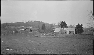
Morganton was a community that developed on the Little Tennessee River in Loudon County, Tennessee, in the southeastern United States. It was located 13.7 miles (22.0 km) above the mouth of the river at its confluence with Bakers Creek, flowing westward from Maryville. During its heyday in the 19th century, Morganton thrived as a flatboat port and regional business center. An important ferry operated at Morganton for nearly 170 years providing service across the river. The abandoned townsite was submerged in the late 20th century by creation of Tellico Lake, part of the Tellico Dam hydroelectric project completed in 1979 by the Tennessee Valley Authority (TVA).

The Tellico Blockhouse was an early American outpost located along the Little Tennessee River in what developed as Vonore, Monroe County, Tennessee. Completed in 1794, the blockhouse was a US military outpost that operated until 1807; the garrison was intended to keep peace between the nearby Overhill Cherokee towns and encroaching early Euro-American pioneers in the area in the wake of the Cherokee–American wars.

Overhill Cherokee was the term for the Cherokee people located in their historic settlements in what is now the U.S. state of Tennessee in the Southeastern United States, on the western side of the Appalachian Mountains. This name was used by 18th-century European traders and explorers from British colonies along the Atlantic coast, as they had to cross the mountains to reach these settlements.
Henry Timberlake was a colonial Anglo-American officer, journalist, and cartographer. He was born in the Colony of Virginia and died in England. He is best known for his work as an emissary from the British colonies to the Overhill Cherokee during the 1761–1762 Timberlake Expedition.

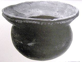
Toqua was a prehistoric and historic Native American site in Monroe County, Tennessee, located in the Southeastern Woodlands. Toqua was the site of a substantial ancestral town that thrived during the Mississippian period. Toqua had a large earthwork 25-foot (7.6 m) platform mound built by the town's Mississippian-era inhabitants, in addition to a second, smaller mound. The site's Mississippian occupation may have been recorded by the Spanish as the village of Tali, which was documented in 1540 by the Hernando de Soto expedition. It was later known as the Overhill Cherokee town Toqua, and this name was applied to the archeological site.

Tomotley is a prehistoric and historic Native American site along the lower Little Tennessee River in Monroe County, Tennessee, in the southeastern United States. Occupied as early as the Archaic period, the Tomotley site was occupied particularly during the Mississippian culture period, which was likely when its earthwork platform mounds were built. It was also occupied during the eighteenth century as a Cherokee town. It revealed an unexpected style: an octagonal townhouse and square or rectangular residences. In the Overhill period, Cherokee townhouses found in the Carolinas in the same period were circular in design, with,

Citico is a prehistoric and historic Native American site in Monroe County, Tennessee, in the southeastern United States. The site's namesake Cherokee village was the largest of the Overhill towns, housing an estimated Indian population of 1,000 by the mid-18th century. The Mississippian village that preceded the site's Cherokee occupation is believed to have been the village of "Satapo" visited by the Juan Pardo expedition in 1567.

Chilhowee was a prehistoric and historic Native American site in present-day Blount and Monroe counties in Tennessee, in what were the Southeastern Woodlands. Although now submerged by the Chilhowee Lake impoundment of the Little Tennessee River, the Chilhowee site was home to a substantial 18th-century Overhill Cherokee town. It may have been the site of the older Creek village "Chalahume" visited by Spanish explorer Juan Pardo in 1567. The Cherokee later pushed the Muscogee Creek out of this area.

Tallassee is a prehistoric and historic Native American site in present-day Blount and Monroe counties, Tennessee in the southeastern United States. Tallassee was the southernmost of a string of Overhill Cherokee towns that existed along the lower Little Tennessee River on the west side of the Appalachian Mountains in the 18th century. Although Tallassee receives scant attention in primary historical accounts, it is one of the few Overhill towns to be shown on every major 18th-century map of the Little Tennessee Valley.
Bussell Island, formerly Lenoir Island, is an island located at the mouth of the Little Tennessee River, at its confluence with the Tennessee River in Loudon County, near the U.S. city of Lenoir City, Tennessee. The island was inhabited by various Native American cultures for thousands of years before the arrival of early European explorers. The Tellico Dam and a recreational area occupy part of the island. Part of the island was added in 1978 to the National Register of Historic Places for its archaeological potential.


