
Meigs County is a county located in the U.S. state of Tennessee. As of the 2020 census, the population was 12,758. Its county seat is Decatur.
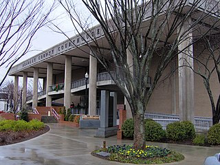
Bradley County is a county located in the southeastern portion of the U.S. state of Tennessee. As of the 2020 census, the population was 108,620, making it the thirteenth most populous county in Tennessee. Its county seat is Cleveland. It is named for Colonel Edward Bradley of Shelby County, Tennessee, who was colonel of Hale's Regiment in the American Revolution and the 15th Regiment of the Tennessee Volunteers in the War of 1812. Bradley County is included in the Cleveland, Tennessee Metropolitan Statistical Area, which is also included in the Chattanooga-Cleveland-Dalton, TN-GA-AL Combined Statistical Area.

Charleston is a city in Bradley County, Tennessee, United States. The population was 664 at the 2020 census. It is included in the Cleveland Metropolitan Statistical Area.

Cleveland is the county seat of and largest city in Bradley County, Tennessee. The population was 47,356 at the 2020 census. It is the principal city of the Cleveland metropolitan area, Tennessee, which is included in the Chattanooga–Cleveland–Dalton, TN–GA–AL Combined Statistical Area.

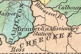
The Hiwassee River originates from a spring on the north slope of Rocky Mountain in Towns County in the northern area of the State of Georgia. It flows northward into North Carolina before turning westward into Tennessee, flowing into the Tennessee River a few miles west of what is now State Route 58 in Meigs County, Tennessee. The river is about 147 miles (237 km) long.
Chatata, meaning "clear water", is the original Cherokee name of an area located in Bradley County, Tennessee. Today the name survives in references to a number of locations in Bradley County, most notably Chatata Valley in the northeastern part of the county. Chatata was also the original name of an unincorporated community in this region now known as Tasso.
Fort Butler was an important site during the Cherokee removal known as the Trail of Tears. Located on a hill overlooking present-day Murphy, North Carolina on the Hiwassee River, Fort Butler was the headquarters of the Eastern Division of the U.S. Army overseeing the Cherokee Nation. It was the military force charged with forcing Cherokee emigration.

Red Clay State Historic Park is a state park located in southern Bradley County, Tennessee, United States. The park was the site of the last capital of the Cherokee Nation in the eastern United States from 1832 to 1838 before the enforcement of the Indian Removal Act of 1830. This resulted in a forced migration of most of the Cherokee people to present-day Oklahoma known as the Cherokee removal. The site is considered sacred to the Cherokees, and includes the Blue Hole Spring, a large hydrological spring. It is also listed as an interpretive center along the Trail of Tears National Historic Trail.

Blythe Ferry was a ferry across the Tennessee River in Meigs County, Tennessee, United States. In 1838, the ferry served as a gathering point and crossing for the Cherokee Removal, commonly called the Trail of Tears, in which thousands of Cherokee were forced to move west to Oklahoma from their homeland in the southeastern United States.

Overhill Cherokee was the term for the Cherokee people located in their historic settlements in what is now the U.S. state of Tennessee in the Southeastern United States, on the western side of the Appalachian Mountains. This name was used by 18th-century European traders and explorers from British colonies along the Atlantic coast, as they had to cross the mountains to reach these settlements.

The Cherokee in the American Civil War were active in the Trans-Mississippi and Western Theaters. In the east, Confederate Cherokees led by William Holland Thomas hindered Union forces trying to use the Appalachian mountain passes of western North Carolina and eastern Tennessee. Out west, Confederate Cherokee Stand Watie led primarily Native Confederate forces in the Indian Territory, in what is now the state of Oklahoma. The Cherokee partnered with the Confederacy in order to get funds, as well as ultimately full recognition as a sovereign, independent state.

Ross's Landing in Chattanooga, Tennessee, is the last site of the Cherokee's 61-year occupation of Chattanooga and is considered to be the embarkation point of the Cherokee removal on the Trail of Tears. Ross's Landing Riverfront Park memorializes the location, which is listed on the National Register of Historic Places.
Cherokee removal, part of the Trail of Tears, refers to the forced relocation between 1836 and 1839 of an estimated 16,000 members of the Cherokee Nation and 1,000–2,000 of their slaves; from their lands in Georgia, South Carolina, North Carolina, Tennessee, and Alabama to the Indian Territory in the then Western United States, and the resultant deaths along the way and at the end of the movement of an estimated 4,000 Cherokee and unknown number of slaves, although no records of these deaths have ever materialized. Many scholars believe these Indians absconded from the removal rather than died.

John Thompson Drew was a mixed blood military and political leader of the Cherokee Nation. Born in 1796, there is little written about his life until he led a company of Cherokee emigrants from Georgia to Indian Territory. The Cherokee Encyclopedia states that he was a participant in the Battle of Claremore Mound in 1818. He is best known for joining the Confederate Army at the outbreak of the American Civil War, when he raised, organized and led the 1st Cherokee Mounted Rifles. He moved his home from the Cherokee Nation to the Chickasaw Nation near the end of the war to escape intra-tribal bloodshed.

Rattlesnake Springs is a historic site in Bradley County, Tennessee listed on the National Register of Historic Places (NRHP) in 1975.

Cherokee Removal Memorial Park is a public park in Meigs County, Tennessee that is dedicated in memory of the Cherokee who were forced to emigrate from their ancestral lands during the Cherokee removal, in an event that came to be known as the Trail of Tears. It was established in 2005, and has since expanded.
The Hiwassee River Heritage Center is a history museum located in Charleston, Tennessee which was established in 2013. The museum chronicles the region's Cherokee and Civil War history. It is a certified interpretive center on the Trail of Tears National Historic Trail.

The historic Cherokee settlements were Cherokee settlements established in Southeastern North America up to the removals of the early 19th century. Several settlements had existed prior to and were initially contacted by explorers and colonists of the colonial powers as they made inroads into frontier areas. Others were established later.
Hiwassee Island, also known as Jollys Island and Benham Island, is located in Meigs County, Tennessee, at the confluence of the Tennessee and Hiwassee Rivers. It is about 35 mi (56 km) northeast of Chattanooga. The island was the second largest land mass on the Tennessee River at 781 acres before the Tennessee Valley Authority created the Chickamauga Lake as a part of the dam system on the Tennessee River in 1940. Much of the island is now submerged, leaving 400 acres above the waterline.
Fort Likens was a temporary stockade fort built in 1838 in present-day Cherokee County, Alabama. The fort was used to house soldiers who participated in the Cherokee removal.