Daniel Boone was an American pioneer and frontiersman whose exploits made him one of the first folk heroes of the United States. He became famous for his exploration and settlement of Kentucky, which was then beyond the western borders of the Thirteen Colonies. In 1775, Boone founded the Wilderness Road through the Cumberland Gap and into Kentucky, despite resistance from Native Americans. He founded Boonesborough, one of the first English-speaking settlements west of the Appalachian Mountains. By the end of the 18th century, more than 200,000 people had entered Kentucky by following the route marked by Boone.

Elizabethton is a city in, and the county seat of Carter County, Tennessee, United States. Elizabethton is the historical site of the first independent American government located west of both the Eastern Continental Divide and the original Thirteen Colonies.

James Robertson was an American explorer, soldier and Indian agent, and one of the founding fathers of what became the State of Tennessee. An early companion of explorer Daniel Boone, Robertson helped establish the Watauga Association in the early 1770s, and to defend Fort Watauga from an attack by Cherokee in 1776. In 1779, he co-founded what is now Nashville, and was instrumental in the settlement of Middle Tennessee. He served as a brigadier general in the Southwest Territory militia in the early 1790s, and as an Indian Commissioner in later life.

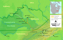
The Wilderness Road was one of two principal routes used by colonial and early national era settlers to reach Kentucky from the East. Although this road goes through the Cumberland Gap into southern Kentucky and northern Tennessee, the other is sometimes called the "Cumberland Road" because it started in Fort Cumberland in Maryland. Despite Kentucky Senator Henry Clay's advocacy of this route, early in the 19th century, the northern route was selected for the National Road, connecting near Washington, Pennsylvania into the Ohio Valley of northern Kentucky and Ohio.

Kentucky County, later the District of Kentucky, was formed by the Commonwealth of Virginia from the western portion of Fincastle County effective 1777. The name of the county was taken from a Native American place name that came to be associated with a river in east central Kentucky, and gave the Kentucky River its name and eventually the U.S. state of Kentucky. During the almost four years of Kentucky County's existence, its seat of government was Harrodstown.

The Overmountain Men were American frontiersmen from west of the Blue Ridge Mountains which are the leading edge of the Appalachian Mountains, who took part in the American Revolutionary War. While they were present at multiple engagements in the war's southern campaign, they are best known for their role in the American victory at the Battle of Kings Mountain in 1780. The term "overmountain" arose because their settlements were west of, or "over", the Blue Ridge, which was the primary geographical boundary dividing several of the 13 American states from the Native American lands to the west. The Overmountain Men hailed from parts of Virginia, North Carolina, and what is now Tennessee and Kentucky.

The Watauga Association was a semi-autonomous government created in 1772 by frontier settlers living along the Watauga River in what is now Elizabethton, Tennessee. Although it lasted only a few years, the Watauga Association provided a basis for what later developed into the state of Tennessee and likely influenced other western frontier governments in the trans-Appalachian region. North Carolina annexed the Watauga settlement area, by then known as the Washington District, in November 1776. Within a year, the area was placed under a county government, becoming Washington County, North Carolina, in November 1777. This area covers the present day Washington County, Carter County, and other areas now located in the northeast part of the state of Tennessee.

Fort Nashborough, also known as Fort Bluff, Bluff Station, French Lick Fort, Cumberland River Fort and other names, was the stockade established in early 1779 in the French Lick area of the Cumberland River valley, as a forerunner to the settlement that would become the city of Nashville, Tennessee. The fort was not a military garrison. The log stockade was square in shape and covered 2 acres (8,100 m2). It contained 20 log cabins and was protection for the settlers against wild animals and Indians. James Robertson and John Donelson are considered the founders, and colloquially, the "founders of Tennessee". The fort was abandoned in 1794, but the settlement, now the city of Nashville, became the capital of the new state of Tennessee in 1843.

Richard Henderson was an American jurist, land speculator and politician who was best known for attempting to create the Transylvania Colony in frontier Kentucky. Henderson County and its seat Henderson, Kentucky are named for him. He also sold land to an early settlement that went on to become Nashville, Tennessee.

The siege of Boonesborough was a military engagement which took place in September 1778 during the American Revolutionary War. On September 7, Shawnee chief Blackfish, who was allied to the British, led an attack on the Kentucky settlement of Boonesborough. Months before the battle, Blackfish had captured and adopted Daniel Boone, the founder of Boonesborough. Boone escaped the Shawnees in time to lead the defense of the settlement. Blackfish's siege was unsuccessful and was lifted after eleven days. Boone was then court-martialed by fellow officers who suspected him of harboring Loyalist sympathies. He was acquitted, but soon left the settlement.

The prehistory and history of Kentucky span thousands of years, and have been influenced by the state's diverse geography and central location. Archaeological evidence of human occupation in Kentucky begins approximately 9,500 BCE. A gradual transition began from a hunter-gatherer economy to agriculture c. 1800 BCE. Around 900 CE, the Mississippian culture took root in western and central Kentucky; the Fort Ancient culture appeared in eastern Kentucky. Although they had many similarities, the Fort Ancient culture lacked the Mississippian's distinctive, ceremonial earthen mounds.

The Sycamore Shoals of the Watauga River, usually shortened to Sycamore Shoals, is a rocky stretch of river rapids along the Watauga River in Elizabethton, Tennessee. Archeological excavations have found Native Americans lived near the shoals since prehistoric times, and Cherokees gathered there. As Europeans began settling the Trans-Appalachian frontier, the shoals proved strategic militarily, as well as shaped the economies of Tennessee and Kentucky. Today, the shoals are protected as a National Historic Landmark and are maintained as part of Sycamore Shoals State Historic Park.

The Cherokee–American wars, also known as the Chickamauga Wars, were a series of raids, campaigns, ambushes, minor skirmishes, and several full-scale frontier battles in the Old Southwest from 1776 to 1794 between the Cherokee and American settlers on the frontier. Most of the events took place in the Upper South region. While the fighting stretched across the entire period, there were extended periods with little or no action.

"Indian Reserve" is a historical term for the largely uncolonized land in North America that was claimed by France, ceded to Great Britain through the Treaty of Paris (1763) at the end of the Seven Years' War—also known as the French and Indian War—and set aside for the First Nations in the Royal Proclamation of 1763. The British government had contemplated establishing an Indian barrier state in a portion of the reserve west of the Appalachian Mountains, bounded by the Ohio and Mississippi rivers and the Great Lakes. British officials aspired to establish such a state even after the region was assigned to the United States in the Treaty of Paris (1783) ending the American Revolutionary War, but abandoned their efforts in 1814 after losing military control of the region during the War of 1812.

Sycamore Shoals State Historic Park is a state park located in Elizabethton, in the U.S. state of Tennessee. The park consists of 70 acres (28.3 ha) situated along the Sycamore Shoals of the Watauga River, a National Historic Landmark where a series of events critical to the establishment of the states of Tennessee and Kentucky, and the settlement of the Trans-Appalachian frontier in general, took place. Along with the historic shoals, the park includes a visitor center and museum, the reconstructed Fort Watauga, the Carter House and Sabine Hill . For over a thousand years before the arrival of European explorers, Sycamore Shoals and adjacent lands had been inhabited by Native Americans. The first permanent European settlers arrived in 1770, and established the Watauga Association—one of the first written constitutional governments west of the Appalachian Mountains—in 1772. Richard Henderson and Daniel Boone negotiated the Treaty of Sycamore Shoals in 1775, which saw the sale of millions of acres of Cherokee lands in Kentucky and Tennessee and led to the building of the Wilderness Road. During the American Revolution, Sycamore Shoals was both the site of Fort Watauga, where part of a Cherokee invasion was thwarted in 1776, and the mustering ground for the Overmountain Men in 1780.
The Cherokee have participated in over forty treaties in the past three hundred years.

The Path Grant Deed is a document regarded as a first step toward the American westward migration across the Appalachian Mountains, resulting from negotiations at Sycamore Shoals in March 1775. The land acquired within the boundaries of the Path Grant allowed Daniel Boone to develop the Wilderness Road free from attack or claims by the Cherokee. The Path Grant was recorded on November 15, 1794, by the Hawkins County, Tennessee registrar in Deed Book #1, pages 147-151

The Great Grant Deed, also known as The Great Grant, was a transaction for the sale of property by the Cherokee Nation to Richard Henderson and Company. The grant is also known as the Louisa purchase or the Transylvania purchase. The transaction occurred at Sycamore Shoals on the Watauga River on March 17, 1775. The Great Grant was for lands forming Henderson's new Transylvania Colony comprising much of what is now the state of Kentucky.
The Jacob Brown Grant Deeds, also known more simply as the Nolichucky Grants, were transactions for the sale of land by the Cherokee Nation to Jacob Brown. The transaction occurred at Sycamore Shoals on the Watauga River on March 25, 1775. The Jacob Brown grants were for two large tracts along the Nolichucky River some of which had been previously leased from the Cherokee.

The Charles Robertson Grant, also known more simply as the Watauga Grant, was a transaction for the sale of land by the Cherokee Nation to Charles Robertson. The transaction occurred at Sycamore Shoals on the Watauga River on March 19, 1775. The Charles Robertson Grant was for a large tract in what is now East Tennessee and Western North Carolina, some of which had been previously leased from the Cherokee.