Icehouse Bottom

Last updated

Icehouse Bottom Site
Icehouse-bottom-excavations-tn1.jpg
Excavation work at the Icehouse Bottom site
Location Monroe County, Tennessee
Nearest city Vonore
Coordinates 35°35′32″N84°11′56″W / 35.59222°N 84.19889°W / 35.59222; -84.19889
Builtcirca 7500 BC
NRHP reference No. 78002615
Added to NRHP1978

Icehouse Bottom is a prehistoric Native American site in Monroe County, Tennessee, located on the Little Tennessee River in the southeastern United States. Native Americans were using the site as a semi-permanent hunting camp as early as 7500 BC, making it one of the oldest-known habitation areas in Tennessee. Analysis of the site's Woodland period (1000 BC - 1000 AD) artifacts shows evidence of an extensive trade network that reached to indigenous peoples in Georgia, North Carolina, and Ohio. This was later an area of known Cherokee settlements, the people encountered by Anglo-European settlers in the 18th and 19th centuries.

Contents

Since 1979, the Icehouse Bottom site has been submerged by Tellico Lake, an impoundment of the Little Tennessee River created by the construction of Tellico Dam. Excavations were conducted at the site in the early 1970s prior to dam construction, in anticipation of inundation. Tellico Lake was developed by and is managed by the Tennessee Valley Authority, and the shoreline immediately above the Icehouse Bottom site is part of the McGhee-Carson Unit of the Tellico Lake Wildlife Management Area, which is managed by the Tennessee Wildlife Resources Agency.

Geography

The now-submerged Icehouse Bottom site Icehouse-bottom-tennessee2.jpg
The now-submerged Icehouse Bottom site

The Little Tennessee River enters Monroe County from the east, through a water gap between the Great Smoky Mountains and the Unicoi Mountains. It winds westward for some 40 miles (64 km) before emptying into the Tennessee River near Lenoir City. Tellico Lake, created in 1979, covers the lower 33 miles (53 km) of the Little Tennessee and the lower 22 miles (35 km) of the Tellico River.

Icehouse Bottom is an archeological site of ancient human occupation that was located along the south bank of the Little Tennessee. Prior to construction of the dam and creation of Tellico Lake, this site was approximately 21 miles (34 km) above the mouth of the river at its confluence with the Tennessee River, and nearly 2 miles (3.2 km) above the river's confluence with the Tellico River. The site was located immediately downstream from the base of a steep hill known as Rockcrusher Bluff. [1]

The McGhee-Carson Unit of the Tellico Lake Wildlife Management Area includes what was once the top of Rockcrusher Bluff. When Tellico Lake was filled and flooded the area, the bluff became a peninsula. The entrance to McGhee-Carson is located along Tennessee State Route 360 (Citico Road), a few miles south of the road's junction with U.S. Route 411. Carson Road traverses the unit, ending abruptly at the lakeshore above what was once Icehouse Bottom.

History

Modern indication of Icehouse Bottom using part of Henry Timberlake's 1765 map of the valley Timberlake-icehouse-bottom1.jpg
Modern indication of Icehouse Bottom using part of Henry Timberlake's 1765 map of the valley

Although little historical information regarding Icehouse Bottom is available, numerous historical areas later developed within a two-mile (3-km) radius. Fort Loudoun, a frontier fort built in 1756, was located about one mile to the north, and the Tellico Blockhouse, a federal trading outpost built in 1794, was located slightly more than a mile to the northeast. The Overhill Cherokee villages of Tomotley and Toqua were located opposite Rockcrusher Bluff to the south. The Overhill village of Tuskegee, which is best known as the birthplace of the Cherokee scholar Sequoyah, was located northwest of the Icehouse Bottom site.

In 1819, the Cherokee sold the Overhill territory south of the Little Tennessee River, which included all of what is now Monroe County, to the United States government. Shortly thereafter, an early settler known as "Pioneer" John McGhee purchased several thousand acres along the Little Tennessee River, including the Icehouse Bottom site. He developed some plantations in the area. By the early 20th century the Icehouse Bottom site was within the boundaries of a tobacco farm owned by John Carson. [2] Carson's family owned the land when the Tennessee Valley Authority began buying property along the river for the creation of the Tellico Reservoir. [3]

Although it is unclear how Icehouse Bottom got its name, historian Carson Brewer wrote of a McGhee family story that recalled an "ice-house" located in the 19th century on their lands in the Little Tennessee Valley. According to Brewer, a hole about 30 feet (9.1 m) in circumference would be dug in winter, and ice would be cut from the river or a frozen stream, placed in the hole, and covered with sand. This preserved the ice through the following summer. [4]

Archaeology

In 1967, the Tennessee Valley Authority began construction on Tellico Dam at the mouth of the Little Tennessee; it purchased some 22,000 acres (89 km2) along the river's shoreline. That same year, the University of Tennessee Department of Anthropology, under contract with the National Park Service, began a survey of the valley to determine its archaeological resources and to select sites for excavation prior to inundation. Although project members initially were given two years before the dam was expected to become operational, litigation over environmental concerns pushed the dam's operational date to 1979.

This allowed for much more extensive archaeological work at the Little Tennessee Valley sites, which was important when their great age became known. [5] Excavations were carried out at Icehouse Bottom in 1969, 1970, 1971, and 1977. [6] [7] The site's location in the river's flood plain meant that each heavy rain had added a fresh layer of earth to the site, making it easy to stratify. [8]

Archaic period inhabitants

Burnt rocks from an Archaic period hearth at Icehouse Bottom Icehouse-bottom-burnt-rocks-tn1.jpg
Burnt rocks from an Archaic period hearth at Icehouse Bottom

The 1969-71 excavations uncovered the charred remains of numerous clay hearths situated along the river. Radiocarbon dating has established the date of the earliest of these hearths at around 7500 BC, during the Early Archaic period (8000-6000 BC). This is one of the oldest-known semi-permanent habitation sites within the boundaries of present-day Tennessee. Some of these hearths still displayed impressions made by netting or basketry resting on the clay while it was still moist. [9] Other Archaic-period artifacts uncovered at Icehouse Bottom include a unique type of Early Archaic bifurcate projectile point and Late Archaic (3000-1000 BC) netsinkers. [10]

Throughout the Archaic period, Icehouse Bottom was likely used as a "base camp" and occupied by indigenous peoples on a seasonal or other semi-permanent basis. The camp consisted of several dozen dwellings that were built along several hundred feet along the river terrace. Rockcrusher Bluff contains various outcroppings of chert, which would have been sought for use in making tools and weapons. [11] The early inhabitants of Icehouse Bottom had a diet primarily of white-tailed deer, black bear, acorns, and hickory nuts. They also hunted and ate smaller animals, including squirrel and rabbit. [12]

Woodland period inhabitants

The Woodland-period (1000 BC-1000 AD) material recovered is notable primarily for the presence of maize, an important crop cultivated by indigenous peoples, that dates to as early as 100 AD. Because maize could be grown and stored, it supported increases in population density and the development of centers with a variety of skilled artisans. The Woodland period materials also include non-local pottery sherds, attesting to the people being part of a large trading network. Pottery fragments show that the site's inhabitants were interacting with people of other Middle Woodland sites around the region, including the Hopewell people of the Ohio valley. [13] [14] Woodland-period human burials and cremations have frequently been found in the Icehouse Bottom vicinity. [15]

Icehouse Bottom may have been a manufacturing center of sorts during the Middle Woodland period. Sherds confirm a trade network that included not only the Hopewell centers, but also the Sylva and Garden Creek areas of North Carolina, the McMahan Indian Mounds a few miles to the east in what is now Sevierville, and sites as far away as Georgia. Several sherds uncovered at the Hopewell site in Ohio were probably manufactured at Icehouse Bottom. Icehouse Bottom may have also served as a regional distribution center for mica. The site appeared to have declined in use after the Middle Woodland period, although a few fragments indicative of the early Mississippian period have been found. [16] [17]

Related Research Articles

<span class="mw-page-title-main">Monroe County, Tennessee</span> County in Tennessee, United States

<span class="mw-page-title-main">Loudon County, Tennessee</span> County in Tennessee, United States

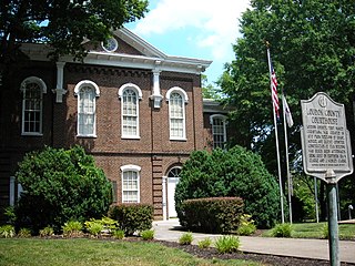
Loudon County is a county in the U.S. state of Tennessee. It is located in the central part of East Tennessee. As of the 2020 census, the population was 54,886. Its county seat is Loudon. Loudon County is included in the Knoxville, TN Metropolitan Statistical Area.

<span class="mw-page-title-main">Vonore, Tennessee</span> Town in Tennessee, United States

Vonore is a town in Monroe County, Tennessee, which is located on the southeast border of the state. The population was 1,574 as of the 2020 census. The city hall, library, community center, police department, and fire department are located on Church Street.

<span class="mw-page-title-main">Little Tennessee River</span> River in the United States of America

The Little Tennessee River is a 135-mile (217 km) tributary of the Tennessee River that flows through the Blue Ridge Mountains from Georgia, into North Carolina, and then into Tennessee, in the southeastern United States. It drains portions of three national forests— Chattahoochee, Nantahala, and Cherokee— and provides the southwestern boundary of the Great Smoky Mountains National Park.

<span class="mw-page-title-main">Tuskegee (Cherokee town)</span> Former Overhill Cherokee town in Monroe County, Tennessee

<span class="mw-page-title-main">Chota (Cherokee town)</span> United States historic place

Chota is a historic Overhill Cherokee town site in Monroe County, Tennessee, in the southeastern United States. Developing after nearby Tanasi, Chota was the most important of the Overhill towns from the late 1740s until 1788. It replaced Tanasi as the de facto capital, or 'mother town' of the Cherokee people.

<span class="mw-page-title-main">Tanasi</span> Historic Cherokee village in Tennessee, USA

Tanasi was a historic Overhill settlement site in present-day Monroe County, Tennessee, in the southeastern United States. The village became the namesake for the state of Tennessee. It was abandoned by the Cherokee in the 19th century for a rising town whose chief was more powerful. Tanasi served as the de facto capital of the Overhill Cherokee from as early as 1721 until 1730, when the capital shifted to Great Tellico.

<span class="mw-page-title-main">Morganton, Tennessee</span> Former town in Tennessee, United States

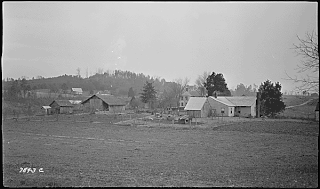
Morganton was a community that developed on the Little Tennessee River in Loudon County, Tennessee, in the southeastern United States. It was located 13.7 miles (22.0 km) above the mouth of the river at its confluence with Bakers Creek, flowing westward from Maryville. During its heyday in the 19th century, Morganton thrived as a flatboat port and regional business center. An important ferry operated at Morganton for nearly 170 years providing service across the river. The abandoned townsite was submerged in the late 20th century by creation of Tellico Lake, part of the Tellico Dam hydroelectric project completed in 1979 by the Tennessee Valley Authority (TVA).

The Bat Creek inscription is an inscribed stone tablet found by John W. Emmert on February 14, 1889. Emmert claimed to have found the tablet in Tipton Mound 3 during an excavation of Hopewell mounds in Loudon County, Tennessee. This excavation was part of a larger series of excavations that aimed to clarify the controversy regarding who is responsible for building the various mounds found in the Eastern United States.

<span class="mw-page-title-main">Tellico Blockhouse</span> United States historic place

The Tellico Blockhouse was an early American outpost located along the Little Tennessee River in what developed as Vonore, Monroe County, Tennessee. Completed in 1794, the blockhouse was a US military outpost that operated until 1807; the garrison was intended to keep peace between the nearby Overhill Cherokee towns and encroaching early Euro-American pioneers in the area in the wake of the Cherokee–American wars.

<span class="mw-page-title-main">Overhill Cherokee</span> 18th century Cherokee people who lived on the west side of the Appalachian Mountains

Overhill Cherokee was the term for the Cherokee people located in their historic settlements in what is now the U.S. state of Tennessee in the Southeastern United States, on the western side of the Appalachian Mountains. This name was used by 18th-century European traders and explorers from British colonies along the Atlantic coast, as they had to cross the mountains to reach these settlements.

<span class="mw-page-title-main">Toqua (Tennessee)</span> Prehistoric Native American site in Monroe County, Tennessee, United States

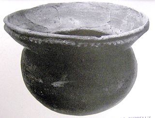
Toqua was a prehistoric and historic Native American site in Monroe County, Tennessee, located in the Southeastern Woodlands. Toqua was the site of a substantial ancestral town that thrived during the Mississippian period. Toqua had a large earthwork 25-foot (7.6 m) platform mound built by the town's Mississippian-era inhabitants, in addition to a second, smaller mound. The site's Mississippian occupation may have been recorded by the Spanish as the village of Tali, which was documented in 1540 by the Hernando de Soto expedition. It was later known as the Overhill Cherokee town Toqua, and this name was applied to the archeological site.

<span class="mw-page-title-main">Tomotley</span> United States historic place

Tomotley is a prehistoric and historic Native American site along the lower Little Tennessee River in Monroe County, Tennessee, in the southeastern United States. Occupied as early as the Archaic period, the Tomotley site was occupied particularly during the Mississippian period, which was likely when its earthwork platform mounds were built. It was also occupied during the eighteenth century as a Cherokee town. It revealed an unexpected style: an octagonal townhouse and square or rectangular residences. In the Overhill period, Cherokee townhouses found in the Carolinas in the same period were circular in design, with,

<span class="mw-page-title-main">Citico (Cherokee town)</span> Historic site near Chattanooga, Tennessee

Citico is a prehistoric and historic Native American site in Monroe County, Tennessee, in the southeastern United States. The site's namesake Cherokee village was the largest of the Overhill towns, housing an estimated Indian population of 1,000 by the mid-18th century. The Mississippian village that preceded the site's Cherokee occupation is believed to have been the village of "Satapo" visited by the Juan Pardo expedition in 1567.

<span class="mw-page-title-main">Chilhowee (Cherokee town)</span> Cherokee village site in Blount and Monroe Counties, Tennessee

<span class="mw-page-title-main">Mialoquo (Cherokee town)</span> United States historic place

Mialoquo is a prehistoric and historic Native American site in Monroe County, Tennessee, in the southeastern United States. The site saw significant periods of occupation during the Mississippian period and later as a Cherokee refugee village. While the archaeological site of Mialoquo was situated on the southwest bank of the Little Tennessee River, the village's habitation area probably included part of Rose Island, a large island in the river immediately opposite the site. Rose Island was occupied on at least a semi-permanent basis as early as the Middle Archaic period.

<span class="mw-page-title-main">Tallassee (Cherokee town)</span> Native American settlement

Carson Brewer was an American journalist and conservationist, best known for his work documenting the folk life of Knoxville and the surrounding Appalachian communities in East Tennessee. During his 40-year career as a columnist for the Knoxville News-Sentinel, Brewer was a key voice for the promotion and protection of the region's natural wonders, especially the Great Smoky Mountains. His historical work included the first extensive history of the Little Tennessee River valley and one of the first comprehensive histories of the Tennessee Valley Authority.

<span class="mw-page-title-main">Bussell Island</span> United States historic place

Bussell Island, formerly Lenoir Island, is an island located at the mouth of the Little Tennessee River, at its confluence with the Tennessee River in Loudon County, near the U.S. city of Lenoir City, Tennessee. The island was inhabited by various Native American cultures for thousands of years before the arrival of early European explorers. The Tellico Dam and a recreational area occupy part of the island. Part of the island was added in 1978 to the National Register of Historic Places for its archaeological potential.

Jefferson Chapman is an archaeologist who conducted extensive excavations at sites in eastern Tennessee, recovering evidence that provided the first secure radiocarbon chronology for Early and Middle Archaic period assemblages in Eastern North America. He also is a research professor in anthropology and the Director of the Frank H. McClung Museum at the University of Tennessee, Knoxville. Chapman’s professional interests include Southeastern archaeology, paleoethnobotany, museology and public archaeology.

References

  1. Jefferson Chapman, The Icehouse Bottom Site 40MR23. Report of Investigations No. 13 (Knoxville, Tenn.: University of Tennessee Department of Anthropology, 1973), 1.
  2. Alberta and Carson Brewer, Valley So Wild (Knoxville: East Tennessee Historical Society, 1975), 88-90, 271-278.
  3. Chapman, The Icehouse Bottom Site 40MR23, 1.
  4. Brewer and Brewer, Valley So Wild, 91.
  5. Richard Polhemus, The Toqua Site 40MR6 Vol. 1 (Knoxville, Tenn.: Tennessee Valley Authority, 1987), 1-2.
  6. Chapman, The Icehouse Bottom Site 40MR23, 4-11.
  7. Patricia Cridlebaugh, The Icehouse Bottom Site (40MR23): 1977 Excavations. Report of Investigations No. 34 (Knoxville, Tenn.: Tennessee Valley Authority, 1981).
  8. Brian Fagan, Ancient North America (Thames and Hudson Ltd., 2005).
  9. Jefferson Chapman, Tellico Archaeology: 12,000 Years of Native American History (Knoxville, Tenn.: Tennessee Valley Authority, 1985), 41.
  10. Chapman, The Icehouse Bottom Site 40MR23, 21.
  11. Chapman, Tellico Archaeology: 12,000 Years of Native American History, 40-41.
  12. Fagan, Ancient North America.
  13. Chapman, Tellico Archaeology: 12,000 Years of Native American History, 58-59, 125.
  14. James Stoltman, "Icehouse Bottom and the Hopewell Connection Archived 2008-07-23 at the Wayback Machine ." Frank H. McClung Museum Research Notes, 17 (February 1999). Retrieved: 29 January 2008.
  15. Chapman, Tellico Archaeology: 12,000 Years of Native American History, 47.
  16. Chapman, Tellico Archaeology: 12,000 Years of Native American History, 70-73.
  17. Stoltman, "Icehouse Bottom and the Hopewell Connection Archived 2008-07-23 at the Wayback Machine ," (February 1999).