Baum Site

Last updated

Baum Site
Nearest cityAydlett, NC Poplar Branch, North Carolina
Area5 acres (2.0 ha)
NRHP reference No. 80002818 [1]
Added to NRHPDecember 8, 1980

The Baum Site (31Ck9) is one of the most prominent Middle and Late Woodland Period sites of the Colington Phase in the state of North Carolina. It is located north of Poplar Branch in Currituck County, North Carolina. This phase, marked by cultures of the Algonkian peoples, aligns with the Late Woodland period in North Carolina, occurring during English explorations between 1584 and 1587, and permanent settlement at 1650. [2] This village is what the first English explorers encountered when entering the coastal region. The site contained ossuaries and evidence for a coastal village adaptation. The site was registered with the National Register of Historic Places on December 8, 1982, after testing and excavations in 1972 and 1973 by David Sutton Phelps, who was an archaeologist at East Carolina University. The site is suffering from erosion due to wave action. After the initial discovery, which was the result of erosion uncovering of remains, Phelps claimed, “this will provide the first glimpse of a coastal village of this type in the state”. [3] A residential subdivision, Currituck Crossing, is now located on the Baum site. https://web.archive.org/web/20160617035403/http://co.currituck.nc.us/pdf/board-of-commissioners-minutes-2013/boc-minutes-13nov04.pdf.

Contents

Geography

The site is 5 acres of Norfolk loamy fine sand, found north of Poplar Branch, a small town in North Carolina. Currituck Sound, a canal, and a farm pond surround it. The Baum site has a rolling topography with two ridges, one running parallel to the coast. [4]

Excavations

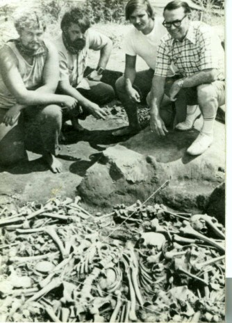
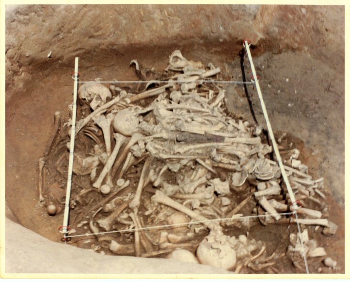
After a survey in the mid-1950s of Currituck County, East Carolina University conducted a study of the area known as the Baum Site after reports of exposed bone along the beach. [5] During this early excavation, the focus was mainly on developing a basic stratigraphy and context. Milford Baum, whom the site is named after, allowed Phelps and colleagues to conduct research on the area since the already found remains showed significant evidence of Algonkian and Woodland occupation. An ossuary was found, known as Burial 1, which had the remains of 58 individuals, several of which were articulated. [6] Although there was another burial found first, Feature 1, it only contained traces of a pit, which did not warrant an excavation. Many of the remains were well preserved due to the presence of oyster shells, which acted as acid-neutralizing agents in the soil. [3] The excellent preservation allowed Phelps and his team to make numerous interpretations regarding dating, culture, and modes of subsistence.

In 1980, another survey was conducted when another burial was found, due to erosion. This burial, known as Burial 5 ossuary, contained around 30 individuals, with one of the individuals being in an upper pit. [7] These findings confirm a presence of Native Americans during the Colington Phase.

The site had been regarded as a very important shell midden site in the state of North Carolina for decades. It has been used for research and investigation several times, including in 2005, when archaeologists from the Office of State Archaeology found remains that were uncovered by erosion at the bluff area of the site. [8]

Coastal Carolina Research, Inc. conducted another investigation in 2006 “…in response to a planned development. Limited testing concluded…the development was the fringe of the village. The area was subsequently mitigated through data recovery”. [3]

Artifacts and Interpretations

The ossuaries present at the shell midden site provide important information about Woodland period material culture. Permanent village life is thought to have originated during the Colington Phase locally.

According to the North Carolina Office of State Archaeology, many ceramics, blades, shellfish remains, and other projectile points were recovered from the site. Copper beads and a marginella shell necklace were also found to be linked with the ossuaries. [3] It can be interpreted that the Algonkian Indians who inhabited the Baum site relied heavily on oysters and other marine resources for survival. In Burial 5, the only intentionally deposited artifact was a marginella shell necklace and a disc-shaped copper bead. [9]

During this time period, agriculture was an important source for survival. In the village, corn was a staple, as well as the cultivation of beans and squash. John Noakes and Betty Lee Brandau were able to use radiocarbon dating in order to provide a time of existence of the Woodland Indians. They found that, “Charred juncus grass fragments of woven grass mat upon which lay a cremated burial…[which] partly intruded into an ossuary…Both date from the late Algonkian occupation of the site”. [10] The dating for these artifacts was A.D. 1590 with an error of +/- 65 years. According to the same article, oysters and ceramics from the Baum site were also dated at A.D. 635 with an error of +/- 70 years, a much different date than the burial and grass mat. [10] Based on the cultural pattern, resembling the Algonkian culture, the 3 burials found seem to suggest the first evidence of ‘cemetery areas’. [11] Methods such as these are key for archaeologists and scholars who are attempting to better understand the history of a site.

Problems

Erosion from sea level rising and storms was and continues to be a continual, destructive process on coastal sites, such as Baum. Archaeologists also face difficult issues with time and funding. For example, Burial 1 was discovered in 1973 but was not excavated until 1974, when sufficient resources were available to proceed. [12]

  1. Archaeological Salvage of an Ossuary at the Baum Site by David Sutton Phelps
  2. Southeastern Prehistory Woodland Period
  3. North Carolina State Historic Preservation Office
  4. The Carolina Algonkians
  5. Picture of Milford Baum with Anthropologists at Indian Burial Site
  6. Rethinking Taxonomies: Skeletal Variation on the North Carolina Coastal Plain
  7. Southeastern Prehistory - Woodland Period
  8. The Archaeology of North Carolina: Three Archaeological Symposia
  9. Picture of Native American Burial at Baum Site

Related Research Articles

<span class="mw-page-title-main">Roanoke Island</span> Island in the Outer Banks of North Carolina, United States

Roanoke Island is an island in Dare County, bordered by the Outer Banks of North Carolina. It was named after the historical Roanoke, a Carolina Algonquian people who inhabited the area in the 16th century at the time of English colonization.

<span class="mw-page-title-main">Pinson Mounds</span> Archaeological park

The Pinson Mounds comprise a prehistoric Native American complex located in Madison County, Tennessee, in the region that is known as the Eastern Woodlands. The complex, which includes 17 mounds, an earthen geometric enclosure, and numerous habitation areas, was most likely built during the Middle Woodland period. The complex is the largest group of Middle Woodland mounds in the United States. Sauls' Mound, at 72 feet (22 m), is the second-highest surviving mound in the United States.

<span class="mw-page-title-main">Upper Mississippian culture</span> Archaeological culture in North America

The Upper Mississippian cultures were located in the Upper Mississippi basin and Great Lakes region of the American Midwest. They were in existence from approximately A.D. 1000 until the Protohistoric and early Historic periods.

Garden Creek site is an archaeological site located 24 miles (39 km) west of Asheville, North Carolina in Haywood County, on the south side of the Pigeon River and near the confluence of its tributary Garden Creek. It is near modern Canton and the Pisgah National Forest. The earliest human occupation at the site dates to 8000 BCE. The 12-acre site features remains of two villages (31Hw7) occupied first in the Woodland period and, most prominently, in the Pisgah phase associated with the South Appalachian Mississippian culture. A total of four earthwork mounds have been found at the site; three have been excavated.

The Hobson site (33MS2) is a Native American archaeological site located 1.5 miles (2.4 km) below Middleport, Ohio on the north bank of the Ohio River. It has minor traces of Archaic, Woodland and Late Prehistoric artifacts. However, the largest component is a small village and cemetery of the Feurt Phase of the Fort Ancient culture originally estimated to date to 1100 to 1200 CE. More recent radiocarbon-dating has provided a date of 1350 CE.

<span class="mw-page-title-main">Potomac Creek, 44ST2</span> Archaeological site in Virginia, United States

Potomac Creek, or 44ST2, is a late Native American village located on the Potomac River in Stafford County, Virginia. It is from the Woodland Period and dates from 1300 to 1550. There is another Potomac Creek site, 44ST1 or Indian Point, which was occupied by the Patawomeck during the historic period and is where Captain John Smith visited. This site no longer exists, as it eroded away into the river. Site 44ST2 has five ossuaries, one individual burial, and one multiple burial. Other names for the site are Potowemeke and Patawomeke. The defining features include distinctive ceramics, ossuary burials, and palisade villages.

<span class="mw-page-title-main">Younge site</span> Archaeological site in Michigan, United States

The Younge site is an archeological site located in Goodland Township, Lapeer County, Michigan. It is classified as a prehistoric Late Woodland site and was designated as a Michigan State Historic Site on October 29, 1971. It was added to the National Register of Historic Places on October 29, 1976.

The Chauga Mound (38OC1) is an archaeological site once located on the northern bank of the Tugaloo River, about 1,200 feet (370 m) north of the mouth of the Chauga River in present-day Oconee County, South Carolina. The earthen platform mound and former village site were inundated by creation of Lake Hartwell after construction of the Hartwell Dam on the Savannah River, which was completed in 1962.

David Sutton Phelps Jr. was an American professor and anthropologist. He was born in Fort Pierce, Florida. From 1970–1996 Phelps taught anthropology at East Carolina University, which named an archaeology lab after him. Before teaching at East Carolina University Phelps had taught at Tulane University, Florida State University, and Briefly at the University Of Georgia, respectively in that order.

<span class="mw-page-title-main">Pensacola culture</span> Archaeological culture in the southeastern US

The Pensacola culture was a regional variation of the Mississippian culture along the Gulf Coast of the United States that lasted from 1100 to 1700 CE. The archaeological culture covers an area stretching from a transitional Pensacola/Fort Walton culture zone at Choctawhatchee Bay in Florida to the eastern side of the Mississippi River Delta near Biloxi, Mississippi, with the majority of its sites located along Mobile Bay in the Mobile-Tensaw River Delta. Sites for the culture stretched inland, north into the southern Tombigee and Alabama River valleys, as far as the vicinity of Selma, Alabama.

<span class="mw-page-title-main">Juntunen site</span> Archaeological site in Michigan, United States

The Juntunen site, also known as 20MK1, is a stratified prehistoric Late Woodland fishing village located on the western tip of Bois Blanc Island. It was listed on the National Register of Historic Places in 1978.

<span class="mw-page-title-main">Alepotrypa Cave</span> Cave and archaeological site in the Mani region of the Peloponnese peninsula of Greece

The Alepotrypa Cave is an archaeological site in the Mani region of the Peloponnese peninsula. In addition to being inhabited by early farmers, this site was used for burial and cult purposes. Archaeological evidence has revealed that this is one of the largest Neolithic burial sites ever found in Europe. Two adult human skeletons were found at the site from a burial dating to the 4th millennium BC, as well as remains from at least 170 separate persons. Archaeologists are uncertain about the significance of a Mycenaen ossuary, which has been dated to the 2nd millennium BC and appears to have been reburied at Alepotrypa. While there is no direct evidence, it is possible that the ossuary may link Alepotrypa to Tainaron, which was regarded as the entrance to Hades in classical mythology.

The Schwerdt site (20AE127) is located on the Kalamazoo River in Allegan County, Michigan. It is classified as a single-component Berrien phase site dating to the late prehistoric period. The Berrien phase is associated with the late Woodland but also has some Upper Mississippian influences.

The Anker Site (11Ck-21) is located on the Little Calumet River near Chicago, Illinois. It is classified as a late prehistoric site with Upper Mississippian Huber affiliation.

The Fisher Mound Group is a group of burial mounds with an associated village site located on the DesPlaines River near its convergence with the Kankakee River where they combine to form the Illinois River, in Will County, Illinois, about 60 miles southwest of Chicago. It is a multi-component stratified site representing several Prehistoric Upper Mississippian occupations as well as minor Late Woodland and Early Historic components.

The Carcajou Point site is located in Jefferson County, Wisconsin, on Lake Koshkonong. It is a multi-component site with prehistoric Upper Mississippian Oneota and Historic components.

The Lake Phelps Site is an archaeological site containing much evidence of prehistoric occupation. The lake is in North Carolina. Eleven archaeological investigations have been conducted at the lake over a course of 25 years. Altogether the investigations "recovered over 5,000 artifacts and located and documented 23 canoes." Archaeologists were able to analyze and categorize the recovered artifacts into 10 different artifact types. In addition, the archaeologists were able to provide radiocarbon dates to most of the canoes. The result of all of this provided evidence of prehistoric occupation of Lake Phelps that dated from the Late PaleoIndian/Early Archaic period through the Late Woodland period.

The Fort Wayne mound site was a prehistoric burial mound located on the grounds of the Ordinance Department of the former Fort Wayne in Detroit, Michigan. It was one of a series of mounds in Detroit, including the Springwells Mound Group, the Carsten mound and the Great mound at the River Rouge. By the mid-20th century only the Fort Wayne mound was still standing. Today, the remains of the mound—located near Officers' Row—is fenced off to visitors.

Church Rockshelter No.2 site situates near the Watauga River in Watauga County, North Carolina. It locates upstream from its twin site Church Rockshelter No.1 site. The No.2 site is east-southeast facing and includes two rock shelters formed by a Cranberry Gneiss outcrop. There is a lower shelter at the northern end and an upper shelter at the southern end. The site is owned by Charles Church, who discovered the site in the mid-1900s by finding many projectile points on the ground surface. A total of three excavations explored the site in the 1970s, 1975 and 2011 respectively. The site contains primarily stone and ceramic evidence from Early to Late Woodland period.

<span class="mw-page-title-main">Panga ya Saidi</span> Archaeological site in Kenya

Panga ya Saidi is an archaeological cave site located in Kilifi County, southeastern Kenya, about 15 km from the Indian Ocean in the Dzitsoni limestone hills. The cave site has rich archaeological deposits dating to the Middle Stone Age, Later Stone Age, and Iron Age. Excavated deposits preserve an unusually long record of human activities, from around 78,000 years ago until around 400 years ago, a chronology supported by radiocarbon dating and optically stimulated luminescence dating. This sequence puts Panga ya Saidi alongside other key sites such as Enkapune ya Muto, Mumba Rockshelter, and Nasera Rockshelter that are important for understanding the Late Pleistocene and the Middle to Later Stone Age transition in eastern Africa.

References

  1. "National Register Information System". National Register of Historic Places . National Park Service. July 9, 2010.
  2. Phelps, David Sutton, Archaeological Salvage of an Ossuary at the Baum Site, East Carolina University, 1980, p.6.
  3. 1 2 3 4 Indian Burial Site Uncovered in Currituck, Ablemarle Life, 1973.
  4. Phelps, David Sutton, Archaeological Salvage of an Ossuary at the Baum Site, East Carolina University, 1980, p.4
  5. Phelps, David Sutton, Archaeological Salvage of an Ossuary at the Baum Site, East Carolina University, 1980, p.2.
  6. Phelps, David Sutton, Archaeological Salvage of an Ossuary at the Baum Site, East Carolina University, 1980, p.5.
  7. Phelps, David Sutton, Archaeological Salvage of an Ossuary at the Baum Site, East Carolina University, 1980, p.8.
  8. James, Jr., Stephen R. and Andrew D. W. Lydecker, Phase I Terrestrial and Underwater Archaeological Background Study, Mid-Currituck Bridge Study, Currituck and Dare Counties, North Carolina, 2009, Panamerican Consultants, Inc., 2009, p. 28.
  9. Phelps, David Sutton, Archaeological Salvage of an Ossuary at the Baum Site, East Carolina University, 1980, p.11.
  10. 1 2 Noakes, John E. and Betty Lee Brandau, University of Georgia Radiocarbon V, Radiocarbon, Vol. 18:3, 1976, p.369.
  11. Phelps, David Sutton, Archaeological Salvage of an Ossuary at the Baum Site, East Carolina University, 1980, p.14.
  12. Phelps, David Sutton, Archaeological Salvage of an Ossuary at the Baum Site, East Carolina University, 1980, p.4.