| Alternative names | Princess Point culture |
|---|---|
| Period | Middle Woodland to Late Woodland |
| Dates | c. 500 CE – 1000 CE |
| Type site | Princess Point site |
| Followed by | Glen Meyer culture |
| Defined by | David Marvyn Stothers |
The Princess Point complex (also called the Princess Point culture) is an archaeological culture of the Middle to Late Woodland period of northeastern North America.
The complex marked a transition between the latter part of the Middle Woodland period [1] and the early Late Woodland period. [2] One date estimate places the time period of the Princess Point complex as lasting from around 500 CE to around 1000 CE. [3] It later developed into the Glen Meyer culture. [4]
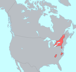
Named for its type site at Princess Point near modern-day Hamilton, Ontario, Canada, the complex was present in the area between the Grand River and the Niagara Peninsula.
It is characterized by a horticultural economy, including the cultivation of maize, as well as aspects of sedentism. [5] It was originally conceptualized by the archaeologist David Marvyn Stothers. [1]
The Princess Point marked a transition to early maize-based agriculture and an increasingly sedentary way of life. Stothers describes Princess Point maize cultivation as "developmental-experimental", [4] and notes the appearance of palisaded agricultural villages containing proto-longhouses. [4] Maize cultivation as a supplement to foraged foods began at least as early as 500 CE. [6] James V. Wright linked the Princess Point culture with the introduction of maize agriculture into Ontario. [7]
There was a general westward geographic shift in focus during this period, with the appearance of sites such as the Glass site (AgHb-5) on the western bank of the Grand River. By the end phase of this Grand River focus, however, occupation had shifted away from river-adjacent floodplains to well-drained sandy hills and plains in modern-day Norfolk County, which were more suitable for maize agriculture. [4]
The Princess Point culture is linked to the introduction of maize to Ontario. [7] This was initially believed in the 1970s to have occurred around AD 650. [8] Later accelerator mass spectrometry (AMS) testing done in the mid-1990s on samples from the Grand Banks site (AfGx-3) returned a calibrated radiocarbon date of AD 540. [8]
David Marvyn Stothers developed the Princess Point complex as an archaeological framework in the late 1960s and early 1970s. His definition of it as a complex was rooted in an understanding of "Princess Point" as being widely distributed; therefore, it was divided into three regional foci (the Point Pelee, Ausable, and Grand River) and three phases falling within an original date range of AD 600 to AD 900. [9]
William Fox later revised this framework, proposing instead that the Princess Point complex should be more narrowly defined around the Grand River focus, with the Ausable focus being excluded as too poorly documented, and the Point Pelee focus assigned to the Riviere au Vase phase of the Western Basin tradition. The timescale was also narrowed to AD 650–900. [9]
Stothers divided the Princess Point complex into a set of three regional foci composed of clusters of similar sites. In a 1973 list, [10] these were:
Grand River focus
Point Pelee focus
Ausable focus
As well, the Forster site is a notable Princess Point site which also contained a Glen Meyer component. [13]

Point Pelee National Park is a national park in Essex County in southwestern Ontario, Canada where it extends into Lake Erie. The word pelée is French for 'bald'. Point Pelee consists of a peninsula of land, mainly of marsh and woodland habitats, that tapers to a sharp point as it extends into Lake Erie. Middle Island, also part of Point Pelee National Park, was acquired in 2000 and is just north of the Canada–United States border in Lake Erie. Point Pelee is the southernmost point of mainland Canada, and is located on a foundation of glacial sand, silt and gravel that bites into Lake Erie. This spit of land is slightly more than seven kilometres long by 4.5 kilometres (2.8 mi) wide at its northern base. Established in 1918, Point Pelee was the first national park in Canada to be established for conservation. It was designated as a Ramsar site on 27 May 1987.

Norfolk County is a rural single-tier municipality on the north shore of Lake Erie in Southwestern Ontario, Canada with a 2023 population of 73,015. Despite its name, it is no longer a county by definition, as all municipal services are handled by a single level of government. The largest community in Norfolk County is Simcoe, whose 2021 population was 16,121. The other population centres are Port Dover, Delhi, Waterford and Port Rowan, and there are many smaller communities. For several years in the late 20th century, the county was merged with Haldimand County but the merged entity was dissolved in 2000.

The Grand River, formerly known as the River Ouse, is a large river in Ontario, Canada. It lies along the western fringe of the Greater Golden Horseshoe region of Ontario which overlaps the eastern portion of southwestern Ontario, sometimes referred to as Midwestern Ontario, along the length of this river. From its source near Wareham, Ontario, it flows south through Grand Valley, Fergus, Elora, Waterloo, Kitchener, Cambridge, Paris, Brantford, Ohsweken, Six Nations of the Grand River, Caledonia, and Cayuga before emptying into the north shore of Lake Erie south of Dunnville at Port Maitland. One of the scenic and spectacular features of the river is the falls and Gorge at Elora.

The Three Sisters are the three main agricultural crops of various indigenous peoples of Central and North America: squash, maize ("corn"), and climbing beans. In a technique known as companion planting, the maize and beans are often planted together in mounds formed by hilling soil around the base of the plants each year; squash is typically planted between the mounds. The cornstalk serves as a trellis for climbing beans, the beans fix nitrogen in their root nodules and stabilize the maize in high winds, and the wide leaves of the squash plant shade the ground, keeping the soil moist and helping prevent the establishment of weeds.

Pelee Island is an island in the Canadian province of Ontario. It is located in the western half of Lake Erie. At 42 km2 (16 sq mi), Pelee Island is the largest island in Lake Erie and the southernmost populated point in Canada. An Ontario Historical Plaque was erected by the province to commemorate the development of Pelee Island's role in Ontario's heritage. Nearby Middle Island is the southernmost point of land in Canada.
In the classification of the archaeological cultures of North America, the Archaic period in North America, taken to last from around 8000 to 1000 BC in the sequence of North American pre-Columbian cultural stages, is a period defined by the archaic stage of cultural development. The Archaic stage is characterized by subsistence economies supported through the exploitation of nuts, seeds, and shellfish. As its ending is defined by the adoption of sedentary farming, this date can vary significantly across the Americas.

The Ausable River is a river in southwestern Ontario Canada which empties into Lake Huron at Port Franks, Ontario. The Ausable's initial source is in a moraine near the community of Staffa, Ontario located in the municipality of West Perth, Ontario at a point 334 metres (1,096 ft) above sea level. Although the river has a total measured length of over 240 kilometres (150 mi), because of its meandering course, the mouth in actuality is only 64 kilometres (40 mi) from its source near Staffa. The Ausable drains 1,142 square kilometers (441 sq mi) of land, and falls 158 metres (518 ft) in elevation from source to outlet.
The Carolinian forest refers to a life zone in eastern North America characterized primarily by the predominance of deciduous (broad-leaf) forest. The term "Carolinian", which is most commonly used in Canada, refers to the deciduous forests which span across much of the eastern United States from the North Carolina northward into southern Ontario, Canada. These deciduous forests in the United States and southern Ontario share many similar characteristics and species hence their association. Today the term is often used to refer to the Canadian portion of the deciduous forest region while the portion in the United States is often referred to as the "Eastern deciduous forest".

The Eastern Agricultural Complex in the woodlands of eastern North America was one of about 10 independent centers of plant domestication in the pre-historic world. Incipient agriculture dates back to about 5300 BCE. By about 1800 BCE the Native Americans of the woodlands were cultivating several species of food plants, thus beginning a transition from a hunter-gatherer economy to agriculture. After 200 BCE when maize from Mexico was introduced to the Eastern Woodlands, the Native Americans of the eastern United States and adjacent Canada slowly changed from growing local indigenous plants to a maize-based agricultural economy. The cultivation of local indigenous plants other than squash and sunflower declined and was eventually abandoned. The formerly domesticated plants returned to their wild forms.
The St. Lawrence Iroquoians were an Iroquoian Indigenous people who existed until about the late 16th century. They concentrated along the shores of the St. Lawrence River in present-day Quebec and Ontario, Canada, and in the American states of New York and northernmost Vermont. They spoke Laurentian languages, a branch of the Iroquoian family.
Hay Swamp is a provincially significant wetland complex, 1839 hectares in size, located in parts of the central land areas of the municipalities of Bluewater and South Huron, in southwestern Ontario, Canada. Approximately 13 kilometers (8.1 mi) in length and 2 kilometers (1.2 mi) in width, at its widest point; it consists of 15 extensively forested individual wetlands, situated on either side, of sections of both the upper drainage of the Ausable River and its tributary, Black Creek.

The Point Peninsula complex was an indigenous culture located in Ontario and New York from 600 BCE to 700 CE. Point Peninsula ceramics were first introduced into Canada around 600 BCE then spread south into parts of New England around 200 BCE. Some time between 300 BCE and 1 CE, Point Peninsula pottery first appeared in Maine, and "over the entire Maritime Peninsula." Little evidence exists to show that it was derived from the earlier, thicker pottery, known as Vinette I, Adena Thick, etc... Point Peninsula pottery represented a new kind of technology in North America and has also been called Vinette II. Compared to existing ceramics that were thicker and less decorated, this new pottery has been characterized by "superior modeling of the clay with vessels being thinner, better fired and containing finer grit temper." Where this new pottery technology originated is not known for sure. The origin of this pottery is "somewhat of a problem." The people are thought to have been influenced by the Hopewell traditions of the Ohio River valley. This influence seems to have ended about 250 CE, after which they no longer practiced burial ceremonialism.
The Saugeen complex was a First Nations culture located around the southeast shores of Lake Huron and the Bruce Peninsula, around the London area, and possibly as far east as the Grand River. They were active in the period 200 BCE to 500 CE. Archeological evidence suggests that Saugeen complex people of the Bruce Peninsula may have evolved into the Odawa people (Ottawa).

The Laurel complex or Laurel tradition is an archaeological culture which was present in what is now southern Quebec, southern and northwestern Ontario and east-central Manitoba in Canada, and northern Michigan, northwestern Wisconsin, and northern Minnesota in the United States. They were the first pottery using people of Ontario north of the Trent–Severn Waterway. The complex is named after the former unincorporated community of Laurel, Minnesota. It was first defined by Lloyd Wilford in 1941.
Princess Point is located in the south east corner of Cootes Paradise marsh in Hamilton, Ontario, and is a principal access point to the surrounding natural areas. The property is part of the Cootes Paradise Nature Sanctuary owned and managed by the Royal Botanical Gardens (RBG). The low waterside peninsula next to Chedoke Creek has made Princess Point a natural gathering place for people for thousands of years. Archeological discoveries have indicated that between 1000 and 800 AD the Middle Woodland Culture brought agriculture in the form of corn production to the region. The discovery of this has given rise to the term the Princess Point Complex, referring to this archeological group of First Nations people that cover a large region of eastern North America.

The Younge site is an archeological site located in Goodland Township, Lapeer County, Michigan. It is classified as a prehistoric Late Woodland site and was designated as a Michigan State Historic Site on October 29, 1971. It was added to the National Register of Historic Places on October 29, 1976.

Huronia is a historical region in the province of Ontario, Canada. It is positioned between lakes Simcoe, Ontario, and Huron. Similarly to the latter, it takes its name from the Wendat or Huron, an Iroquoian-speaking people, who lived there from prehistoric times until 1649 during the Beaver Wars when they were defeated and displaced by the Five Nations of the Iroquois who lived in New York.
The Iroquoian peoples are an ethnolinguistic group of peoples from eastern North America. Their traditional territories, often referred to by scholars as Iroquoia, stretch from the mouth of the St. Lawrence River in the north, to modern-day North Carolina in the south.

The Moccasin Bluff site is an archaeological site located along the Red Bud Trail and the St. Joseph River north of Buchanan, Michigan. It was listed on the National Register of Historic Places in 1977, and has been classified as a multi-component prehistoric site with the major component dating to the Late Woodland/Upper Mississippian period.
The Old Ausable Channel is a self-contained waterway in Lambton County, Ontario, Canada that runs through the Pinery Provincial Park and the community of Grand Bend. It is a 14 kilometre long river channel that was isolated from the Ausable River by the digging of canals for drainage in the late nineteenth century. Part of the Pinery Provincial Park's rare oak savanna, the channel is an important part of the region's ecosystem.