Western North Carolina

Last updated
The counties most commonly associated with Western North Carolina. Many definitions will vary. Westernnorthcarolina.png
The counties most commonly associated with Western North Carolina. Many definitions will vary.

Western North Carolina (often abbreviated as WNC) is the region of North Carolina which includes the Appalachian Mountains; it is often known geographically as the state's Mountain Region. It contains the highest mountains in the Eastern United States, with 125 peaks rising to over 5,000 feet (1,500 meters) in elevation. Mount Mitchell at 6,684 feet (2,037 meters), is the highest peak of the Appalachian Mountains and mainland eastern North America. The population of the 23 most commonly associated counties for the region, as measured by the 2020 U.S. Census, is 1,149,405. [1] [2] The region accounts for approximately 11% of North Carolina's total population.

Contents

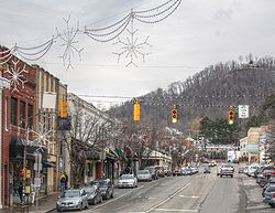
Located east of the Tennessee state line and west of the Piedmont, Western North Carolina contains few major urban centers. Asheville, located in the region's center, is the area's largest city and most prominent commercial hub. The Foothills region of the state is loosely defined as the area along Western North Carolina's eastern boundary; this region consists of a transitional terrain of hills between the Appalachians and Piedmont Plateau of central North Carolina.

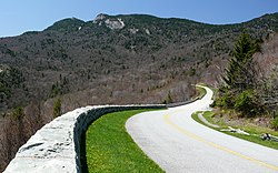
Areas in the northwest portion of the Western North Carolina region, including Boone and Blowing Rock, commonly use the nickname "The High Country". The term Land of the Sky (or Land-of-Sky) is a common nickname for the Asheville area. The term is derived from the title of the novel, Land of the Sky (1876), written by Mrs. Frances Tiernan, under the pseudonym Christian Reid. She often refers in this book to the Great Smoky Mountains and Blue Ridge Mountains, the two main ranges in Western North Carolina. The Asheville area regional government body, the Land-of-Sky Regional Council, uses this nickname.

The federally recognized Eastern Band of Cherokee Indians (EBCI) have a reserve in this region known as Qualla Boundary; it is situated adjacent to the Great Smoky Mountains National Park. Their capital is at Cherokee, North Carolina. This region, taking in today's southeastern Tennessee, western North and South Carolina, and northeastern Georgia, is considered the homeland of the historic Cherokee. Many of the people were forcibly removed in the late 1830s in the Trail of Tears to Indian Territory, but others remained; their descendants make up the EBCI, among the largest of recognized tribes. Sixteen earthwork mounds or their sites, built by indigenous peoples, have been listed in state archeological records in the eleven westernmost counties. Archeological and related research in the early 21st century has revealed that there may be as many as 50 such prehistoric mounds in this area, which were long central to Cherokee towns and culture. [3]

Subregions

Far West

The Biltmore Estate outside Asheville Biltmore Estate.jpg
The Biltmore Estate outside Asheville

The southwestern and far west part of Western North Carolina all lie within the Appalachian Mountain chain. Mt. Mitchell, the highest peak in the state, as well as eastern North America, is located here. Asheville is the major urban hub of far western North Carolina. This area also includes a few hydroelectric projects managed by the Tennessee Valley Authority, including Fontana Dam. Tourism, especially outdoor ventures such as canoeing, whitewater rafting, camping, and fishing are important for many local economies.

High Country

The northern counties in Western North Carolina are commonly known as the state's High Country. [4] Centered on Boone, the High Country has the area's most popular ski resorts, including Ski Beech, Appalachian Ski Mountain, and Sugar Mountain. [5] The area also features such attractions, historical sites, and geological formations as Linville Caverns, Grandfather Mountain, and Blowing Rock. Education, skiing, tourism, and Christmas tree farming are among this area's most prominent industries, although agriculture and raising livestock also remain important. [5] The counties that make up the High Country are: Alleghany, Ashe, Avery, Mitchell, Watauga, Wilkes, and Yancey. [6]

Foothills

View from top of Hibriten Mountain in the Brushy Mountains, showing City of Lenoir below and greater outskirts of Caldwell County City of Lenoir View from Hibriten Mountain.jpg
View from top of Hibriten Mountain in the Brushy Mountains, showing City of Lenoir below and greater outskirts of Caldwell County

The Foothills is a region of transitional terrain between the Piedmont Plateau and the Appalachian Mountains, extending from the lower edge of the Blue Ridge escarpment into the upper Catawba, Yadkin, Broad, Saluda, and Savannah River valleys. The eastern slopes of the Blue Ridge drop sharply to the foothills section, going from 3,500 to 4,000 feet (1,000–1,200 m) at the top to 1,000–1,500 feet at the base. The foothills region contains numerous lower peaks and isolated mountain ranges, such as the South Mountains, Brushy Mountains, and Stone Mountain State Park. The foothills are divided into many small river and creek valleys where much of the region's population lives. Although no large cities are located in the foothills, the subregion contains many smaller cities and towns.

These towns were often developed by European Americans around a single industry, such as furniture or textiles, which depended on local waterpower as their energy sources. In the late 20th century, many of these industries and their associated jobs moved offshore to other countries due to globalization, although they still remain prevalent in some foothill areas. The towns that depended upon them economically, often suffered from job and population losses of people moving to areas of more economic opportunity. Some areas of the foothills have developed newer economies, including manufacturing, food distribution, utilities, and health care. Many farmers in the northern foothills are poultry farmers. Vineyards have also been developed, along with associated winemaking and popular retail.

Among the towns of the foothills region are: Elkin, Forest City, Glen Alpine, Granite Falls, Hudson, Lake Lure, Rutherfordton, Spindale, Tryon, and Valdese; and the cities of Hickory, Lenoir, Marion, Mount Airy, Shelby, and Morganton. "The southern mountains" refer to the counties bordering South Carolina. The cities/towns of Hendersonville, Brevard, and Columbus are within this area.

Higher education

View from Sanford Mall, on campus of Appalachian State University ASU Sanford Mall Winter.JPG
View from Sanford Mall, on campus of Appalachian State University

The region has three major public universities: Appalachian State University in Boone, Western Carolina University in Cullowhee, and UNC Asheville in Asheville. All three are part of the University of North Carolina system.

Several small, private colleges and universities are also located in the region. Mars Hill University is located 15 miles (24 km) north of Asheville. Founded in 1856, it is the oldest college or university in Western North Carolina. Montreat College, affiliated with the Presbyterian Church, is located 15 miles (24 km) east of Asheville. Lees-McRae College, located in Banner Elk, is also affiliated with the Presbyterian Church. Warren Wilson College, located in Swannanoa, is noted for its strong pro-environment policies and for being one of the nine work colleges in the United States. Brevard College, located in Brevard, is affiliated with the United Methodist Church. Lenoir-Rhyne University, located in Hickory, is a private liberal arts university affiliated with the Evangelical Lutheran Church in America.

Several community college systems serve the region, including Asheville-Buncombe Technical Community College, Blue Ridge Community College, Caldwell Community College & Technical Institute, Catawba Valley Community College, Haywood Community College, Isothermal Community College, Mayland Community College, McDowell Technical Community College, Southwestern Community College, Tri-County Community College, Western Piedmont Community College, and Wilkes Community College. [7]

Transportation

Highways

Interstates

Three major Interstate highways cross the region: Interstate 40, which traverses east–west, Interstate 77, which runs north–south through the northeastern section of Western North Carolina, and Interstate 26, which traverses north–south (although it is classified as an east–west highway for most of its route and is signed as such). Interstate 240 is the only auxiliary interstate route in the region, and it serves downtown Asheville.

U.S. Highways

US 421, a multi-lane expressway, is the major highway in the northwestern part of the state. US 19, US 23, US 64, US 74, and US 441 are the major highways in the far western part of the region. US 70 runs east through the area, connecting Hickory and Asheville. US 221 also runs through the area. This highway, which begins in Perry, Florida, connects the town of Rutherfordton to Jefferson. US 321 runs north from Hickory to Watauga and Avery counties before entering Tennessee.

Blue Ridge Parkway

The Blue Ridge Parkway heading towards Grandfather Mountain Blue Ridge Parkway-27527.jpg
The Blue Ridge Parkway heading towards Grandfather Mountain

The Blue Ridge Parkway, a National Scenic Byway that is 469 miles long, runs through western North Carolina, starting in Virginia and ending near the Great Smoky Mountains National Park.

Railroads

Two major class 1 railroads serve the region, CSX and Norfolk Southern. In addition, two tourist railroads also operate in the area, the Tweetsie Railroad theme park and the Great Smoky Mountains Railroad.

Airports

Asheville Regional Airport (AVL), located southeast of the city of Asheville in Fletcher, serves the area with non-stop jet service to Charlotte, North Carolina; LaGuardia Airport in New York City and nearby Newark, New Jersey; Houston, Texas; Atlanta, Georgia; Orlando Sanford International Airport near Orlando, Florida; Philadelphia, Pennsylvania; Detroit, Michigan; and O'Hare International Airport in Chicago, Illinois.

Economy

Tourism is a major part of the economy in the area, which contains half of the Great Smoky Mountains National Park as well as the Nantahala and Pisgah national forests. Several lakes and dams are scattered throughout Western North Carolina, such as Lake Lure and Fontana Dam. Many visitors travel to the region every summer and autumn from major cities to escape hot weather elsewhere and see the leaves change colors. The timber industry is also a major economic sector.

Appalachian Regional Commission

Map showing 2001-2003 ARC economic designations for counties in "Appalachian" North Carolina, including most counties in Western North Carolina. Appalachian-nc-arc-2003.png
Map showing 2001–2003 ARC economic designations for counties in "Appalachian" North Carolina, including most counties in Western North Carolina.

The Appalachian Regional Commission was formed in 1965 to aid economic development in the Appalachian region, which was lagging far behind the rest of the nation on most economic indicators. The Appalachian region, as currently defined by the commission, includes 420 counties in 13 states, including 29 counties in North Carolina. The Commission classifies each county according to five economic qualifications distressed, at-risk, transitional, competitive, or attainment. "Distressed" counties are considered the most economically endangered and "attainment" counties are the most economically prosperous. The three indicators used for such classification are three-year average unemployment rate, market income per capita, and poverty rate. [8]

In 2003, Appalachian North Carolina which included most counties of Western North Carolina and two counties in central North Carolina had a three-year average unemployment rate of 6%, compared with 6.2% statewide and 5.5% nationwide. In 2002, Appalachian North Carolina had a per capita market income of $21,168, compared with $23,443 statewide and $26,420 nationwide. In 2000, Appalachian North Carolina had a poverty rate of 11.7%, compared to 12.3% statewide and 12.4% nationwide.

Only Graham County was designated as "Distressed" in North Carolina. Six Cherokee, McDowell, Mitchell, Rutherford, Swain, and Yancey were designated "at-risk." Forsyth County (which is usually grouped as part of central North Carolina) was the only county given the "attainment" designation. Four Buncombe, Davie, Henderson, and Polk were designated "competitive." Most Western North Carolina counties were designated "transitional," meaning they lagged behind the national average on one of the three key indicators. Graham County had Appalachian North Carolina's highest poverty rating, with 19.5% of its residents living below the poverty line. Forsyth had Appalachian North Carolina's highest per capita income at $26,987. Watauga County's unemployment rate of 2.3% was lowest of all 420 counties in the Appalachian region. [8]

The changes brought by increased tourism and population growth from retirees and persons migrating to the region have been double-edged. Local businesses have benefited from increased economic revenue, but increases in costs of living and loss of natural habitat to development, can degrade the quality of life for which the region has become notable.

Topography

Blue Ridge Mountains as seen from Woolyback Overlook in northern Jackson County Blue Ridge (western North Carolina, USA) 4.jpg
Blue Ridge Mountains as seen from Woolyback Overlook in northern Jackson County

There are 82 mountain peaks between 5,000 and 6,000 feet (1,500 and 1,800 m) in elevation in western North Carolina, and 43 peaks rise to over 6,000 feet (1,800 m). Among the subranges of the Appalachian Mountains located in western North Carolina are the Great Smoky Mountains, Blue Ridge Mountains, South Mountains, Brushy Mountains, Sauratown Mountains, Great Balsam Mountains, Great Craggy Mountains, the Plott Balsams, and the Black Mountains. Mount Mitchell, in the Black Mountains, is, at 6,684 feet (2,037 m), the highest point in eastern North America. [9] Valley and foothills locations typically range from 1,000–2,000 feet (300–610 m) AMSL.

The major rivers in the region include the French Broad River, Nolichucky River, Watauga River, Little Tennessee River, and Hiwassee River flowing into the Tennessee River valley; the New River flowing into the Ohio River valley; and the headwaters and upper valleys of the Catawba River, Yadkin River, Broad River, and Saluda River flowing through the foothills towards the Atlantic. The Eastern Continental Divide runs through the region, dividing Tennessee-bound streams from those flowing through the Carolinas.

Area

Counties

Triple Falls in DuPont State Forest, Transylvania County Triple Falls, North Carolina (8-11-2006).jpg
Triple Falls in DuPont State Forest, Transylvania County

Western North Carolina is generally considered to consist of 23 counties. [10]

The counties commonly included in the region are as follows:

Other counties that fall under various definitions of Western North Carolina include: Alexander County, Catawba County, Cleveland County, Surry County and Yadkin County. When these counties are added, they form a total regional area of roughly 11,750 square miles (30,400 km2). This makes the region roughly the size of Massachusetts.

During the early 1800s the western counties in North Carolina included counties located in the piedmont region, to distinguish them from the eastern counties in North Carolina that were settled earlier. As the western counties became more populated, jurisdictions competed for representation in the North Carolina General Assembly and the Governor's office. [11]

Cities and towns

Downtown Asheville Asheville at dusk.jpg
Downtown Asheville

Listed below are communities often considered to be a part of Western North Carolina:

Over 40,000 inhabitants

  • Asheville
  • Hickory (Located in the North Carolina foothills; contains small amounts of territory in Burke and Caldwell Counties)

Over 10,000 inhabitants

Fewer than 10,000 inhabitants

Looking Glass Rock near Brevard Blueridgeparkwaylookingglassrock.jpg
Looking Glass Rock near Brevard

Important unincorporated communities

See also

Related Research Articles

<span class="mw-page-title-main">Swain County, North Carolina</span> County in North Carolina, United States

Swain County is a county located on the far western border of the U.S. state of North Carolina. As of the 2020 census, the population was 14,117. Its county seat is Bryson City.

<span class="mw-page-title-main">McDowell County, North Carolina</span> County in North Carolina, United States

McDowell County is a county located in the U.S. state of North Carolina. As of the 2020 census, the population was 44,578. Its county seat is Marion.

<span class="mw-page-title-main">Catawba County, North Carolina</span> County in North Carolina, United States

Catawba County is a county in the U.S. state of North Carolina. As of the 2020 census, the population was 160,610. Its county seat is Newton, and its largest community is Hickory.

<span class="mw-page-title-main">Caldwell County, North Carolina</span> County in North Carolina, United States

Caldwell County is a county in the U.S. state of North Carolina. It is located in the foothills of the Blue Ridge Mountains. As of the 2020 census, the population was 80,652. Its county seat is Lenoir. Caldwell County is part of the Hickory-Lenoir-Morganton, NC Metropolitan Statistical Area.

<span class="mw-page-title-main">Geography of North Carolina</span> Geography of the US state of North Carolina

The geography of North Carolina falls naturally into three divisions — the Appalachian Mountains in the west, the central Piedmont Plateau, and the eastern Atlantic Coastal Plain. North Carolina covers 53,819 square miles (139,391 km2) and is 503 miles (810 km) wide by 150 miles (241 km) long. The physical characteristics of the state vary from the summits of the Smoky Mountains, an altitude of near seven thousand feet (2,130 m) in the west, sloping eastward to sea level along the coast and beaches of the Atlantic Ocean.

<span class="mw-page-title-main">Blue Ridge Mountains</span> Mountain range in the Eastern U.S.

The Blue Ridge Mountains are a physiographic province of the larger Appalachian Highlands range. The mountain range is located in the Eastern United States and extends 550 miles southwest from southern Pennsylvania through Maryland, West Virginia, Virginia, North Carolina, South Carolina, Tennessee, and Georgia. The province consists of northern and southern physiographic regions, which divide near the Roanoke River gap. To the west of the Blue Ridge, between it and the bulk of the Appalachians, lies the Great Appalachian Valley, bordered on the west by the Ridge and Valley province of the Appalachian range.

<span class="mw-page-title-main">Great Smoky Mountains</span> American mountain range along North Carolina/Tennessee border

The Great Smoky Mountains are a mountain range rising along the Tennessee–North Carolina border in the southeastern United States. They are a subrange of the Appalachian Mountains and form part of the Blue Ridge Physiographic Province. The range is sometimes called the Smoky Mountains, and the name is commonly shortened to the Smokies. The Smokies are best known as the home of the Great Smoky Mountains National Park, which protects most of the range. The park was established in 1934 and, with over 11 million visits per year, is the most visited national park in the United States.

<span class="mw-page-title-main">East Tennessee</span> Geographic region of Tennessee

East Tennessee is one of the three Grand Divisions of Tennessee defined in state law. Geographically and socioculturally distinct, it comprises approximately the eastern third of the U.S. state of Tennessee. East Tennessee consists of 33 counties, 30 located within the Eastern Time Zone and three counties in the Central Time Zone, namely Bledsoe, Cumberland, and Marion. East Tennessee is entirely located within the Appalachian Mountains, although the landforms range from densely forested 6,000-foot (1,800 m) mountains to broad river valleys. The region contains the major cities of Knoxville and Chattanooga, Tennessee's third and fourth largest cities, respectively, and the Tri-Cities, the state's sixth largest population center.

<span class="mw-page-title-main">Cherokee National Forest</span> National forest in Tennessee and North Carolina

The Cherokee National Forest is a United States National Forest located in the U.S. states of Tennessee and North Carolina that was created on June 14, 1920. The forest is maintained and managed by the United States Forest Service. It encompasses an estimated area of 655,598 acres (2,653.11 km2).

<span class="mw-page-title-main">Clingmans Dome</span> Mountain, highest peak in Tennessee, United States

Clingmans Dome is a mountain in the Great Smoky Mountains of Tennessee and North Carolina in the Southeastern United States. Its name in Cherokee is Kuwahi or Kuwohi, meaning "mulberry place."

<span class="mw-page-title-main">Joara</span> Archaeological site in North Carolina, United States of America

Joara was a large Native American settlement, a regional chiefdom of the Mississippian culture, located in what is now Burke County, North Carolina, about 300 miles from the Atlantic coast in the foothills of the Blue Ridge Mountains. Joara is notable as a significant archaeological and historic site, where Mississippian culture-era and European artifacts have been found, in addition to an earthwork platform mound and remains of a 16th-century Spanish fort.

<span class="mw-page-title-main">Pisgah National Forest</span> National forest in North Carolina

Pisgah National Forest is a National Forest in the Appalachian Mountains of western North Carolina. It is administered by the United States Forest Service, part of the United States Department of Agriculture. The Pisgah National Forest is completely contained within the state of North Carolina. The forest is managed together with the other three North Carolina National Forests from common headquarters in Asheville, North Carolina. There are local ranger district offices located in Pisgah Forest, Mars Hill, and Nebo.

<span class="mw-page-title-main">Black Mountains (North Carolina)</span> Mountain range in western North Carolina, US

The Black Mountains are a mountain range in western North Carolina, in the southeastern United States. They are part of the Blue Ridge Province of the Southern Appalachian Mountains. The Black Mountains are the highest mountains in the Eastern United States. The range takes its name from the dark appearance of the red spruce and Fraser fir trees that form a spruce-fir forest on the upper slopes which contrasts with the brown or lighter green appearance of the deciduous trees at lower elevations. The Eastern Continental Divide, which runs along the eastern Blue Ridge crest, intersects the southern tip of the Black Mountain range.

<span class="mw-page-title-main">Great Indian Warpath</span> Trails in eastern North America used by Native Americans

The Great Indian Warpath (GIW)—also known as the Great Indian War and Trading Path, or the Seneca Trail—was that part of the network of trails in eastern North America developed and used by Native Americans which ran through the Great Appalachian Valley. The system of footpaths extended from what is now upper New York to deep within Alabama. Various Native peoples traded and made war along the trails, including the Catawba, numerous Algonquian tribes, the Cherokee, and the Iroquois Confederacy. The British traders' name for the route was derived from combining its name among the northeastern Algonquian tribes, Mishimayagat or "Great Trail", with that of the Shawnee and Delaware, Athawominee or "Path where they go armed".

<span class="mw-page-title-main">Chilhowee (Cherokee town)</span> Cherokee village site in Blount and Monroe Counties, Tennessee

Chilhowee was a prehistoric and historic Native American site in present-day Blount and Monroe counties in Tennessee, in what were the Southeastern Woodlands. Although now submerged by the Chilhowee Lake impoundment of the Little Tennessee River, the Chilhowee site was home to a substantial 18th-century Overhill Cherokee town. It may have been the site of the older Creek village "Chalahume" visited by Spanish explorer Juan Pardo in 1567. The Cherokee later pushed the Muscogee Creek out of this area.

The Pisgah phase is an archaeological phase of the South Appalachian Mississippian culture in Southeast North America. It is associated with the Appalachian Summit area of southeastern Tennessee, Western North Carolina, and northwestern South Carolina in what is now the United States.

<span class="mw-page-title-main">Piedmont Atlantic megaregion</span> Megaregion of the southeastern USA

The Piedmont Atlantic megaregion is a neologism created by the Regional Plan Association for an area of the Southeastern United States that contains parts of the states of Alabama, Georgia, Tennessee, South Carolina, and North Carolina. The region includes the Atlanta, Birmingham, Charlotte, Memphis, Nashville, Research Triangle (Raleigh-Durham), and Greensboro-Winston-Salem-High Point metropolitan areas. The megaregion generally follows the Interstate 85/20 corridor. According to Georgia Tech, the Piedmont Atlantic represents over 12 percent of the total United States population and covers over 243,000 square miles (630,000 km2) of land.

<span class="mw-page-title-main">Northeast Georgia</span> Region of Georgia in the United States

Northeast Georgia is a region of Georgia in the United States. The northern part is also in the North Georgia mountains or Georgia mountain region, while the southern part is still hilly but much flatter in topography. Northeast Georgia is also served by the Asheville/Spartanburg/Greenville/Anderson market.

<span class="mw-page-title-main">Charlotte metropolitan area</span> Metropolitan area in the United States

The Charlotte metropolitan area, sometimes referred to as Metrolina, is a metropolitan area of the U.S. states of North and South Carolina, containing the city of Charlotte. The metropolitan area also includes the cities of Gastonia, Concord, Huntersville, and Rock Hill as well as the large suburban area in the counties surrounding Mecklenburg County, which is at the center of the metro area. Located in the Piedmont, it is the largest metropolitan area in the Carolinas, and the fourth largest in the Southeastern United States. The Charlotte metropolitan area is one of the fastest growing metropolitan areas in the United States.

<span class="mw-page-title-main">Too-Cowee</span> United States national historic site and former Cherokee town

Too-Cowee, was an important historic Cherokee town located near the Little Tennessee River north of present-day Franklin, North Carolina. It also had a prehistoric platform mound and earlier village built by ancestral peoples. As their expression of public architecture, the Cherokee built a townhouse on top of the mound. It was the place for their community gatherings in their highly decentralized society. The name translates to "pig fat" in English. British traders and colonists referred to Cowee as one of the Cherokee Middle Towns along this river; they defined geographic groupings based in relation to their coastal settlements, such as Charlestown, South Carolina.

References

  1. https://www.census.gov/library/stories/state-by-state/north-carolina-population-change-between-census-decade.html
  2. "Our State Geography". NCPEDIA. Retrieved November 5, 2019.
  3. "WCU Professor Unearths Wealth of Cherokee Culture and History". The Laurel of Asheville. 2018. Retrieved December 2, 2020.
  4. "High Country Host - in North Carolina". High Country Host. Retrieved April 4, 2018.
  5. 1 2 Designs, AppNet. "Boone, Blowing Rock, Banner Elk, Beech Mountain, Western North Carolina Guide". www.highcountryinfo.com. Retrieved April 4, 2018.
  6. "High Country Council of Government" . Retrieved June 13, 2012.
  7. "Main Campuses". NC Community Colleges. December 16, 2013. Retrieved February 18, 2020.
  8. 1 2 Appalachian Regional Commission Online Resource Center. Retrieved: May 15, 2009.
  9. "GNIS Detail - Mount Mitchell". geonames.usgs.gov. Retrieved April 4, 2018.
  10. "Our State Geography". NCPEDIA. Retrieved November 5, 2019.
  11. Cockrell, David L. (2006). "East-West Rivalry". NCPEDIA. Retrieved November 5, 2019.