Cedar Rock, North Carolina

Last updated

Cedar Rock, North Carolina
NCMap-doton-CedarRock.PNG
Location of Cedar Rock, North Carolina
Coordinates: 35°56′36″N81°27′30″W / 35.94333°N 81.45833°W / 35.94333; -81.45833
Country United States
State North Carolina
County Caldwell
Area
[1]
  Total1.14 sq mi (2.95 km2)
  Land1.14 sq mi (2.95 km2)
  Water0.00 sq mi (0.00 km2)
Elevation
[2]
1,171 ft (357 m)
Population
 (2020)
  Total301
  Density263.80/sq mi (101.88/km2)
Time zone UTC-5 (Eastern (EST))
  Summer (DST) UTC-4 (EDT)
ZIP code
28645 [3]
Area code 828
FIPS code 37-11352 [4]
GNIS feature ID2407428 [2]

Cedar Rock is a village in Caldwell County, North Carolina, United States. The population was 300 at the 2010 census. [5]

Contents

Geography

Cedar Rock is located in east-central Caldwell County northeast of Lenoir, the county seat. The village surrounds the Cedar Rock Country Club and climbs the northern slopes of the Brushy Mountains.

According to the United States Census Bureau, the village has a total area of 1.2 square miles (3.0 km2), all land. [5]

Demographics

Historical population
CensusPop.Note
2000 315
2010 300−4.8%
2020 3010.3%
U.S. Decennial Census [6]

2020 census

Cedar Rock racial composition [7]
RaceNumberPercentage
White (non-Hispanic)28494.35%
Asian 10.33%
Other/Mixed 82.66%
Hispanic or Latino 82.66%

As of the 2020 United States census, there were 301 people, 109 households, and 86 families residing in the village.

2000 census

As of the census [4] of 2000, there were 315 people, 123 households, and 110 families residing in the village. The population density was 283.2 inhabitants per square mile (109.3/km2). There were 126 housing units at an average density of 113.3 per square mile (43.7/km2). The racial makeup of the village was 98.41% White, 0.32% Asian, 1.27% from other races. Hispanic or Latino of any race were 0.32% of the population.

There were 123 households, out of which 26.8% had children under the age of 18 living with them, 87.0% were married couples living together, 2.4% had a female householder with no husband present, and 9.8% were non-families. 9.8% of all households were made up of individuals, and 6.5% had someone living alone who was 65 years of age or older. The average household size was 2.56 and the average family size was 2.73.

In the village, the population was spread out, with 19.4% under the age of 18, 4.1% from 18 to 24, 15.9% from 25 to 44, 41.0% from 45 to 64, and 19.7% who were 65 years of age or older. The median age was 50 years. For every 100 females, there were 100.6 males. For every 100 females age 18 and over, there were 92.4 males.

The median income for a household in the village was $116,686, and the median income for a family was $128,975. Males had a median income of $90,950 versus $40,625 for females. The per capita income for the village was $66,022. None of the families and 0.7% of the population were living below the poverty line, including no under eighteens and none of those over 64.

Related Research Articles

<span class="mw-page-title-main">Caldwell, Kansas</span> City in Sumner County, Kansas

Caldwell is a city in Sumner County, Kansas, United States. As of the 2020 census, the population of the city was 1,025.

<span class="mw-page-title-main">Clarks, Louisiana</span> Village in Louisiana, United States

Clarks is a rural village in Caldwell Parish, Louisiana, United States. The population was 1,017 at the 2010 census. Clarks is the largest community by population in Caldwell Parish.

<span class="mw-page-title-main">Cedar Springs, Michigan</span> City in Michigan, United States

Cedar Springs is a city in Kent County in the U.S. state of Michigan. The population was 3,509 at the 2010 census. Cedar Springs is a northern city of the Grand Rapids metropolitan area and is about 20 miles (32.2 km) north of Grand Rapids.

<span class="mw-page-title-main">Jerico Springs, Missouri</span> Village in Missouri, United States

Jerico Springs is a village in Cedar County, Missouri, United States. The population was 160 at the 2020 census.

<span class="mw-page-title-main">Umber View Heights, Missouri</span> Village in Missouri, United States

Umber View Heights is a village in Cedar County, Missouri, United States. The population was 41 at the 2020 census.

<span class="mw-page-title-main">Cedar Hill Lakes, Missouri</span> Village in Missouri, United States

Cedar Hill Lakes is a village in Jefferson County, Missouri, United States. The population was 203 at the 2020 census.

<span class="mw-page-title-main">Cedar Rapids, Nebraska</span> Village in Nebraska, United States

Cedar Rapids is a village in Boone County, Nebraska, United States. The population was 382 at the 2010 census.

<span class="mw-page-title-main">Cedar Creek, Nebraska</span> Village in Nebraska, United States

Cedar Creek is a village in Cass County, Nebraska, United States. The population was 465 at the 2020 census.

<span class="mw-page-title-main">Belden, Nebraska</span> Village in Nebraska, United States

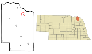
Belden is a village in Cedar County, Nebraska, United States. The population was 112 at the 2020 census.

<span class="mw-page-title-main">Obert, Nebraska</span> Village in Nebraska, United States

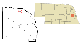
Obert is a village in Cedar County, Nebraska, United States. The population was 23 at the 2020 census.

<span class="mw-page-title-main">Wynot, Nebraska</span> Village in Nebraska, United States

Wynot is a village in Cedar County, Nebraska, United States. The population was 217 at the 2020 census.

<span class="mw-page-title-main">Cedar Bluffs, Nebraska</span> Village in Saunders County, Nebraska, United States

Cedar Bluffs is a village in Saunders County, Nebraska, United States. The population was 615 at the 2020 census. Cedar Bluffs was a point on the Mormon, Oregon, and California Trails.

Northlakes is a census-designated place (CDP) in Caldwell County, North Carolina, United States. It is part of the Hickory–Lenoir–Morganton Metropolitan Statistical Area.

<span class="mw-page-title-main">Cedar Point, North Carolina</span> Town in North Carolina, United States

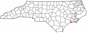
Cedar Point is a town in Carteret County, North Carolina, United States. The population was 1,297 in 2010.

<span class="mw-page-title-main">East Flat Rock, North Carolina</span> Census-designated place in North Carolina, United States

East Flat Rock is an unincorporated area and census-designated place (CDP) in Henderson County, North Carolina, United States. The population was 4,995 at the 2010 census, up from 4,151 at the 2000 census. It is part of the Asheville Metropolitan Statistical Area.

<span class="mw-page-title-main">Chimney Rock, North Carolina</span> Village in North Carolina, United States

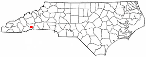
Chimney Rock is a village in Rutherford County, North Carolina, United States. The population was 113 at the 2010 census. The village takes its name from a large granite outcropping located on a summit above the village itself in Chimney Rock State Park.

<span class="mw-page-title-main">South Solon, Ohio</span> Village in Ohio, United States

South Solon is a village in Madison County, Ohio, United States. The population was 329 at the 2020 census. Despite their similar names, South Solon is not adjacent to the city of Solon, Ohio, a suburb of Cleveland in Cuyahoga County. The two towns are approximately 170 miles (270 km) apart.

<span class="mw-page-title-main">Caldwell, Ohio</span> Village in Ohio, United States

Caldwell is a village and the county seat of Noble County, Ohio, United States. It is located along the West Fork of Duck Creek about 23 miles (37 km) north of Marietta. The population was 1,691 at the 2020 census.

Arlington is a town in Columbia County, Wisconsin, United States. The population was 848 at the 2000 census. The Village of Arlington is located within the town.

<span class="mw-page-title-main">Colfax, Wisconsin</span> Village in Wisconsin, United States

Colfax is a village in Dunn County, Wisconsin, United States. The population was 1,158 at the 2010 census. The village is surrounded by the Town of Colfax.

References

  1. "ArcGIS REST Services Directory". United States Census Bureau. Retrieved September 20, 2022.
  2. 1 2 U.S. Geological Survey Geographic Names Information System: Cedar Rock, North Carolina
  3. "Cedar Rock NC ZIP Code". zipdatamaps.com. 2023. Retrieved February 17, 2023.
  4. 1 2 "U.S. Census website". United States Census Bureau . Retrieved January 31, 2008.
  5. 1 2 "Geographic Identifiers: 2010 Demographic Profile Data (G001): Cedar Rock village, North Carolina". U.S. Census Bureau, American Factfinder. Archived from the original on February 12, 2020. Retrieved December 19, 2014.
  6. "Census of Population and Housing". Census.gov. Retrieved June 4, 2015.
  7. "Explore Census Data". data.census.gov. Retrieved December 21, 2021.