Northlakes, North Carolina

Last updated • 2 min readFrom Wikipedia, The Free Encyclopedia

Northlakes, North Carolina
USA North Carolina location map.svg
Red pog.svg
Northlakes
Location within the state of North Carolina
Coordinates: 35°46′32″N81°22′01″W / 35.77556°N 81.36694°W / 35.77556; -81.36694
Country United States
State North Carolina
County Caldwell
Area
[1]
  Total1.91 sq mi (4.94 km2)
  Land1.49 sq mi (3.86 km2)
  Water0.42 sq mi (1.08 km2)
Elevation
[2]
1,073 ft (327 m)
Population
 (2020)
  Total1,543
  Density1,034.18/sq mi (399.31/km2)
Time zone UTC-5 (Eastern (EST))
  Summer (DST) UTC-4 (EDT)
Area code 828
FIPS code 37-47695 [3]
GNIS feature ID2403359 [2]
Website https://northlakeshoa.blogspot.com/

Northlakes is a census-designated place (CDP) in Caldwell County, North Carolina, United States. It is part of the Hickory Lenoir Morganton Metropolitan Statistical Area.

Contents

Geography

Northlakes is located at the southeastern end of Caldwell County. It is bordered to the southeast by Lake Hickory, a reservoir on the Catawba River. The river forms the Caldwell County line, with Burke and Catawba counties on the opposite side.

The city of Hickory is on the opposite side of Lake Hickory and also borders Northlakes to the west. The town of Granite Falls borders Northlakes to the northwest. Along the northern edge of the community is Gunpowder Creek, inundated to form an arm of Lake Hickory.

According to the United States Census Bureau, the CDP has a total area of 1.9 square miles (4.9 km2), of which 1.5 square miles (3.9 km2) is land and 0.4 square miles (1.0 km2), or 21.24%, is water. [4]

Demographics

Historical population
CensusPop.Note
1990 1,219
2000 1,39014.0%
2010 1,53410.4%
2020 1,5430.6%
U.S. Decennial Census [5]

2020 census

Northlakes racial composition [6]
RaceNumberPercentage
White (non-Hispanic)1,38889.95%
Black or African American (non-Hispanic)271.75%
Native American 10.06%
Asian 422.72%
Other/Mixed 473.05%
Hispanic or Latino 382.46%

As of the 2020 United States census, there were 1,543 people, 617 households, and 400 families residing in the CDP.

2000 census

At the time of the 2000 Census, [3] there were 1,390 people, 511 households, and 429 families residing in the CDP. The population density was 932.2 inhabitants per square mile (359.9/km2). There were 535 housing units at an average density of 358.8 per square mile (138.5/km2). The racial makeup of the CDP was 98.27% White, 0.50% African American, 0.22% Native American, 0.22% Asian, 0.22% from other races, and 0.58% from two or more races. Hispanic or Latino of any race were 0.50% of the population.

There were 511 households, out of which 38.9% had children under the age of 18 living with them, 76.1% were married couples living together, 6.3% had a female householder with no husband present, and 15.9% were non-families. 13.3% of all households were made up of individuals, and 4.7% had someone living alone who was 65 years of age or older. The average household size was 2.72 and the average family size was 2.99.

In the CDP, the population was spread out, with 27.3% under the age of 18, 3.6% from 18 to 24, 30.1% from 25 to 44, 29.8% from 45 to 64, and 9.2% who were 65 years of age or older. The median age was 39 years. For every 100 females, there were 98.0 males. For every 100 females age 18 and over, there were 97.8 males.

The median income for a household in the CDP was $67,692, and the median income for a family was $67,237. Males had a median income of $56,429 versus $33,000 for females. The per capita income for the CDP was $27,285. About 1.4% of families and 2.4% of the population were below the poverty line, including 4.7% of those under age 18 and none of those age 65 or over.

Related Research Articles

<span class="mw-page-title-main">Catawba County, North Carolina</span> County in North Carolina, United States

Catawba County is a county in the U.S. state of North Carolina. As of the 2020 census, the population was 160,610. Its county seat is Newton, and its largest community is Hickory.

<span class="mw-page-title-main">Caldwell County, North Carolina</span> County in North Carolina, United States

Caldwell County is a county in the U.S. state of North Carolina. It is located in the foothills of the Blue Ridge Mountains. As of the 2020 census, the population was 80,652. Its county seat is Lenoir. Caldwell County is part of the Hickory-Lenoir-Morganton, NC Metropolitan Statistical Area.

<span class="mw-page-title-main">Blue Ridge, Alabama</span> Census-designated place in Alabama, United States

Blue Ridge is an unincorporated community and census-designated place (CDP) in Elmore County, Alabama, United States. At the 2020 census, the population was 1,485. It is part of the Montgomery Metropolitan Statistical Area.

<span class="mw-page-title-main">Falmouth Foreside</span> Census-designated place in Maine, United States

Falmouth Foreside is a census-designated place (CDP) within the town of Falmouth in Cumberland County, Maine, United States. As of the 2010 census, the CDP population was 1,511. It is part of the Portland–South Portland–Biddeford, Maine Metropolitan Statistical Area.

<span class="mw-page-title-main">Wye, Montana</span> Place in Montana, United States

Wye is an unincorporated community in Missoula County, Montana, United States. It is part of the Missoula, Montana Metropolitan Statistical Area. The population was 511 at the 2010 census, an increase from its population of 381 in 2000. For statistical purposes, the United States Census Bureau has defined Wye as a census-designated place (CDP). Wye is named for the "y"-shaped DeSmet Junction where US 93 and MT 200 met former US 10.

<span class="mw-page-title-main">Bethlehem, Alexander County, North Carolina</span> Census-designated place in North Carolina, United States

Bethlehem is a census-designated place (CDP) in Alexander County, North Carolina, United States. The population was 4,214 at the 2010 census. It is part of the Hickory–Lenoir–Morganton Metropolitan Statistical Area.

<span class="mw-page-title-main">Icard, North Carolina</span> Census-designated place in North Carolina, United States

Icard is a census-designated place (CDP) in Burke County, North Carolina, United States. The population was 2,664 at the 2010 census. It is part of the Hickory–Lenoir–Morganton Metropolitan Statistical Area.

<span class="mw-page-title-main">Gamewell, North Carolina</span> Town in North Carolina, United States

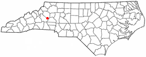
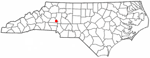
Gamewell is a town in Caldwell County, North Carolina, United States. The population was 4,051 at the 2010 census. It is part of the Hickory–Lenoir–Morganton Metropolitan Statistical Area.

<span class="mw-page-title-main">Granite Falls, North Carolina</span> Town in North Carolina, United States

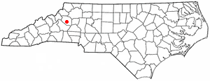
Granite Falls is a town in Caldwell County, North Carolina, United States. The population was 4,722 at the 2010 census. It is part of the Hickory–Lenoir–Morganton Metropolitan Statistical Area.

<span class="mw-page-title-main">Brookford, North Carolina</span> Town in North Carolina, United States

Brookford is a town in Catawba County, North Carolina, United States. The population was 442 at the 2020 census. It is part of the Hickory–Lenoir–Morganton Metropolitan Statistical Area. The Town of Brookford was incorporated March 1, 1907. Brookford began as a mill village, deriving its name from the combination of the two owner's names Holbrook and Shuford. The town has 4.56 miles of roadage.

<span class="mw-page-title-main">Catawba, North Carolina</span> Town in North Carolina, United States

Catawba is a town in Catawba County, North Carolina, United States. The population was 603 at the 2010 census. It is part of the Hickory–Lenoir–Morganton Metropolitan Statistical Area. As with the county, the name recalls the Catawba people, the indigenous people who once inhabited the area.

Lake Norman of Catawba is a census-designated place (CDP) in Catawba County, North Carolina, United States. The population was 11,395 at the 2020 census up from 7,411 at the 2010 census. It is part of the Hickory-Lenoir-Morganton Metropolitan Statistical Area.

<span class="mw-page-title-main">Mountain View, North Carolina</span> Census-designated place in North Carolina, United States

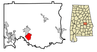
Mountain View is a census-designated place (CDP) in Catawba County, North Carolina, United States. The population was 3,552 at the 2010 census. It is part of the Hickory–Lenoir–Morganton Metropolitan Statistical Area.

<span class="mw-page-title-main">Sherrills Ford, North Carolina</span> Unincorporated community in North Carolina, United States

Sherrills Ford is an unincorporated community and former census-designated place (CDP) in Catawba County, North Carolina, United States. Since the 2010 census, it has been included within the Lake Norman of Catawba CDP. It is part of the Hickory-Lenoir-Morganton Metropolitan Statistical Area.

<span class="mw-page-title-main">St. Stephens, North Carolina</span> Census-designated place in North Carolina, United States

St. Stephens is a census-designated place (CDP) in Catawba County, North Carolina, United States. The population was 8,759 at the 2010 census, down from 9,439 in 2000. It is part of the Hickory–Lenoir–Morganton Metropolitan Statistical Area.

<span class="mw-page-title-main">Northlake, South Carolina</span> CDP in South Carolina, United States

Northlake is a census-designated place (CDP) in Anderson County, South Carolina. The population was 3,818 at the 2020 census.

Elgin is an unincorporated community and census-designated place (CDP) in Lancaster County, South Carolina, United States. The population was 2,607 at the 2010 census.

<span class="mw-page-title-main">Riverview, South Carolina</span> CDP in South Carolina, United States

Riverview is a census-designated place (CDP) in York County, South Carolina, United States, located southwest of Fort Mill along the Catawba River. The population was 708 at the 2000 census.

<span class="mw-page-title-main">Long View, North Carolina</span> Town in North Carolina, United States

Long View is a town in Burke and Catawba counties in the U.S. state of North Carolina. The population was 4,871 at the 2010 census. It is part of the Hickory–Lenoir–Morganton Metropolitan Statistical Area.

<span class="mw-page-title-main">Rhodhiss, North Carolina</span> Town in North Carolina, United States

Rhodhiss is a town in Caldwell and Burke counties in the U.S. state of North Carolina. The population was 1,070 at the 2010 census, up from 366 in 2000. It is part of the Hickory–Lenoir–Morganton Metropolitan Statistical Area.

References

  1. "ArcGIS REST Services Directory". United States Census Bureau. Retrieved September 20, 2022.
  2. 1 2 U.S. Geological Survey Geographic Names Information System: Northlakes, North Carolina
  3. 1 2 "U.S. Census website". United States Census Bureau . Retrieved January 31, 2008.
  4. "Census of Population and Housing". Census.gov. Retrieved June 4, 2016.
  5. "Explore Census Data". data.census.gov. Retrieved December 21, 2021.