Saluda, North Carolina

Last updated

Saluda, North Carolina
Saluda Historic District.jpg
NCMap-doton-Saluda.PNG
Location of Saluda, North Carolina
Coordinates: 35°14′15″N82°20′49″W / 35.23750°N 82.34694°W / 35.23750; -82.34694
Country United States
State North Carolina
Counties Polk, Henderson
Settled1878 [1]
Incorporated1881 [1]
Named for Tsaludiyi (ᏣᎷᏗᏱ) [1]
Area
[2]
  Total1.55 sq mi (4.03 km2)
  Land1.55 sq mi (4.03 km2)
  Water0.00 sq mi (0.00 km2)
Elevation
[3]
2,179 ft (664 m)
Population
 (2020)
  Total631
  Density405.79/sq mi (156.64/km2)
Time zone UTC-5 (Eastern (EST))
  Summer (DST) UTC-4 (EDT)
ZIP code
28773
Area code 828
FIPS code 37-58920 [4]
GNIS feature ID2405410 [3]
Website saluda.com

Saluda is a city in Polk and Henderson counties in the U.S. state of North Carolina. The population was 713 at the 2010 census. [5] Saluda is famous for sitting at the top of the Norfolk Southern Railway's Saluda Grade, which was the steepest main line standard-gauge railway line in the United States until Norfolk Southern ceased operations on the line in 2001. [6] Saluda is close to the South Carolina state line, between Asheville, North Carolina, and Spartanburg, South Carolina.

Contents

History

Saluda's name came from the Cherokee word Tsaludiyi, meaning "green corn place". The first name of the area by European settlers was "Pace's Ridge", from the Pace family who inhabited the area. Many of the original families were Scots-Irish who left Pennsylvania around the time of the Whiskey Rebellion in the early 1790s. [7]

Count Joseph Marie Gabriel St. Xavier de Choiseul, French consul to Charleston, South Carolina, and cousin to Louis Philippe I of France, bought land in 1831 from the Barings of nearby Flat Rock and built his home, Saluda Cottages. [8]

In 1878, there were only two houses in the limits of present-day Saluda. The completion of the Southern Railroad that same year brought about a large change in Saluda. The Saluda railroad grade is unmatched by any main line east of the Rocky Mountains with a grade that drops 600 feet (180 m) to the mile. [7] This included 50 curves, some horseshoe, and saved money by going over rather than through the mountains. [9] This section of railroad was originally built as the Asheville and Spartanburg Railroad. The railroad was built with convict labor, which marked the first such use on a large scale, [10] and was supervised by Colonel Andrew Tanner, who operated the first hotel in Saluda and was elected the first mayor of Saluda in 1881. [7] In 1887, eight passenger trains passed through Saluda daily, with about 3,000 visitors a year. The Saluda Grade was infamous for runaway train accidents. In 1880 alone, fourteen men were killed on the 3-mile (5 km) stretch of track. [11] Freight service along the line ended in December 2001 when Norfolk Southern suspended operations along the line between East Flat Rock, North Carolina and Landrum, South Carolina [12] before severing this segment from the rest of its system in April 2003. [13] Talks to convert this segment to passenger train excursion and a Rails-to-trails conversion made no headway in the 2000s and 2010s. [14] In February 2023, Norfolk Southern agreed to sell 31 miles of the Saluda Grade to the Saluda Grade Trail Conservancy, which plans to convert the segment to a rail trail. [15]

Geography

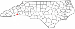
Saluda is located in southwestern Polk County. Two small parts of the city extend west and north into Henderson County. The elevation on Main Street is 2,097 feet (639 m) above sea level, while the elevation at the bottom end of the Saluda Grade, in Tryon, is 1,080 feet (329.1 m).

U.S. Route 176 is Saluda's Main Street; the highway leads east down the mountain 8 miles (13 km) to Tryon and northwest 10 miles (16 km) to Hendersonville. Interstate 26 passes just north of Saluda, with access from Exit 59. I-26 leads north 34 miles (55 km) to Asheville and southeast 37 miles (60 km) to Spartanburg, South Carolina.

According to the United States Census Bureau, Saluda has a total area of 1.5 square miles (4.0 km2), all land. [16]

Geology and seismology

Saluda-area historical earthquake activity is significantly above the North Carolina state average but is 85% smaller than the overall U.S. average.

  1. On November 30, 1973, at 07:48:41, a magnitude 4.7 (4.7 MB, 4.6 ML) earthquake occurred 98.9 miles away from the city center.
  2. On August 2, 1974, at 08:52:09, a magnitude 4.9 (4.3 MB, 4.9 LG, Class: Light, Intensity: IV - V) earthquake occurred 94.8 miles away from the city center.
  3. On August 25, 2005, at 03:09:42, a magnitude 3.6 (3.6 MW, Depth: 5.0 mi, Class: Light, Intensity: II - III) earthquake occurred 51.2 miles away from the city center.
  4. On June 16, 2006, at 00:57:27, a magnitude 3.1 (3.1 LG, Depth: 2.9 mi) earthquake occurred 53.3 miles away from the city center.
  5. On August 4, 2007, at 10:04:46, a magnitude 3.0 (3.0 LG, Depth: 5.8 mi) earthquake occurred 22.7 miles away from the city center.
  6. On December 7, 2007, at 11:07:03, a magnitude 3.1 (3.1 LG, Depth: 3.1 mi) earthquake occurred 10.5 miles away from the city center. [17]

Demographics

Historical population
CensusPop.Note
1900 211
1910 23511.4%
1920 549133.6%
1930 5581.6%
1940 539−3.4%
1950 5471.5%
1960 5704.2%
1970 546−4.2%
1980 60711.2%
1990 488−19.6%
2000 57517.8%
2010 71324.0%
2020 631−11.5%
U.S. Decennial Census [18]

2020 census

Saluda racial composition [19]
RaceNumberPercentage
White (non-Hispanic)57390.81%
Black or African American (non-Hispanic)172.69%
Asian 20.32%
Other/Mixed 223.49%
Hispanic or Latino 172.69%

As of the 2020 United States census, there were 641 people, 369 households, and 231 families residing in the city.

2010 census

As of the 2010 Census, there were 713 people and 493 households with 310 currently occupied, 141 seasonal/recreational/occasional use houses, and 28 for sale/rent. The population density as of the 2000 census, [4] was 369.1 people per square mile (142.3/km2). The racial makeup was 95.65% White, 2.66% African American, 0.28% Asian, 0.28% American Indian and Alaska Native, and 0.98% from two or more races. Hispanic or Latino of any race were 1.96% of the population.

There were 265 households, out of which 20.8% had children under the age of 18 living with them, 52.5% were married couples living together, 7.9% had a female householder with no husband present, and 35.5% were non-families. 31.3% of all households were made up of individuals, and 13.2% had someone living alone who was 65 years of age or older. The average household size was 2.17 and the average family size was 2.70.

The City of Saluda was 43.76% male and 56.24% female. The population was 14.59% under the age of 18. The population over 18 was spread into five categories: 2.52% from age 18 to 24, 4.91% from 25 to 34, 17.11% from 35 to 49, 25.10% from 50 to 60, and 34.90% from age 65 and older. [5]

The median income for a household in the city was $39,063, and the median income for a family was $47,188. Males had a median income of $37,917 versus $25,000 for females. The per capita income for the city was $25,149. About 3.8% of families and 4.6% of the population were below the poverty line, including 3.4% of those under age 18 and 6.1% of those age 65 or over.

Government

The current mayor of Saluda as of 2021 is Tangie Morgan, a native of Saluda and prominent local merchant and civic volunteer. She was first elected in November, 2021. She defeated longtime mayor Fred Baisden by a wide margin.

The city council is composed of the mayor and commissioners: Mark Oxtoby, Stan Walker and Paul Marion.

Attractions

The main street of Saluda is a hub of newly formed restaurants and art galleries. Tourists and cyclists are common on summer and fall weekends due to the many winding mountain roads located around Saluda. The main town festivals are the Saluda Arts Festival, Coon Dog Day, and the Home Town Christmas Celebration. The nearby Green River includes some of the most challenging whitewater in the eastern U.S. and is host to the annual Green River Games kayak race the first weekend in November. [20]

Festivals

The Saluda Arts Festival [21] is an event in which fine artists from all over western North Carolina and South Carolina exhibit and sell oil paintings, watercolors, acrylic paintings and drawings, woodworking, photography, pottery, jewelry, sculptures, stained glass, and metal working. The festival also offers live demonstrations of landscape painting, weaving, pottery, and blacksmithing. It is typically held the third Saturday in May.

The Coon Dog Day festival [21] is one of the oldest festivals in Saluda. It is a homecoming and celebration which includes food, live music, a parade, crafts, and a street dance. The festival also includes a 5k race and a benefit breakfast at the Saluda Masonic Lodge. It is held the first Saturday after July 4 each year.

For the Saluda Home Town Christmas festival, [21] Main Street is decked out in Christmas lights and holiday decorations. Businesses and shops are open and serve holiday refreshments while local musicians perform. The open house and musical events are closed with an ecumenical service delivered by Saluda ministers at the Saluda Presbyterian Church.

Shopping

The majority of shops are located on Main Street. Other businesses are located in Nostalgia Court. [22]

Parks and forests

The Saluda Community Land Trust manages parks and develops trails including the Lazy Girl Loop, Tryon Missing Trace 40, Little Park, and a Community Garden. A small park with a playground and picnic shelter borders the railroad tracks on Main Street. The Saluda Dog Park is on Chestnut Street.

Education

Saluda Elementary is the public elementary school in Saluda, located on Main Street, serving grades pre-kindergarten through 5.

Related Research Articles

<span class="mw-page-title-main">Polk County, North Carolina</span> County in North Carolina, United States

Polk County is a county located in the U.S. state of North Carolina. As of the 2020 census, the population was 19,328. Its county seat is Columbus.

<span class="mw-page-title-main">Gosnell, Arkansas</span> City in Arkansas, United States

Gosnell is a city in northern Mississippi County, Arkansas, United States. The population was 2,910 at the 2020 census, down from 3,548 at the 2010 census.

<span class="mw-page-title-main">Chocowinity, North Carolina</span> Town in North Carolina, United States

Chocowinity is a town in Beaufort County, North Carolina, United States. The population was 820 at the 2010 Census. The town is a part of the Washington Area located in North Carolina's Coastal Plains region.

<span class="mw-page-title-main">Asheville, North Carolina</span> City in North Carolina, United States

Asheville is a city in, and the county seat of, Buncombe County, North Carolina, United States. Located at the confluence of the French Broad and Swannanoa rivers, it is the largest city in Western North Carolina, and the state's 11th-most-populous city. According to the 2020 census, the city's population was 94,589, up from 83,393 in the 2010 census. It is the principal city in the three-county Asheville metropolitan area, which had a population of 469,015 in 2020.

<span class="mw-page-title-main">Waynesville, North Carolina</span> Town in North Carolina, United States

Waynesville is the county seat of Haywood County, North Carolina. It is the largest town in North Carolina west of Asheville. Waynesville is located about 30 miles (50 km) southwest of Asheville between the Great Smoky and Blue Ridge Mountains.

<span class="mw-page-title-main">East Flat Rock, North Carolina</span> Census-designated place in North Carolina, United States

East Flat Rock is an unincorporated area and census-designated place (CDP) in Henderson County, North Carolina, United States. The population was 4,995 at the 2010 census, up from 4,151 at the 2000 census. It is part of the Asheville Metropolitan Statistical Area.

<span class="mw-page-title-main">Hendersonville, North Carolina</span> City in North Carolina, United States

Hendersonville is a city in Henderson County, North Carolina, United States. It is 22 miles (35 km) south of Asheville and is the county seat of Henderson County. Like the county, the city is named for 19th-century North Carolina Supreme Court Chief Justice Leonard Henderson.

<span class="mw-page-title-main">Tryon, North Carolina</span> Town in Polk County, North Carolina, United States

Tryon is a town in Polk County, on the southwestern border of North Carolina, United States. As of the 2020 census, the city population was 1,562. Located in the escarpment of the Blue Ridge Mountains, today the area is affluent and a center for outdoor pursuits, equestrian activity, and fine arts.

<span class="mw-page-title-main">Seneca, South Carolina</span> City in South Carolina, United States

Seneca is a city in Oconee County, South Carolina, United States. The population was 8,102 at the 2010 census. It is the principal city of the Seneca Micropolitan Statistical Area, an (MSA) that includes all of Oconee County, and that is included within the greater Greenville-Spartanburg-Anderson, South Carolina Combined Statistical Area. Seneca was named for the nearby Cherokee town of Isunigu, which English colonists knew as "Seneca Town".

<span class="mw-page-title-main">Duncan, South Carolina</span> Town in South Carolina, United States

Duncan is a town in Spartanburg County, South Carolina, United States. Its population was 3,181 at the 2010 census.

<span class="mw-page-title-main">Landrum, South Carolina</span> City in South Carolina, United States

Landrum is a city in Spartanburg County, South Carolina, United States. The population was 2,376 at the 2010 census.

<span class="mw-page-title-main">Spartanburg, South Carolina</span> City in South Carolina

Spartanburg is a city in and the seat of Spartanburg County, South Carolina, United States. The city had a population of 38,732 as of the 2020 census, making it the 11th-most populous city in the state. For a time, the Office of Management and Budget (OMB) grouped Spartanburg and Union counties together as the Spartanburg, SC Metropolitan Statistical Area, but the OMB now defines the Spartanburg, SC MSA as only Spartanburg County.

<span class="mw-page-title-main">Elkin, North Carolina</span> Town in North Carolina, United States

Elkin is a town in Surry and Wilkes counties in the U.S. state of North Carolina, along the Yadkin River. Elkin shares its name with the surrounding township of Elkin Township. The population was 4,122 at the time of the 2020 census.

<span class="mw-page-title-main">Greer, South Carolina</span> City in South Carolina, United States

Greer is a city in Greenville and Spartanburg counties in the U.S. state of South Carolina. The population was 35,308 as of the 2020 census, making it the 14th-most populous city in South Carolina. Greer is included in the Greenville-Anderson-Greer, SC Metropolitan Statistical Area, which is part of the Greenville-Spartanburg-Anderson, SC Combined Statistical Area in Upstate South Carolina.

<span class="mw-page-title-main">Saluda Grade</span> Steepest standard-gauge mainline railway grade in the United States

Saluda Grade was the steepest standard-gauge mainline railway grade in the United States. Owned by the Norfolk Southern Railway as part of its W Line, Saluda Grade in Polk County, North Carolina, gained 606 feet (185 m) in elevation in less than three miles (4.8 km) between Melrose and Saluda. Average grade was 4.24 percent for 2.6 miles (4.2 km) and maximum was 4.9% for about 300 feet (91 m). In December 2001, Norfolk Southern took the line containing the grade out of service for economic reasons. As of now, Saluda Grade was proposed to become a rail trail.

<span class="mw-page-title-main">U.S. Route 176</span> U.S. Highway in the Carolinas

U.S. Route 176 is a spur of US 76 in the U.S. states of North Carolina and South Carolina. The U.S. Highway runs 237.98 miles (382.99 km) from US 25 Business and North Carolina Highway 225 in Hendersonville, North Carolina, east to US 52 in Goose Creek, South Carolina. US 176 serves the transition region between the Blue Ridge Mountains and Foothills of Western North Carolina and the Upstate, Midlands, and Lowcountry regions of South Carolina. The highway passes through and connects Spartanburg, one of two major cities in the Upstate, and Columbia, the South Carolina state capital and central city of the Midlands. US 176 parallels and serves as a secondary highway to Interstate 26 (I-26) except for between Spartanburg and Columbia, where the U.S. Highway deviates from the I-26 corridor to serve Union.

<span class="mw-page-title-main">Western North Carolina</span> Geographic region of the U.S. state of North Carolina

Western North Carolina is the region of North Carolina which includes the Appalachian Mountains; it is often known geographically as the state's Mountain Region. It contains the highest mountains in the Eastern United States, with 125 peaks rising to over 5,000 feet in elevation. Mount Mitchell at 6,684 feet, is the highest peak of the Appalachian Mountains and mainland eastern North America. The population of the region, as measured by the 2010 U.S. Census, is 1,473,241, which is approximately 15% of North Carolina's total population.

<span class="mw-page-title-main">Murphy Branch</span>

The Murphy Branch is a branch line operated by the Western North Carolina Railroad, later the Richmond and Danville, Southern Railway, the Norfolk Southern Railway (NS) and today the Blue Ridge Southern Railroad. The branch runs between Asheville, North Carolina in the east and Murphy in the west.

The W Line is a railroad line owned and operated by the Norfolk Southern Railway in the U.S. states of North Carolina and South Carolina. It runs from Asheville, North Carolina southeasterly via Spartanburg, South Carolina to Columbia, South Carolina, but the portion northwest of Landrum, South Carolina has been closed since December 2001.

The Southern Railway Ss was a class of 2-10-2 "Santa Fe" type steam locomotives built in 1917 and 1918 for the Southern Railway (SOU). They were assigned to haul and bank heavy freight trains over the Saluda Grade and Old Fort Loops in the Blue Ridge Mountains of North Carolina.

References

  1. 1 2 3 "North Carolina Gazetteer" . Retrieved December 25, 2020.
  2. "ArcGIS REST Services Directory". United States Census Bureau. Retrieved September 20, 2022.
  3. 1 2 U.S. Geological Survey Geographic Names Information System: Saluda, North Carolina
  4. 1 2 "U.S. Census website". United States Census Bureau . Retrieved January 31, 2008.
  5. 1 2 "2010 Demographic Profile" . Retrieved November 3, 2011.
  6. "Steepest main line U.S. railroad grade falls silent". Trains . March 2002. p. 12.
  7. 1 2 3 "History" . Retrieved September 25, 2017.
  8. Neufeld, Rob (September 24, 2017). "Visiting Our Past: A party at Susan's - a Flat Rock Story from 1836". Asheville Citizen-Times . Retrieved September 25, 2017.
  9. Neufeld, Rob (March 15, 2019). "Visiting Our Past: Working on the railroad was Casey Jones-dangerous". Asheville Citizen-Times . Retrieved March 16, 2019.
  10. "NC Highway historical marker program". North Carolina Office of Archives & History. Retrieved November 9, 2011.
  11. Gilbert, John F. (1971). Crossties Over Saluda.
  12. Lori Sondov (January 8, 2003). "Activists launch effort to rescue piece of history in hopes of restoring railroad service thru the Tryon - Saluda area". Greer Citizen.
  13. "Welcome to the Saluda Grade". www.polkcounty.org. Archived from the original on November 28, 2011.
  14. "County manager: Rails to trails 'moot point'". Tryon Daily Bulletin . March 16, 2011.
  15. "Norfolk Southern to sell Saluda Grade for conversion to trail". Trains Newswire. March 16, 2023. Retrieved March 18, 2023.
  16. "Geographic Identifiers: 2010 Census Summary File 1 (G001): Saluda city, North Carolina". American Factfinder. U.S. Census Bureau. Archived from the original on February 13, 2020. Retrieved December 15, 2017.
  17. "Earthquake Activity". Onboard Informatics. Retrieved November 9, 2011.
  18. "Census of Population and Housing". Census.gov. Retrieved June 4, 2015.
  19. "Explore Census Data". data.census.gov. Retrieved December 19, 2021.
  20. "NRS Green Race – The Greatest Show in All of Sports".
  21. 1 2 3 "Saluda Events". Saluda Business Association. Retrieved November 4, 2011.
  22. "Saluda Shopping". Saluda Business Association. Retrieved November 9, 2011.