Lake Junaluska, North Carolina

Last updated
Lake Junaluska, North Carolina
Lake Junaluska.jpg
A Christian cross stands above the community.
NCMap-doton-LakeJunaluska.PNG
Location of Lake Junaluska, North Carolina
Coordinates: 35°31′29″N83°00′05″W / 35.52472°N 83.00139°W / 35.52472; -83.00139 [1]
Country United States
State North Carolina
County Haywood
Area
[2]
  Total5.61 sq mi (14.52 km2)
  Land5.29 sq mi (13.71 km2)
  Water0.31 sq mi (0.81 km2)
Elevation
[1]
2,674 ft (815 m)
Population
 (2020)
  Total3,219
  Density608.05/sq mi (234.77/km2)
Time zone UTC−5 (Eastern (EST))
  Summer (DST) UTC−4 (EDT)
ZIP code
28745
Area code 828
FIPS code 37-36480 [3]
GNIS feature ID2403193 [1]

Lake Junaluska is a census-designated place (CDP) in Haywood County, North Carolina, United States, and an artificial lake in the Blue Ridge Mountains. It is part of the Asheville Metropolitan Statistical Area.

Contents

Lake Junaluska is named after nearby Mount Junaluska (now North Eaglenest Mountain), which was named after Chief Junaluska, a Cherokee leader in the early nineteenth century. As of the 2010 census, the population of the community was 2,734. [4]

The 200-acre (81 ha) manmade lake of the same name is surrounded by private residences and the Lake Junaluska Conference and Retreat Center. The lake is fed primarily from Richland Creek and discharges into the creek, maintaining an approximately constant lake level. Richland Creek is a tributary to the Pigeon River. Recreation on the lake includes canoes, kayaks, fishing and swimming. To maintain a quiet environment, only electric trolling motors are permitted to operate on the lake. There is a 3.5-mile (5.6 km) paved walking trail around the lake. The Blue Ridge Parkway is nearby, as is Great Smoky Mountains National Park.

Lake Junaluska was formerly the site of the headquarters of the World Methodist Council.

History

Before Indian Removal in 1839, all this area was part of the homelands of the Cherokee people. Today the Eastern Band of Cherokee Indians is based on Qualla Boundary in North Carolina, the only federally recognized tribe in the state. European Americans colonized most of the former Cherokee territories.

Methodist pastors James Atkins and George R. Stuart believed the Southeastern United States needed a place comparable to Chautauqua Lake, New York and Winona Lake, Indiana. Atkins contacted Stuart in April 1908 while attending a missionary conference in Chattanooga, Tennessee where Stuart was a pastor. The Southern Assembly, Inc. bought 1200 acres of land. [5]

On June 25, 1913, the Second General Missionary Conference of the Methodist Episcopal Church, South convened in the new auditorium built here and named for Stuart. It was beside a new lake being filled after the damming of Richland Creek. As there were only 13 houses and no hotel until 1914, the 4,000 people had to stay elsewhere.

Auditorium Hotel, the first hotel, was built in 1914 across from Stuart Auditorium but burned in 1920. [5]

The Junaluska Inn was built in 1917, but it caught fire and burned down the next year. A new hotel in 1921 was built on the same site, eventually to be named for Bishop Walter Russell Lambuth. Additions were made in 1956 and 1964.

In 1923, a classroom building called Shackford Hall was constructed at the lake's west end. Both Lambuth Inn and Shackford Hall have been listed on the National Register of Historic Places. [6] [7]

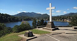
In 1922, a large, lighted cross was erected at a spot overlooking the lake near Lambuth Inn, the oldest hotel at the lake. In 1994, a new cross was installed. The original, eventually restored, was moved to Mount Shepherd Retreat Center near Asheboro, North Carolina. [8]

The Southeastern Jurisdiction (SEJ) of the United Methodist Church became the owner in 1948. [6] Lake Junaluska Assembly Inc., an agency of the SEJ, has been tax-exempt since 1959. [9] In the 1950s, the World Methodist Council, [6] a consultative body linking almost all Methodist denominations worldwide,[ citation needed ] moved its headquarters to Lake Junaluska. [6] In Spring 2021, the World Methodist Council sold its headquarters building, including a museum, to the assembly for $1.25 million. The World Methodist Council moved to offices in nearby Waynesville. The museum's collection moved to Southern Methodist University. [10]

Conference and Retreat Center

Lake Junaluska Assembly Inc. received financial support from the United Methodist Church for nearly 100 years, but that support ended and the Assembly became more of a business. [11] The Lake Junaluska Assembly Board of Directors, in addition to acting as the "de facto government", owns the Lake Junaluska Conference and Retreat Center, the lake and the dam, and recreational facilities. The board voted in March 2013 to ask for Waynesville to annex the community. [12]

The Lake Junaluska Conference and Retreat Center hosts events for the United Methodist Church, Seventh-day Adventist Church, The Salvation Army, Church of the Brethren, and other organizations. Several musical events are hosted in Stuart Auditorium, including Folkmoot USA programs and Appalachian bluegrass concerts. The Smoky Mountain Folk Festival is held here. The facilities are intended to be used for the renewal of "body, mind and spirit".

The Terrace Hotel and the Lambuth Inn, the community's primary accommodations, were extensively renovated in 2015 and 2018. [13] The Corneille Bryan Native Garden contains many plants once abundant in the region but now rare. [14]

Memorial Chapel Memorial Chapel, Lake Junaluska, NC.jpg
Memorial Chapel

The Conference and Retreat Center is governed by an active, diverse 32-member Board of Trustees. Some 68% of the Board members are property owners in the Lake Junaluska community. The board provides strategic direction, and budget approval for the Conference and Retreat Center, the Lake Junaluska Public Works, residential fees, and utility (water and sewer) rates. The Executive Director, who has day-to-day management responsibility, reports to the board of Trustees. The board approves changes to the rules and regulations of the community. [15]

The amenities of Lake Junaluska include lodging, meeting facilities, dining (food service), trails, gardens, meditation areas, golf, and other recreation opportunities. The maintenance of the public areas around the lake and the dam, which is inspected annually, are funded primarily through charitable giving and proceeds from lodging guests. There is periodic removal of sediment that has been carried into the lake from Richland Creek. All property within the boundaries of the Assembly, approximately 5.8 square miles (15 km2), has deed covenant restrictions that give the Board of Trustees the right to enforce regulations and the first right of refusal on all property sales. [16]

Work began in 2022 on a $2.5 million renovation of the former World Methodist Council headquarters, which Lake Junaluska purchased for $1.25 million along with an adjacent building in 2021. The former headquarters was named the Warren Center for Mike and Anne Warren, who gave $625,000 toward the purchase and $1.1 million for the renovation. The building will be used for smaller events. [17]

Geography

Lake Junaluska dam 15 19 0262 junaluska dam.jpg
Lake Junaluska dam

The community of Lake Junaluska is located in central Haywood County just east of the artificial lake of the same name. The lake was formed by damming Richland Creek (a tributary to the Pigeon River) which flows northwest of the community. [18] Haywood County has 18 mountain peaks over 6,000 feet (1,800 m), more than any other county east of the Mississippi River. The closest high summits are 4,228-foot (1,289 m) High Top on Utah Mountain, 2 miles (3 km) to the north; and 5,071-foot (1,546 m) North Eaglenest Mountain (formerly Mount Junaluska), 4 miles (6 km) to the southwest.

North Eaglenest Mountain, formerly called Mount Junaluska Lake Junaluska, North Carolina.jpg
North Eaglenest Mountain, formerly called Mount Junaluska

The community is bordered by Waynesville, the Haywood county seat, to the south; Maggie Valley to the west, and Clyde to the east. U.S. Routes 19, 23, 74, and 276 all pass through the community. Interstate 40 passes just northeast of the community, with access from Exits 24 and 27.

Asheville, the major city in the region, is 27 miles (43 km) to the east via I-40 or by Routes 19, 23, and 74. Route 19 leads west 25 miles (40 km) to Cherokee, base on the Eastern Band of Cherokee Indians and near the south entrance to Great Smoky Mountains National Park. Routes 23 and 74, the Great Smoky Mountains Expressway, leads southwest 22 miles (35 km) to Sylva, and US 276 leads southeast through Waynesville and 41 miles (66 km) to Brevard.

According to the U.S. Census Bureau, the Lake Junaluska CDP has a total area of 5.6 square miles (14.6 km2), of which 5.3 square miles (13.8 km2) are land and 0.3 square miles (0.8 km2), or 5.53%, are water. [4]

Climate

Lake Junaluska has an oceanic climate under the Köppen climate classification (Köppen Cfb). Monthly temperature averages range from 37.2 °F (2.9 °C) in January to 70.9 °F (21.6 °C) in July. Precipitation averages 46.1 inches (1,170 mm) annually, and snowfall averages 13.8 inches (350 mm). [19]

Climate data for Lake Junaluska, North Carolina
MonthJanFebMarAprMayJunJulAugSepOctNovDecYear
Record high °F (°C)78
(26)
79
(26)
89
(32)
89
(32)
92
(33)
98
(37)
98
(37)
96
(36)
92
(33)
90
(32)
83
(28)
78
(26)
98
(37)
Mean daily maximum °F (°C)49.0
(9.4)
52.3
(11.3)
59.5
(15.3)
67.7
(19.8)
74.9
(23.8)
80.9
(27.2)
83.4
(28.6)
82.7
(28.2)
77.0
(25.0)
69.0
(20.6)
60.1
(15.6)
51.1
(10.6)
67.3
(19.6)
Mean daily minimum °F (°C)23.3
(−4.8)
26.1
(−3.3)
32.0
(0.0)
38.9
(3.8)
47.2
(8.4)
55.3
(12.9)
59.1
(15.1)
58.6
(14.8)
51.6
(10.9)
40.4
(4.7)
31.7
(−0.2)
25.5
(−3.6)
40.8
(4.9)
Record low °F (°C)−22
(−30)
−16
(−27)
−8
(−22)
15
(−9)
24
(−4)
31
(−1)
40
(4)
38
(3)
27
(−3)
12
(−11)
0
(−18)
−8
(−22)
−22
(−30)
Average precipitation inches (mm)4.33
(110)
4.48
(114)
4.39
(112)
3.76
(96)
4.30
(109)
4.07
(103)
3.71
(94)
4.20
(107)
3.94
(100)
2.65
(67)
3.73
(95)
4.04
(103)
47.61
(1,209)
Average snowfall inches (cm)4.7
(12)
3.0
(7.6)
2.5
(6.4)
1.2
(3.0)
0.2
(0.51)
0
(0)
0
(0)
0
(0)
0
(0)
0
(0)
0.4
(1.0)
2.0
(5.1)
14.1
(36)
Average precipitation days (≥ 0.01 in)10.710.711.711.512.613.014.112.610.18.410.111.0136.5
Average snowy days (≥ 0.1 in)2.12.11.20.30000000.41.47.6
Source: NOAA (normals 1981−2010) [20]

Today

Malcom the Swan 15 18 285 malcom swan.jpg
Malcom the Swan

The Lake Junaluska Public Works office manages the roads and utilities. Water for the community is purchased from the town of Waynesville, and sewage treatment is provided by Waynesville through a purchase agreement. Water and sewer fees and annual service fees provide funds for maintenance and improvements to the infrastructure. The community has engaged in a program to renew roads and systematically replace water and sewer lines without incurring debt. A prioritized list of improvements was initially developed, [21] and replacement of the oldest underground water lines has saved money by reducing water loss due to leakage.

A Community Council of elected representatives provides guidance to the public works office and Conference and Retreat Center leadership on issues that impact the community, such as utility rates, annual service charges, residential rules, and regulations. [22] [23] Open monthly meetings also provide a means for the property owners to learn about new developments in the community and provide input to the council and the conference and retreat center leadership.

The community of residents, year-round and seasonal alike, are a very diverse active group that enjoy many opportunities for involvement in recreation and fellowship. Community organizations include the Lake Junaluska Assembly Property Owners organization (LJAPOO), [24] which addresses issues associated with the ownership, and the Junaluskans, which is a service group that meets twice monthly and supports many activities.

The campus is also the home to the Foundation for Evangelism, [25] a non-profit organization serving ministries of the United Methodist Church by promoting the growth of new generations of clergy and laity that have a passion for evangelism.

Demographics

Historical population
CensusPop.Note
2020 3,219
U.S. Decennial Census [26]

2020 census

Lake Junaluska racial composition [27]
RaceNumberPercentage
White (non-Hispanic)2,96492.08%
Black or African American (non-Hispanic)190.59%
Native American 110.34%
Asian 270.84%
Other/Mixed 772.39%
Hispanic or Latino 1213.76%

As of the 2020 United States census, there were 3,219 people, 1,477 households, and 841 families residing in the CDP.

2000 census

As of the census [3] of 2000, there were 2,675 people, 1,262 households, and 861 families residing in the CDP. The population density was 483.6 inhabitants per square mile (186.7/km2). There were 1,848 housing units at an average density of 334.1 per square mile (129.0/km2). The racial makeup of the CDP was 98.65% White, 0.37% African American, 0.26% Native American, 0.11% Asian, 0.07% from other races, and 0.52% from two or more races. Hispanic or Latino of any race were 1.35% of the population.

There were 1,262 households, out of which 18.1% had children under the age of 18 living with them, 58.3% were married couples living together, 7.8% had a female householder with no husband present, and 31.7% were non-families. 29.5% of all households were made up of individuals, and 14.3% had someone living alone who was 65 years of age or older. The average household size was 2.12 and the average family size was 2.57.

In the CDP, the population was spread out, with 16.2% under the age of 18, 5.7% from 18 to 24, 20.6% from 25 to 44, 29.4% from 45 to 64, and 28.1% who were 65 years of age or older. The median age was 50 years. For every 100 females, there were 86.7 males. For every 100 females age 18 and over, there were 82.1 males.

The median income for a household in the CDP was $46,932, and the median income for a family was $54,444. Males had a median income of $38,224 versus $29,219 for females. The per capita income for the CDP was $23,031. About 4.2% of families and 8.7% of the population were below the poverty line, including 17.9% of those under age 18 and 3.0% of those age 65 or over.

Related Research Articles

<span class="mw-page-title-main">Swain County, North Carolina</span> County in North Carolina, United States

Swain County is a county located on the far western border of the U.S. state of North Carolina. As of the 2020 census, the population was 14,117. Its county seat is Bryson City.

<span class="mw-page-title-main">Jackson County, North Carolina</span> County in North Carolina, United States

Jackson County is a county located in the western part of the U.S. state of North Carolina. As of the 2020 census, the population was 43,109. Since 1913, its county seat has been Sylva, which replaced Webster.

<span class="mw-page-title-main">Haywood County, North Carolina</span> County in North Carolina, United States

Haywood County is a county located in the U.S. state of North Carolina. As of the 2020 census, the population was 62,089. The county seat and its largest community is Waynesville.

<span class="mw-page-title-main">Cherokee County, North Carolina</span> County in North Carolina, United States

Cherokee County is the westernmost county in the U.S. state of North Carolina. It borders Tennessee to its west and Georgia to its south. As of the 2020 census, the population was 28,774. The county seat is Murphy.

<span class="mw-page-title-main">Canton, North Carolina</span> Town in North Carolina, United States

Canton is the second largest town in Haywood County, North Carolina, United States. It is located about 17 miles (27 km) west of Asheville and is part of that city's metropolitan area. The town is named after the city of Canton, Ohio. The population was 4,422 at the 2020 census.

<span class="mw-page-title-main">Clyde, North Carolina</span> Town in North Carolina, United States

Clyde is a town in Haywood County, North Carolina, United States. The 2010 census recorded the population at 1,223 people. It is part of the Asheville Metropolitan Statistical Area.

<span class="mw-page-title-main">Waynesville, North Carolina</span> Town in North Carolina, United States

Waynesville is the county seat of Haywood County, North Carolina. It is the largest town in North Carolina west of Asheville. Waynesville is located about 30 miles (50 km) southwest of Asheville between the Great Smoky and Blue Ridge Mountains.

<span class="mw-page-title-main">West Canton, North Carolina</span> Census-designated place in North Carolina, United States

West Canton is an unincorporated community and census-designated place (CDP) in Haywood County, North Carolina, United States. The population was 1,247 at the 2010 census. It is part of the Asheville Metropolitan Statistical Area.

<span class="mw-page-title-main">U.S. Route 276</span> Highway in the United States

U.S. Route 276 is a United States highway that runs for 106.4 miles (171.2 km) from Mauldin, South Carolina to Cove Creek, North Carolina. It is known both as a busy urban highway in Greenville, South Carolina and a scenic back-road in Western North Carolina. Despite its numbering, it does not intersect its parent route U.S. Route 76.

<span class="mw-page-title-main">Tuscola High School</span> School in Waynesville, North Carolina, United States

Tuscola High School is a public senior high school located in Waynesville, North Carolina, United States, about 30 miles west-southwest of Asheville. Tuscola High School succeeded the original Waynesville Township High School during the 1966 consolidation that merged Fines Creek and Crabtree High Schools with Waynesville. The school was built in the Tuscola community of East Waynesville, near Lake Junaluska and was named after the community in which it was built. Tuscola is a Cherokee word that means "Digging in Many Places". The school's mascot is a Mountaineer and the school colors are black and gold.

<span class="mw-page-title-main">Harrah's Cherokee Center</span> Entertainment center in North Carolina, United States

The Harrah's Cherokee Center – Asheville, previously known as the U.S. Cellular Center and originally as the Asheville Civic Center Complex, is a multipurpose entertainment center, located in Asheville, North Carolina. Opened in 1974, the complex is home to an arena, auditorium, banquet hall and meeting rooms.

<span class="mw-page-title-main">World Methodist Council</span> Consultative body and association of churches in the Methodist tradition, founded in 1881

The World Methodist Council (WMC), founded in 1881, is a consultative body and association of churches in the Methodist tradition. It comprises 80 member denominations in 138 countries which together represent an estimated 80 million people; this includes approximately 60 million committed members and a further 20 million adherents. But there is also another, contradictory, number of members of the member churches on the WMC's website: about 40 million. It is the fifth-largest Christian communion after the Roman Catholic Church, Eastern Orthodox Church, Anglican Communion, and World Communion of Reformed Churches.

<span class="mw-page-title-main">Western North Carolina</span> Geographic region of the U.S. state of North Carolina

Western North Carolina is the region of North Carolina which includes the Appalachian Mountains; it is often known geographically as the state's Mountain Region. It contains the highest mountains in the Eastern United States, with 125 peaks rising to over 5,000 feet in elevation. Mount Mitchell at 6,684 feet, is the highest peak of the Appalachian Mountains and mainland eastern North America. The population of the 23 most commonly associated counties for the region, as measured by the 2020 U.S. Census, is 1,149,405. The region accounts for approximately 11% of North Carolina's total population.

The Great Smoky Mountains Expressway is a four-lane divided highway that serves as the main east–west corridor through Southwestern North Carolina; connecting the towns of Bryson City, Sylva and Waynesville to Interstate 40. Its establishment and funding was made possible by the Appalachian Development Highway System (ADHS), designed to generate economic development in previously isolated areas, supplement the interstate system and provide access to areas within the region as well as to markets in the rest of the nation.

<span class="mw-page-title-main">Asheville metropolitan area</span> Metropolitan area in North Carolina, United States

The Asheville metropolitan area is a metropolitan area centered on the principal city of Asheville, North Carolina. The U.S. Office of Management and Budget defines the Asheville, NC Metropolitan Statistical Area, a metropolitan statistical area used by the United States Census Bureau and other entities, as comprising the four counties of Buncombe, Haywood, Henderson, and Madison. The area's population was 424,858 according to the 2010 census, and 469,454 according to the 2020 census.

<span class="mw-page-title-main">U.S. Route 19 in North Carolina</span> Segment of American highway

U.S. Highway 19 (US 19) traverses 145 miles (233 km) across Western North Carolina; from the Georgia state line, at the community of Bellview, to Cane River, where US 19 splits into US 19E and US 19W, which take separate routes into Tennessee.

Eaglenest Mountain is a mountain located 2 miles south of Maggie Valley, North Carolina in Haywood County. It is part of the Plott Balsams, a range of the Appalachian Mountains, and less than a mile south of North Eaglenest Mountain, a higher mountain which used to be called Mount Junaluska and is the highest mountain overlooking Lake Junaluska from the southwest. The closest town that is accessible by road is Hazelwood. Hazelwood was absorbed into the larger incorporated Town of Waynesville in 1995.

<span class="mw-page-title-main">North Eaglenest Mountain</span>

North Eaglenest Mountain is a mountain located less than 2 miles (3.2 km) south of Maggie Valley, North Carolina, US, in Haywood County. It is part of the Plott Balsams, a range of the Appalachian Mountains, and less than a mile north of Eaglenest Mountain. It used to be called Mount Junaluska and is the highest mountain overlooking Lake Junaluska from the west.

Folkmoot USA, The State International Festival of North Carolina, is an international folk festival held since 1984 in Waynesville, North Carolina and surrounding communities. During its history, the two-week event has featured around 8000 performers from approximately 200 countries. The Folkmoot USA non-profit organization has its headquarters in the former Hazelwood Elementary School. The name "Folkmoot", used for a festival in Newcastle upon Tyne, England, means "meeting of the people". The North Carolina General Assembly declared Folkmoot USA to be the state's official international folk festival in 2003. The Southeast Tourism Society has named Folkmoot USA one of its top twenty events for 20 years.

<span class="mw-page-title-main">Lambuth Inn</span> United States historic place

Lambuth Inn, also known as Mission Centenary Inn and the Lambeth Hotel, is a historic hotel building located at Lake Junaluska, Haywood County, North Carolina. It was built in 1921, and is a large Classic Revival style building consisting of a long rectangular block with three short rear wings. It is flanked by buff-colored brick additions extending symmetrically from each end, one made in 1956 and one in 1964. It features a massive pedimented portico with six three-story Ionic order columns. It was the main hotel facility of the United Methodist Church's Lake Junaluska Assembly. Renovation was done in 1983-1984 and 2018.

References

  1. 1 2 3 U.S. Geological Survey Geographic Names Information System: Lake Junaluska, North Carolina
  2. "ArcGIS REST Services Directory". United States Census Bureau. Retrieved September 20, 2022.
  3. 1 2 "U.S. Census website". United States Census Bureau . Retrieved 2008-01-31.
  4. 1 2 "Geographic Identifiers: 2010 Census Summary File 1 (G001): Lake Junaluska CDP, North Carolina". American Factfinder. U.S. Census Bureau. Archived from the original on February 13, 2020. Retrieved December 15, 2017.
  5. 1 2 Shearer, John (2013-06-29). "100 years of soul renewal". Asheville Citizen-Times . p. B4 via newspapers.com.
  6. 1 2 3 4 Caldwell, Neill. "A Brief History of Lake Junaluska". Archived from the original on 2012-02-11. Retrieved 2023-08-05.
  7. "National Register Information System". National Register of Historic Places . National Park Service. July 9, 2010.
  8. "The Junaluska Cross". Archived from the original on 2008-05-15. Retrieved 2008-06-17., Retrieved on 2008/06/17.
  9. "Lake Junaluska Assembly Inc". Charity Navigator . Retrieved 2021-06-20.
  10. Hyatt, Vicki (16 June 2021). "Benefactors discuss significance of World Methodist Council building". The Mountaineer . Retrieved 18 June 2021.
  11. Vaillancourt, Cory (2017-11-08). "Transformation continues at Lake Junaluska". Smoky Mountain News . Retrieved 2021-06-20.
  12. "Here's to 100 more years for Lake Junaluska". Asheville Citizen-Times. 2013-07-08. p. A7 via newspapers.com.
  13. Report of the Lake Junaluska Assembly Inc to the Southeastern Jurisdiction of the United Methodist Church 2018
  14. "Natural Haven". ourstate.com. Retrieved 2023-08-05.
  15. Report of the Lake Junaluska Assembly Inc to the Southeastern Jurisdiction of the United Methodist Church 2015
  16. "APW Services | Lake Junaluska Assembly Public Works".
  17. Johnson, Becky (22 December 2022). "Making the grade: Lake Junaluska continues multi-million dollar upgrades with new event venue". The Mountaineer.
  18. Clyde, NC, 7.5 Minute Topographic Quadrangle, USGS, 1967 (1979 rev.)
  19. "Lake Junaluska, North Carolina Travel Weather Averages (Weatherbase)".
  20. "NOWData - NOAA Online Weather Data". National Oceanic and Atmospheric Administration . Retrieved December 1, 2012.
  21. "Homepage" (PDF).
  22. "Junaluska Assembly Community Council | Lake Junaluska Assembly Public Works".
  23. "Homepage" (PDF).
  24. "Lake Junaluska Assembly Property Owners Organization, Inc".
  25. "Foundation for Evangelism - To promote, encourage and provide resources for Wesleyan evangelism" . Retrieved 2023-08-05.
  26. "Census of Population and Housing". Census.gov. Retrieved June 4, 2016.
  27. "Explore Census Data". data.census.gov. Retrieved 2021-12-19.

Further reading