
Transylvania County is a county in the U.S. state of North Carolina. As of the 2020 census the population is 32,986. Its county seat is Brevard.

Madison County is a county located in the U.S. state of North Carolina. As of the 2020 census, the population was 21,193. Its county seat is Marshall. Madison County is part of the Asheville, NC Metropolitan Statistical Area.

Henderson County is a county located in the U.S. state of North Carolina. As of the 2020 census, the population was 116,281. Its county seat is Hendersonville.

Haywood County is a county located in the U.S. state of North Carolina. As of the 2020 census, the population was 62,089. The county seat and its largest community is Waynesville.
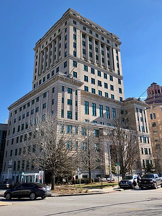
Buncombe County is a county located in the U.S. state of North Carolina. It is classified within Western North Carolina. The 2020 census reported the population was 269,452, making it the 7th-most populous county in North Carolina. Its county seat is Asheville. Buncombe County is part of the Asheville, NC Metropolitan Statistical Area.
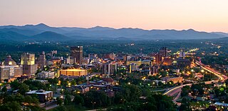
Asheville is a city in and the county seat of Buncombe County, North Carolina, United States. Located at the confluence of the French Broad and Swannanoa rivers, it is the most populous city in Western North Carolina, and the state's 11th-most-populous city. According to the 2020 census, the city's population was 94,589, up from 83,393 in the 2010 census. It is the principal city in the three-county Asheville metropolitan area, which had an estimated population of 417,202 in 2023.

Avery Creek is a census-designated place (CDP) in Buncombe County, North Carolina, United States. The population was 1,950 at the 2010 census. It is part of the Asheville Metropolitan Statistical Area.

Clyde is a town in Haywood County, North Carolina, United States. The 2010 census recorded the population at 1,223 people. It is part of the Asheville Metropolitan Statistical Area.

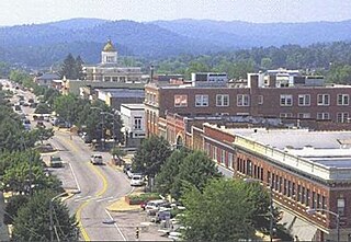
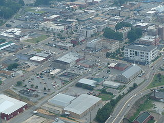
Waynesville is the county seat of Haywood County, North Carolina, United States. It is the largest town in North Carolina west of Asheville. Waynesville is located about 30 miles (50 km) southwest of Asheville between the Great Smoky and Blue Ridge Mountains.

West Canton is an unincorporated community and census-designated place (CDP) in Haywood County, North Carolina, United States. The population was 1,247 at the 2010 census. It is part of the Asheville Metropolitan Statistical Area.

Fletcher is a town in Henderson County, North Carolina, United States. The population was 7,187 at the 2010 census, and was estimated to be 8,333 in 2018.
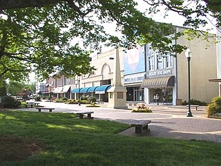
Hendersonville is a city in and the county seat of Henderson County, North Carolina, United States, located 22 miles (35 km) south of Asheville. Like the county, the city is named for 19th-century North Carolina Supreme Court Chief Justice Leonard Henderson.

Western North Carolina is the region of North Carolina which includes the Appalachian Mountains; it is often known geographically as the state's Mountain Region. It contains the highest mountains in the Eastern United States, with 125 peaks rising to over 5,000 feet in elevation. Mount Mitchell at 6,684 feet, is the highest peak of the Appalachian Mountains and mainland eastern North America. The population of the 23 most commonly associated counties for the region, as measured by the 2020 U.S. Census, is 1,149,405. The region accounts for approximately 11% of North Carolina's total population.
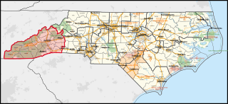
North Carolina's 11th congressional district encompasses most of Western North Carolina. Since January 3, 2023, the district has been represented by Chuck Edwards.
The Jackson, Tennessee Metropolitan Statistical Area, as defined by the United States Census Bureau, is an area consisting of four counties - Madison, Chester, Gibson, Crockett - in western Tennessee, anchored by the city of Jackson. As of the 2020 census, the MSA had a population of 180,509.
The Hickory–Lenoir–Morganton, NC Metropolitan Statistical Area, as defined by the United States Census Bureau, is an area consisting of four counties, Catawba, Burke, Caldwell, Alexander. It is located in the Catawba Valley region of western North Carolina. Local residents often refer to the area as The Unifour, although this name is largely unknown outside of the region.

The Fayetteville, NC Metropolitan Statistical Area, as defined by the US Office of Management and Budget (OMB), is an area consisting of three counties – Cumberland, Harnett, and Hoke – in eastern North Carolina, anchored by the city of Fayetteville. It is served by Interstate 95, Interstate 295, U.S. and state highways, Fayetteville Regional Airport, Amtrak, Greyhound, Megabus and several railroad systems. As of the 2000 census, the MSA had a population of 336,609. As of the 2010 census the MSA had a population of 366,383. In 2011 the estimated population was 374,157. The 2019 estimated population is 526,719.

North Carolina Highway 280 (NC 280) is a primary state highway in the U.S. state of North Carolina that runs from the city of Brevard in Transylvania County to the town of Fletcher in Henderson County. It is 18 miles (29 km) in length, starting at the intersection with US 64 and US 276 north of Brevard to US 25 and US 25A in the Asheville community of Arden.

The Canton–Massillon Metropolitan Statistical Area, as defined by the United States Census Bureau, is an area consisting of two counties in Northeast Ohio, anchored by the cities of Canton and Massillon. As of the 2020 census, the MSA had a population of 401,574. The MSA is also part of the Cleveland–Akron–Canton, OH Combined Statistical Area, which had a population of 3,633,962 in 2020, making it the largest CSA in Ohio.
North Carolina Highway 191 (NC 191) is a primary state highway in the U.S. state of North Carolina. It travels within portions of Henderson and Buncombe Counties.
