Wilson County, North Carolina

Last updated

Wilson County
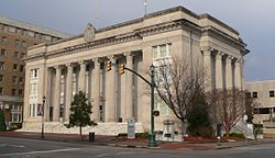
Wilson County NC courthouse from SSW 1.JPG
Wilson County Seal.jpg
Wilson County Logo.png
Map of North Carolina highlighting Wilson County.svg
Location within the U.S. state of North Carolina
North Carolina in United States.svg
North Carolina's location within the U.S.
Coordinates: 35°42′N77°55′W / 35.70°N 77.92°W / 35.70; -77.92
CountryFlag of the United States.svg United States
StateFlag of North Carolina.svg  North Carolina
Founded1855
Named for Col. Louis D. Wilson
Seat Wilson
Largest communityWilson
Area
  Total373.10 sq mi (966.3 km2)
  Land367.57 sq mi (952.0 km2)
  Water5.53 sq mi (14.3 km2)  1.48%
Population
 (2020)
  Total78,784
  Estimate 
(2023)
78,970
  Density214.34/sq mi (82.76/km2)
Time zone UTC−5 (Eastern)
  Summer (DST) UTC−4 (EDT)
ZIP Codes
27542, 27557, 27803, 27807, 27813, 27822, 27829, 27830, 27851, 27852, 27873, 27878, 27880, 27883, 27888, 27893, 27895, 27896
Area code 252
Congressional district 1st
Website www.wilsoncountync.gov

Wilson County is a county located in the U.S. state of North Carolina. As of the 2020 census, the population was 78,784. [1] The county seat is Wilson. [2] The county comprises the Wilson, NC Micropolitan Statistical Area, which is also included within the Rocky Mount-Wilson-Roanoke Rapids, NC Combined Statistical Area.

Contents

History

On February 13, 1855, the North Carolina General Assembly established Wilson County from parts of Edgecombe, Johnston, Nash, and Wayne counties. [3] The county was named for Colonel Louis D. Wilson, a U.S. Volunteers soldier, who died of yellow fever while on leave from the state senate during the Mexican–American War. [4]

Wilson Speedway held 12 NASCAR Cup Series races at the county fairgrounds in Wilson between 1951 and 1960. The half mile dirt track operated between 1934 and 1989.

Geography

Wilson County, North Carolina
Interactive map of Wilson County

According to the U.S. Census Bureau, the county has a total area of 373.10 square miles (966.3 km2), of which 367.57 square miles (952.0 km2) is land and 5.53 square miles (14.3 km2) (1.48%) is water. [5]

State and local protected site

Major water bodies

Adjacent counties

Major highways

Major infrastructure

Demographics

Historical population
CensusPop.Note
1860 9,720
1870 12,25826.1%
1880 16,06431.0%
1890 18,64416.1%
1900 23,59626.6%
1910 28,26919.8%
1920 36,81330.2%
1930 44,91422.0%
1940 50,21911.8%
1950 54,5068.5%
1960 57,7165.9%
1970 57,486−0.4%
1980 63,1329.8%
1990 66,0614.6%
2000 73,81411.7%
2010 81,23410.1%
2020 78,784−3.0%
2023 (est.)78,970 [1] 0.2%
U.S. Decennial Census [11]
1790–1960 [12] 1900–1990 [13]
1990–2000 [14] 2010 [15] 2020 [1]

2020 census

Wilson County racial composition [16]
RaceNumberPercentage
White (non-Hispanic)36,10645.83%
Black or African American (non-Hispanic)29,84237.88%
Native American 2390.3%
Asian 9001.14%
Pacific Islander 100.01%
Other/Mixed 2,6633.38%
Hispanic or Latino 9,02411.45%

As of the 2020 census, there were 78,784 people, 32,384 households, and 19,760 families residing in the county. The population density was 199 people per square mile (77 people/km2). There were 30,729 housing units at an average density of 83 units per square mile (32 units/km2). There were 28,613 households, out of which 31.90% had children under the age of 18 living with them, 48.10% were married couples living together, 16.50% had a female householder with no husband present, and 30.90% were non-families. 26.40% of all households were made up of individuals, and 10.20% had someone living alone who was 65 years of age or older. The average household size was 2.51 and the average family size was 3.03.

In the county, the population was spread out, with 25.60% under the age of 18, 9.10% from 18 to 24, 28.80% from 25 to 44, 23.60% from 45 to 64, and 12.90% who were 65 years of age or older. The median age was 36 years. For every 100 females there were 91.30 males. For every 100 females age 18 and over, there were 87.20 males.

The median income for a household in the county was $33,116, and the median income for a family was $41,551. Males had a median income of $30,364 versus $21,997 for females. The per capita income for the county was $17,102. About 13.80% of families and 18.50% of the population were below the poverty line, including 24.70% of those under age 18 and 21.30% of those age 65 or over.
Government and politics

Wilson County government is a member of the regional Upper Coastal Plain Council of Governments. It has several law-enforcement agencies:

United States presidential election results for Wilson County, North Carolina [17]
Year Republican Democratic Third party
No.%No.%No.%
2020 19,58148.07%20,75450.95%4000.98%
2016 17,53145.97%19,66351.56%9412.47%
2012 17,95445.91%20,87553.38%2800.72%
2008 17,37546.72%19,65252.84%1640.44%
2004 16,26453.26%14,20646.52%650.21%
2000 13,46654.24%11,26645.38%940.38%
1996 10,51849.03%9,77945.59%1,1545.38%
1992 10,17644.36%10,10544.06%2,65611.58%
1988 10,99757.11%8,21442.65%460.24%
1984 12,24359.31%8,34340.42%570.28%
1980 8,32949.86%8,04248.14%3331.99%
1976 6,79545.05%8,20954.42%800.53%
1972 12,06073.04%4,16625.23%2861.73%
1968 4,05325.13%4,17325.87%7,90349.00%
1964 5,00240.87%7,23859.13%00.00%
1960 3,11427.97%8,02172.03%00.00%
1956 2,83025.36%8,32874.64%00.00%
1952 2,56922.83%8,68477.17%00.00%
1948 6659.55%6,00886.25%2934.21%
1944 76910.61%6,48089.39%00.00%
1940 5846.87%7,91293.13%00.00%
1936 5496.80%7,52293.20%00.00%
1932 5177.69%6,15391.55%510.76%
1928 1,93335.35%3,53564.65%00.00%
1924 57417.53%2,61979.99%812.47%
1920 1,37428.21%3,49671.79%00.00%
1916 73026.24%2,05273.76%00.00%
1912 823.44%1,74173.03%56123.53%

Communities

Map of Wilson County with municipal and township labels Map of Wilson County North Carolina With Municipal and Township Labels.PNG
Map of Wilson County with municipal and township labels

City

Towns

Townships

  • Black Creek
  • Cross Roads
  • Gardners
  • Old Fields
  • Saratoga
  • Springhill
  • Stantonsburg
  • Taylors
  • Toisnot
  • Wilson

Unincorporated communities

See also

Related Research Articles

<span class="mw-page-title-main">Wayne County, North Carolina</span> County in North Carolina, United States

Wayne County is a county located in the U.S. state of North Carolina. As of the 2020 census, the population was 117,333. Its county seat is Goldsboro and it is home to Seymour Johnson Air Force Base.

<span class="mw-page-title-main">Warren County, North Carolina</span> County in North Carolina, United States

Warren County is a county located in the northeastern Piedmont region of the U.S. state of North Carolina, on the northern border with Virginia, made famous for a landfill and birthplace of the environmental justice movement. As of the 2020 census, its population was 18,642. Its county seat is Warrenton. It was a center of tobacco and cotton plantations, education, and later textile mills.

<span class="mw-page-title-main">Pitt County, North Carolina</span> County in North Carolina, United States

Pitt County is a county located in the Inner Banks region of the U.S. state of North Carolina. As of the 2020 census, the population was 170,243, making it the 14th-most populous county in North Carolina. Its county seat is Greenville.

<span class="mw-page-title-main">Pender County, North Carolina</span> County in North Carolina, United States

Pender County is a county located in the U.S. state of North Carolina. As of the 2020 census, the population was 60,203. Its county seat is Burgaw. Pender County is part of the Wilmington, NC Metropolitan Statistical Area.

<span class="mw-page-title-main">Nash County, North Carolina</span> County in North Carolina, United States

Nash County is a county located in the U.S. state of North Carolina. As of the 2020 census, the population was 94,970. Its county seat is Nashville.

<span class="mw-page-title-main">Martin County, North Carolina</span> County in North Carolina, United States

Martin County is a county located in the U.S. state of North Carolina. As of the 2020 census, the population was 22,031. Its county seat is Williamston.

<span class="mw-page-title-main">Madison County, North Carolina</span> County in North Carolina, United States

Madison County is a county located in the U.S. state of North Carolina. As of the 2020 census, the population was 21,193. Its county seat is Marshall. Madison County is part of the Asheville, NC Metropolitan Statistical Area.

<span class="mw-page-title-main">Lee County, North Carolina</span> County in North Carolina, United States

Lee County is a county located in the U.S. state of North Carolina. As of the 2020 census, the population was 63,285. The county seat is Sanford.

<span class="mw-page-title-main">Johnston County, North Carolina</span> County in North Carolina, United States

Johnston County is a county located in the U.S. state of North Carolina. As of the 2020 census, the population was 215,999. Its county seat is Smithfield.

<span class="mw-page-title-main">Halifax County, North Carolina</span> County in North Carolina, United States

Halifax County is a county located in the U.S. state of North Carolina. As of the 2020 census, the population was 48,622. Its county seat is Halifax.

<span class="mw-page-title-main">Granville County, North Carolina</span> County in North Carolina, United States

Granville County is a county located on the northern border of the U.S. state of North Carolina. As of the 2020 census, the population was 60,992. Its county seat is Oxford. The county has access to Kerr Lake and Falls Lake and is part of the Roanoke, Tar and Neuse River watersheds.

<span class="mw-page-title-main">Franklin County, North Carolina</span> County in North Carolina, United States

Franklin County is a county located in the U.S. state of North Carolina. As of the 2020 census, the population was 68,573. Its county seat is Louisburg.

<span class="mw-page-title-main">Edgecombe County, North Carolina</span> County in North Carolina, United States

Edgecombe County is a county located in the U.S. state of North Carolina. As of the 2020 census, the population was 48,900. Its county seat is Tarboro.

<span class="mw-page-title-main">Duplin County, North Carolina</span> County in North Carolina, United States

Duplin County is a county located in the U.S. state of North Carolina. As of the 2020 census, the population was 48,715. Its county seat is Kenansville.

<span class="mw-page-title-main">Bertie County, North Carolina</span> County in North Carolina, United States

Bertie County is a county located in the northeast area of the U.S. state of North Carolina. As of the 2020 census, the population was 17,934. Its county seat is Windsor. The county was created in 1722 as Bertie Precinct and gained county status in 1739.

<span class="mw-page-title-main">Stantonsburg, North Carolina</span> Town in North Carolina, United States

Stantonsburg is a town in Wilson County, North Carolina, United States. It is named for James Stanton V. The population was 784 at the 2010 census.

<span class="mw-page-title-main">Wilson, North Carolina</span> City in North Carolina, United States

Wilson is a city in and the county seat of Wilson County, North Carolina, United States. It is the 23rd most populous city in North Carolina. Located approximately 40 mi (64 km) east of the capital city of Raleigh, it is served by the interchange of Interstate 95 and U.S. Route 264. Wilson had an estimated population of 49,459 in 2019, according to the U.S. Census Bureau, and is also an anchor city of the Rocky Mount-Wilson-Roanoke Rapids CSA, with a total population of 297,726 as of 2018.

<span class="mw-page-title-main">Sharpsburg, North Carolina</span> Town in North Carolina, United States

Sharpsburg is a town in Edgecombe, Nash, and Wilson counties, North Carolina, United States. It is part of the Rocky Mount, North Carolina Metropolitan Statistical Area. The population was 2,024 at the 2010 Census.

<span class="mw-page-title-main">Rocky Mount metropolitan area</span> MSA in North Carolina, United States

The Rocky Mount, NC Metropolitan Statistical Area, as defined by the United States Census Bureau, is an area consisting of two counties – Edgecombe and Nash – in eastern North Carolina, anchored by the city of Rocky Mount. As of the 2010 census, the MSA had a population of 152,392. It is commonly referred to as the Twin Counties.

<span class="mw-page-title-main">Rocky Mount-Wilson-Roanoke Rapids combined statistical area</span> CSA in North Carolina, United States

The Rocky Mount-Wilson-Roanoke Rapids Combined Statistical Area, as defined by the United States Census Bureau, is an area consisting of five counties in northeastern North Carolina. As of the 2010 census, the CSA had a population of 310,416, with an estimated population of 297,726 in 2018. The statistical area includes the Rocky Mount Metropolitan Statistical Area, Wilson Micropolitan Statistical Area, and Roanoke Rapids Micropolitan Statistical Area, and the counties of Nash, Wilson, Edgecombe, Halifax, Northampton.

References

  1. 1 2 3 "QuickFacts: Wilson County, North Carolina". United States Census Bureau. Retrieved March 22, 2024.
  2. "Find a County". National Association of Counties. Retrieved June 7, 2011.
  3. Public Laws of the State of North-Carolina, Passed by the General Assembly, at its Session of 1854–'55: Together with the Comptroller's Statement of Public Revenue and Expenditure. Raleigh: Holden & Wilson. 1855. p. 30. LCCN   83644405 via Internet Archive.
  4. Lichtenstein, Gaston (1911). Louis D. Wilson, Mexican War Martyr, also, Thos. H. Hall, Andrew Johnson as he Really was, and, Our Town Common; Four Articles. Richmond, Va.: H. T. Ezekiel. p. 7. OCLC   1127629. OL   14021029M via Internet Archive.
  5. "2020 County Gazetteer Files – North Carolina". United States Census Bureau. August 23, 2022. Retrieved September 10, 2023.
  6. "Home | Tobacco Farm Life Museum, Inc". Tobacco Farm Life Mu. Retrieved July 27, 2022.
  7. "Parks & Shelters". www.wilsonnc.org. Retrieved July 27, 2022.
  8. Novak, Steven. "Fish Silver Lake - Wilson County, North Carolina". Lake-Link. Retrieved July 27, 2022.
  9. "Parks & Shelters". www.wilsonnc.org. Retrieved July 27, 2022.
  10. "Wilson Industrial Air Center | Wilson, NC". www.wilsonnc.org. Retrieved July 18, 2022.
  11. "U.S. Decennial Census". United States Census Bureau. Retrieved January 20, 2015.
  12. "Historical Census Browser". University of Virginia Library. Retrieved January 20, 2015.
  13. Forstall, Richard L., ed. (March 27, 1995). "Population of Counties by Decennial Census: 1900 to 1990". United States Census Bureau. Retrieved January 20, 2015.
  14. "Census 2000 PHC-T-4. Ranking Tables for Counties: 1990 and 2000" (PDF). United States Census Bureau. April 2, 2001. Archived (PDF) from the original on March 27, 2010. Retrieved January 20, 2015.
  15. "State & County QuickFacts". United States Census Bureau. Retrieved October 30, 2013.
  16. "Explore Census Data". data.census.gov. Retrieved December 24, 2021.
  17. Leip, David. "Dave Leip's Atlas of U.S. Presidential Elections". uselectionatlas.org. Retrieved March 17, 2018.