Kenly, North Carolina

Last updated

Kenly, North Carolina
Kenly, North Carolina.jpg
Kenly, NC Town Flag.gif
Kenly, NC Town Seal.jpg
Motto: 
"Friendly"
USA North Carolina location map.svg
Red pog.svg
Kenly
Usa edcp location map.svg
Red pog.svg
Kenly
Coordinates: 35°35′41″N78°07′30″W / 35.59472°N 78.12500°W / 35.59472; -78.12500
Country United States
State North Carolina
Counties Johnston, Wilson
Area
[1]
  Total1.82 sq mi (4.71 km2)
  Land1.81 sq mi (4.70 km2)
  Water0.00 sq mi (0.01 km2)
Elevation
[2]
200 ft (60 m)
Population
 (2020)
  Total1,491
  Density821.49/sq mi (317.10/km2)
Time zone UTC-5 (Eastern (EST))
  Summer (DST) UTC-4 (EDT)
ZIP code
27542
Area code 919
FIPS code 37-35540 [3]
GNIS feature ID2405935 [2]
Website www.townofkenly.com

Kenly is a town in Johnston and Wilson counties in the U.S. state of North Carolina. It was named for John R. Kenly, Northern Division Superintendent of the Atlantic Coast Line Railroad, who later became president of the railroad in 1913. The population was 1,339 at the 2010 census, [4] down from 1,569 in 2000.

Contents

History

The community was settled in about 1875, [5] developing along the "Short-Cut" rail line of the Wilmington and Weldon Railroad. [6] It was incorporated in 1887 as Kenly, [5] being named for railroad official J. R. Kenly. [7] In 1897, the community's first school, Kenly Academy, a private boarding institution, was established. Kenly High School, a public institution, was opened in 1914. That year the town received its first electric service. [8]

In July 2022, all five members of Kenly's police force resigned, citing a "hostile work environment", allegedly created by the newly-appointed town manager. [9] [10] [11]

Geography

Kenly is located in eastern Johnston County. [12] A small portion of the town extends into the southwest corner of Wilson County. U.S. Route 301 (Church Street) is the main road through the center of town. North Carolina Highway 222 (Second Street) crosses US 301 in the center of Kenly. Interstate 95 runs along the northwest edge of Kenly, with access from Exit 107 (US 301).

According to the United States Census Bureau, Kenly has a total area of 1.6 square miles (4.2 km2), of which 1.609 acres (6,513 m2), or 0.16%, are water. [4]

Demographics

Historical population
CensusPop.Note
1890 137
1900 26089.8%
1910 726179.2%
1920 82713.9%
1930 96516.7%
1940 1,09513.5%
1950 1,1293.1%
1960 1,1471.6%
1970 1,37019.4%
1980 1,4334.6%
1990 1,5498.1%
2000 1,5691.3%
2010 1,339−14.7%
2020 1,49111.4%
U.S. Decennial Census [13]

2020 census

Kenly racial composition [14]
RaceNumberPercentage
White (non-Hispanic)70447.22%
Black or African American (non-Hispanic)50333.74%
Native American 20.13%
Asian 90.6%
Other/Mixed 694.63%
Hispanic or Latino 20413.68%

As of the 2020 United States census, there were 1,491 people, 744 households, and 416 families residing in the town.

2000 census

As of the census [3] of 2000, there were 1,569 people, 671 households, and 414 families residing in the town. The population density was 1,035.1 inhabitants per square mile (399.7/km2). There were 754 housing units at an average density of 497.4 per square mile (192.0/km2). The racial makeup of the town was 55.32% White, 40.60% African American, 0.25% Native American, 0.25% Asian, 2.29% from other races, and 1.27% from two or more races. Hispanic or Latino of any race were 3.57% of the population.

There were 671 households, out of which 32.0% had children under the age of 18 living with them, 36.8% were married couples living together, 20.0% had a female householder with no husband present, and 38.2% were non-families. 34.6% of all households were made up of individuals, and 13.9% had someone living alone who was 65 years of age or older. The average household size was 2.34 and the average family size was 3.02.

In the town, the population was spread out, with 28.1% under the age of 18, 8.5% from 18 to 24, 29.1% from 25 to 44, 20.4% from 45 to 64, and 13.9% who were 65 years of age or older. The median age was 36 years. For every 100 females, there were 90.4 males. For every 100 females age 18 and over, there were 82.8 males.

The median income for a household in the town was $20,865, and the median income for a family was $33,214. Males had a median income of $24,250 versus $17,917 for females. The per capita income for the town was $14,181. About 23.3% of families and 25.2% of the population were below the poverty line, including 26.5% of those under age 18 and 19.3% of those age 65 or over.

Arts and culture

Boyette Slave House was listed on the National Register of Historic Places in 1979. [15]

Education

Notable people

Culture

Kenly is the home of the Eastern North Carolina Church of God (Cleveland, Tennessee) State Executive Offices and Conference Center.

Related Research Articles

<span class="mw-page-title-main">Wilson County, North Carolina</span> County in North Carolina, United States

Wilson County is a county located in the U.S. state of North Carolina. As of the 2020 census, the population was 78,784. The county seat is Wilson. The county comprises the Wilson, NC Micropolitan Statistical Area, which is also included within the Rocky Mount-Wilson-Roanoke Rapids, NC Combined Statistical Area.

<span class="mw-page-title-main">Nash County, North Carolina</span> County in North Carolina, United States

Nash County is a county located in the U.S. state of North Carolina. As of the 2020 census, the population was 94,970. Its county seat is Nashville.

<span class="mw-page-title-main">Johnston County, North Carolina</span> County in North Carolina, United States

Johnston County is a county located in the U.S. state of North Carolina. As of the 2020 census, the population was 215,999. Its county seat is Smithfield.

<span class="mw-page-title-main">Elk Park, North Carolina</span> Town in North Carolina, United States

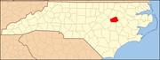
Elk Park is a town in Avery County, North Carolina, United States. The town was so named because of the number of elk killed there. The population was 452 at the 2010 census.

<span class="mw-page-title-main">Newland, North Carolina</span> Town in North Carolina, United States

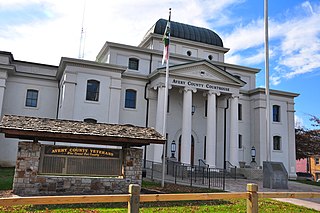
Newland is a town in Avery County, North Carolina, United States. The population was 698 at the 2010 census. It is the county seat of Avery County.

<span class="mw-page-title-main">Weldon, North Carolina</span> Town in North Carolina, United States

Weldon is a town in Halifax County, North Carolina, United States. The population was 1,655 at the 2010 census. It is part of the Roanoke Rapids, North Carolina Micropolitan Statistical Area.

<span class="mw-page-title-main">Benson, North Carolina</span> Town in North Carolina, United States

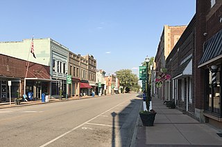
Benson is a town in Johnston County, North Carolina, United States, near the intersection of Interstates 95 and 40. Benson celebrates Mule Days on the fourth Saturday of September, a festival that attracts over 60,000 people each year. In 2010, the population was 3,311, up from 2,923 in 2000.

<span class="mw-page-title-main">Four Oaks, North Carolina</span> Town in North Carolina, United States

Four Oaks is a town in Johnston County, North Carolina, United States. As of the 2010 census it had a population of 1,921, up from 1,424 in 2000.

<span class="mw-page-title-main">Micro, North Carolina</span> Town in North Carolina, United States

Micro is a town in Johnston County, North Carolina, United States. The population was 458 as of the 2020 census, up from 441 in the 2010 census.

<span class="mw-page-title-main">Pine Level, Johnston County, North Carolina</span> Town in North Carolina, United States

Pine Level, chartered 1872, is a town in Johnston County, North Carolina, United States. The population was 1,700 at the 2010 census, up from 1,313 in 2000. Pine Level is located 35 miles (56 km) southeast of Raleigh, the state capital.

<span class="mw-page-title-main">Selma, North Carolina</span> Town in North Carolina, United States

Selma is a town in Johnston County, North Carolina, United States. In 2010, the population was 6,073, and as of 2018 the estimated population was 6,913. Selma is part of the Raleigh-Durham-Cary Combined Statistical Area. The area has a population over 1.7 million residents, though the town of Selma is able to maintain its rural character. The Everitt P. Stevens House, located in Selma, was the site of the last Grand Review of the Confederate Army held on April 6, 1865, after its defeat at the Battle of Bentonville.

<span class="mw-page-title-main">Smithfield, North Carolina</span> Town in North Carolina, United States

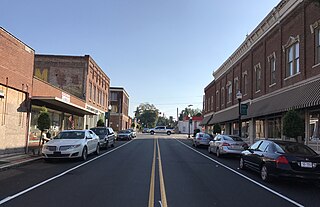
Smithfield is a town in and the county seat of Johnston County, North Carolina, United States. As of the 2010 census, its population was 10,966, and in 2019 the estimated population was 12,985. Smithfield is home to the Ava Gardner Museum and is situated along the Neuse River, where visitors enjoy the annual Smithfield Ham and Yam Festival, walks along the Buffalo Creek Greenway, and the historic downtown district. The town is located near North Carolina's Research Triangle and is about 30 miles (48 km) southeast of downtown Raleigh. The Raleigh-Durham-Cary combined statistical area has a population over 2 million residents.

<span class="mw-page-title-main">Biscoe, North Carolina</span> Town in North Carolina, United States

Biscoe is a town in Montgomery County, North Carolina, United States. The population was 1,700 at the 2010 census. The town is named after Henry Biscoe, an important customer of the local lumber business.

<span class="mw-page-title-main">Seaboard, North Carolina</span> Town in North Carolina, United States

Seaboard is a township in Northampton County, North Carolina, United States, created as a company town by the Seaboard and Roanoke Railroad, approximately 10 miles northeast of Weldon in the mid-1840s as a place for railroad employees to live.

<span class="mw-page-title-main">Bayboro, North Carolina</span> Town in North Carolina, United States

Bayboro is a town in Pamlico County, North Carolina, United States. The population was 1,161 at the 2020 U.S. census. It is the county seat of Pamlico County.

<span class="mw-page-title-main">Fremont, North Carolina</span> Town in North Carolina, United States

Fremont is a town in Wayne County, North Carolina, United States. The population was 1,255 at the 2010 census. It is included in the Goldsboro, North Carolina Metropolitan Statistical Area.

<span class="mw-page-title-main">Tishomingo, Oklahoma</span> City in Oklahoma

Tishomingo is the largest city in, and the county seat of, Johnston County, Oklahoma, United States. The population was 3,034 at the 2010 census, a decline of 4.1 percent from the figure of 3,162 in 2000. It was the first capital of the Chickasaw Nation, from 1856 until Oklahoma statehood in 1907. The city is home to Murray State College, a community college with an annual enrollment of 3,015 students. Tishomingo is part of the Texoma region.

<span class="mw-page-title-main">Barnwell, South Carolina</span> City in South Carolina, United States

Barnwell is a city in and county seat of Barnwell County, South Carolina, United States, located along U.S. Route 278. The population was 4,750 at the 2010 census.

<span class="mw-page-title-main">Latta, South Carolina</span> Town in South Carolina, United States

Latta is a town in Dillon County, South Carolina, United States. Latta is the second most populous town in Dillon County. As of the 2010 census, it had a population of 1,379.

<span class="mw-page-title-main">Johnston, South Carolina</span> Town in South Carolina, United States

Johnston is a town in Edgefield County, South Carolina, United States. The population was 2,362 at the 2010 census. It is part of the Augusta, Georgia, metropolitan area. The town's official welcome sign states that it is "Peach Capital of the World".

References

  1. "ArcGIS REST Services Directory". United States Census Bureau. Retrieved September 20, 2022.
  2. 1 2 U.S. Geological Survey Geographic Names Information System: Kenly, North Carolina
  3. 1 2 "U.S. Census website". United States Census Bureau . Retrieved January 31, 2008.
  4. 1 2 "Geographic Identifiers: 2010 Census Summary File 1 (G001): Kenly town, North Carolina". American Factfinder. U.S. Census Bureau. Archived from the original on February 13, 2020. Retrieved October 12, 2018.
  5. 1 2 Powell 1976, p. 262.
  6. Johnson & Barbour 1997, pp. 8–9.
  7. Johnson & Barbour 1997, p. 55.
  8. Johnson & Barbour 1997, p. 58.
  9. "Town of Kenly to investigate police resignations. What will happen next?" . Retrieved August 8, 2023.
  10. "Entire North Carolina police department resigns after new town manager is hired". Fox News . July 22, 2022.
  11. "An entire North Carolina police department resigned after a Black woman town manager was hired". CNN . July 29, 2022.
  12. "US Gazetteer files: 2010, 2000, and 1990". United States Census Bureau. February 12, 2011. Retrieved April 23, 2011.
  13. "Census of Population and Housing". Census.gov. Retrieved June 4, 2015.
  14. "Explore Census Data". data.census.gov. Retrieved December 23, 2021.
  15. "National Register Information System". National Register of Historic Places . National Park Service. July 9, 2010.

Works cited