Wilson County is a county located in the U.S. state of North Carolina. As of the 2020 census, the population was 78,784. The county seat is Wilson. The county comprises the Wilson, NC Micropolitan Statistical Area, which is also included within the Rocky Mount-Wilson-Roanoke Rapids, NC Combined Statistical Area.

West Harrison is a town in Harrison Township, Dearborn County, Indiana, United States. The population was 289 at the 2010 census.

Lagro is a town in Lagro Township, Wabash County, in the U.S. state of Indiana. The population was 415 at the 2010 census.

Cutler is a town in Washington County, Maine, United States. The town was named after Joseph Cutler, an early settler, who hailed from Newburyport, Massachusetts. The population was 524 at the 2020 census.

Sharptown is a town in Wicomico County, Maryland, United States. The population was 651 at the 2010 census. It is included in the Salisbury, Maryland-Delaware Metropolitan Statistical Area.
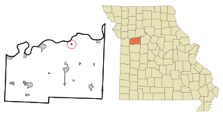
Dover is a town in Lafayette County, Missouri, and is part of the Kansas City metropolitan area within the United States. The population was 83 at the 2020 census.

Saint Stephen is a city in Stearns County, Minnesota, United States. The population was 797 at the 2020 census.

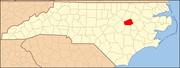
Winterville is a town in Pitt County, North Carolina, United States. The population was 10,591 as of the 2020 census. The town is a part of the Greenville Metropolitan Area.

West Hamlin is a town in Lincoln County, West Virginia, United States, along the Guyandotte River. The population was 519 at the 2020 census, and is now down to 509, according to the 2021 census. West Hamlin is a part of the Huntington-Ashland, WV-KY-OH, Metropolitan Statistical Area (MSA). West Hamlin is west of the county seat at Hamlin, hence the name.

Cameron is a city in Marshall County, West Virginia, United States. It is part of the Wheeling metropolitan area. The population was 849 at the 2020 census.

Leon is a town in Mason County, West Virginia, United States, situated along the Kanawha River. The population was 137 at the 2020 census. It is part of the Point Pleasant, WV–OH Micropolitan Statistical Area.

Carpendale is a town in Mineral County, West Virginia, United States, and part of the Cumberland, MD-WV Metropolitan Statistical Area'. The population was 861 at the 2020 census. Carpendale was incorporated on January 2, 1990, by the Circuit Court. The town is a combination of three subdivisions of which its name reflects: Carpenters Addition, Millerdale I, and Millerdale II. There are no stores in Carpendale and there is only one road in and out of the town.

Durbin is a town in Pocahontas County, West Virginia, United States. The population was 235 at the 2020 census.

Cairo is a town in Ritchie County, West Virginia, United States, along West Virginia Route 31, the North Fork of the Hughes River, and the North Bend Rail Trail. The population was 174 at the 2020 census.
Davis is a town in Tucker County, West Virginia, United States, situated along the Blackwater River. The population was 595 at the 2020 census.

Friendly is a town in Tyler County, West Virginia, United States. The population was 100 at the 2020 census.

Sherman is a town in Iron County, Wisconsin, United States. The population was 336 at the 2000 census. The unincorporated communities of Powell and Springstead are located in the town. The Lac du Flambeau Band of Lake Superior Chippewa is located partially in the town.

Washington is a town in Sauk County, Wisconsin, United States. The population was 904 at the 2000 census. The unincorporated communities of Hill Point and Sandusky are located in the town.
Pigeon is a town in Trempealeau County, Wisconsin, United States. The population was 894 at the 2000 census. The unincorporated community of Coral City is located in the town.
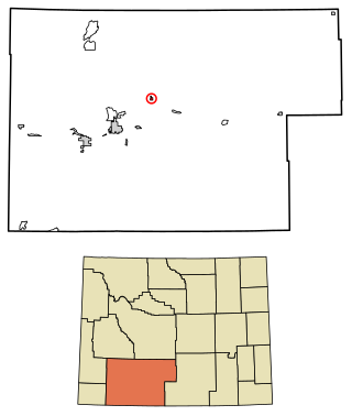
Superior is a town in Sweetwater County, Wyoming, United States. The population was 336 at the 2010 census.