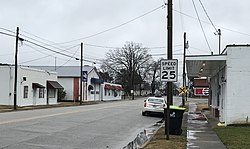
Micro, North Carolina | |
---|---|
Coordinates: 35°33′45″N78°12′13″W / 35.56250°N 78.20361°W | |
Country | United States |
State | North Carolina |
County | Johnston |
Area | |
• Total | 0.42 sq mi (1.09 km2) |
• Land | 0.42 sq mi (1.09 km2) |
• Water | 0.00 sq mi (0.00 km2) |
Elevation | 194 ft (59 m) |
Population (2020) | |
• Total | 458 |
• Density | 1,093.08/sq mi (421.75/km2) |
Time zone | UTC-5 (Eastern (EST)) |
• Summer (DST) | UTC-4 (EDT) |
ZIP code | 27555 |
Area code | 919 |
FIPS code | 37-42620 [3] |
GNIS feature ID | 2406155 [2] |
Micro is a town in Johnston County, North Carolina, United States. The population was 458 as of the 2020 census, up from 441 in the 2010 census. [4]
The community was settled in about 1890, [5] developing along the "Short-Cut" rail line of the Wilmington and Weldon Railroad. [6] [7] It was incorporated nine years later as Jerome, being named for local landowner Jerome Creech. The name was changed to Micro in 1905 to avoid confusion with the Jerome community in Bladen County. [5] A wooden school for white children was built that year. It was replaced by a brick building in 1924, which operated until 1987. [8]
According to the United States Census Bureau, the town has a total area of 0.4 square miles (1.0 km2), all land.
Census | Pop. | Note | %± |
---|---|---|---|
1900 | 61 | — | |
1910 | 74 | 21.3% | |
1920 | 183 | 147.3% | |
1930 | 222 | 21.3% | |
1940 | 289 | 30.2% | |
1950 | 310 | 7.3% | |
1960 | 350 | 12.9% | |
1970 | 300 | −14.3% | |
1980 | 438 | 46.0% | |
1990 | 417 | −4.8% | |
2000 | 454 | 8.9% | |
2010 | 441 | −2.9% | |
2020 | 458 | 3.9% | |
2023 (est.) | 508 | [9] | 10.9% |
U.S. Decennial Census [10] |
Micro is the least-populated incorporated community in Johnston County. [6] As of the census [3] of 2000, there were 454 people, 211 households, and 124 families residing in the town. The population density was 1,114.9 inhabitants per square mile (430.5/km2). There were 225 housing units at an average density of 552.5 per square mile (213.3/km2). The racial makeup of the town was 90.97% White, 7.71% African American, 1.10% from other races, and 0.22% from two or more races. Hispanic or Latino of any race were 3.96% of the population.
There were 211 households, out of which 25.1% had children under the age of 18 living with them, 43.6% were married couples living together, 12.3% had a female householder with no husband present, and 41.2% were non-families. 39.8% of all households were made up of individuals, and 24.2% had someone living alone who was 65 years of age or older. The average household size was 2.15 and the average family size was 2.88.
In the town, the population was spread out, with 22.7% under the age of 18, 7.3% from 18 to 24, 26.0% from 25 to 44, 22.2% from 45 to 64, and 21.8% who were 65 years of age or older. The median age was 40 years. For every 100 females, there were 85.3 males. For every 100 females age 18 and over, there were 75.5 males.
The median income for a household in the town was $28,889, and the median income for a family was $39,773. Males had a median income of $30,962 versus $20,000 for females. The per capita income for the town was $15,629. About 1.4% of families and 8.3% of the population were below the poverty line, including 4.1% of those under age 18 and 27.9% of those age 65 or over.
Micro is led by a four-member town commission composed of three commissioners and a mayor all elected at-large. The mayor does not vote in commission meetings. The town maintains its own police department. [11]
Wilson County is a county located in the U.S. state of North Carolina. As of the 2020 census, the population was 78,784. The county seat is Wilson. The county comprises the Wilson, NC Micropolitan Statistical Area, which is also included within the Rocky Mount-Wilson-Roanoke Rapids, NC Combined Statistical Area.
Johnston County is a county located in the U.S. state of North Carolina. As of the 2020 census, the population was 215,999. Its county seat is Smithfield.
Wadesboro is a town and the county seat of Anson County, North Carolina, United States. The population was 5,008 at the 2020 census. The town was originally found in 1783 as New Town but changed by the North Carolina General Assembly to Wadesboro in 1787 to honor Colonel Thomas Wade, a native son, state legislator, and Revolutionary War commander of the Anson County Regiment.
St. James or Saint James is a town in Brunswick County, North Carolina, United States. The population was 3,165 at the 2010 census, up from 804 in 2000. It is part of the Wilmington, NC Metropolitan Statistical Area.
Benson is a town in Johnston County, North Carolina, United States, near the intersection of Interstates 95 and 40. Benson celebrates Mule Days on the fourth Saturday of September, a festival that attracts over 60,000 people each year. In 2010, the population was 3,311, up from 2,923 in 2000.
Clayton is a town in Johnston County, North Carolina, United States, and is considered a satellite town of Raleigh. As of 2010, Clayton's population was 16,116, up from 6,973 at the 2000 census. By 2019 the town's estimated population was 24,887. Much of that growth can be attributed to the town's proximity to the Research Triangle area and access to major highways such as I-40 and US 70.
Four Oaks is a town in Johnston County, North Carolina, United States. As of the 2010 census it had a population of 1,921, up from 1,424 in 2000.
Pine Level, chartered 1872, is a town in Johnston County, North Carolina, United States. The population was 1,700 at the 2010 census, up from 1,313 in 2000. Pine Level is located 35 miles (56 km) southeast of Raleigh, the state capital.
Princeton is a town in Johnston County, North Carolina, United States. As of the 2010 census it had a population of 1,194. Each May the town celebrates Princeton Community Day, a festival dedicated to promoting community involvement and town pride. The town holds municipal elections in November in odd-number years to elect its mayor and town council.
Selma is a town in Johnston County, North Carolina, United States. In 2010, the population was 6,073, and as of 2018 the estimated population was 6,913. Selma is part of the Raleigh-Durham-Cary Combined Statistical Area. The area has a population over 1.7 million residents, though the town of Selma is able to maintain its rural character. The Everitt P. Stevens House, located in Selma, was the site of the last Grand Review of the Confederate Army held on April 6, 1865, after its defeat at the Battle of Bentonville.
Smithfield is a town in and the county seat of Johnston County, North Carolina, United States. As of the 2010 census, its population was 10,966, and in 2019 the estimated population was 12,985. Smithfield is home to the Ava Gardner Museum and is situated along the Neuse River, where visitors enjoy the annual Smithfield Ham and Yam Festival, walks along the Buffalo Creek Greenway, and the historic downtown district. The town is located near North Carolina's Research Triangle and is about 30 miles (48 km) southeast of downtown Raleigh. The Raleigh-Durham-Cary combined statistical area has a population over 2 million residents.
West Smithfield was an unincorporated community and census-designated place and is now a district of Smithfield, North Carolina in Johnston County, North Carolina, United States. The population was last recorded separately from Smithfield in 2000, when 59 people resided in the CDP.
Wilson's Mills is a town in Johnston County, North Carolina, United States. In 2010, the population was 2,277, up from 1,291 in 2000. As of 2018, the estimated population was 2,689.
Rutherfordton is a town and the county seat of Rutherford County, North Carolina, United States. The population was 4,213 at the 2010 census.
Richfield is a town in Stanly County, North Carolina, United States. The town was originally called "Ritchie's Field," for the prominent Ritchie family who established the post office, sawmill, and streets of the settlement.
Ronda is a town in Wilkes County, North Carolina, United States. The population was 417 at the 2010 census, and 413 at the 2020 census. Ronda was named after a nearby estate called "Roundabout", which was the residence of Benjamin Cleveland, a locally prominent planter and a colonel in the North Carolina militia during the Revolutionary War. The town is home to East Wilkes High School, one of Wilkes County's five public high schools.
Meggett is a town in Charleston County, South Carolina, United States. The population was 1,226 at the 2010 census. Meggett is part of the Charleston-North Charleston-Summerville metropolitan area.
Johnston is a town in Edgefield County, South Carolina, United States. The population was 2,362 at the 2010 census. It is part of the Augusta, Georgia, metropolitan area. The town's official welcome sign states that it is "Peach Capital of the World".
Kenly is a town in Johnston and Wilson counties in the U.S. state of North Carolina. It was named for John R. Kenly, Northern Division Superintendent of the Atlantic Coast Line Railroad, who later became president of the railroad in 1913. The population was 1,339 at the 2010 census, down from 1,569 in 2000.
Weddington is a suburban town in Union County, North Carolina, United States. The population was 9,459 at the 2010 census. It is a suburb in the Charlotte metropolitan area. The current mayor of Weddington is Jim Bell.