Selma, North Carolina | |
|---|---|
 Downtown Selma | |
 Flag  Seal Logo | |
| Motto: "The Crossroads of Tradition and Innovation" | |
 Location of Selma, North Carolina | |
| Coordinates: 35°32′27″N78°17′35″W / 35.54083°N 78.29306°W | |
| Country | United States |
| State | North Carolina |
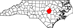
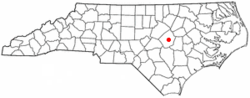
| County | Johnston |
| Chartered | February 11, 1873 |
| Named after | Selma, Alabama |
| Government | |
| • Type | Council–manager |
| • Mayor | Byron McAllister |
| Area | |
• Total | 5.41 sq mi (14.00 km2) |
| • Land | 5.41 sq mi (14.00 km2) |
| • Water | 0 sq mi (0.00 km2) |
| Elevation | 164 ft (50 m) |
| Population (2020) | |
• Total | 6,317 |
| • Density | 1,168.9/sq mi (451.33/km2) |
| Time zone | UTC-5 (Eastern (EST)) |
| • Summer (DST) | UTC-4 (EDT) |
| ZIP code | 27576 |
| Area code | 919 |
| FIPS code | 37-60320 [3] |
| GNIS feature ID | 2407310 [2] |
| Website | www |
Selma is a town in Johnston County, North Carolina, United States. In 2010, its population was 6,073, [4] and as of 2018, the estimated population was 6,913. [5] Selma is part of the Raleigh-Durham-Cary combined statistical area. The area has a population over 1.7 million residents, though the town of Selma is able to maintain its rural character. The Everitt P. Stevens House, located in Selma, was the site of the last Grand Review of the Confederate Army held on April 6, 1865, after its defeat at the Battle of Bentonville.
Contents
- History
- Geography
- Demographics
- 2020 census
- 2000 census
- Religion
- Law and government
- Transportation
- Air
- Designated routes and highways
- Passenger rail service
- Commercial rail service
- Public transit
- Education
- Culture
- Museums
- Media
- Television
- Newspapers
- Radio stations
- Notable people
- References
- External links