Morrisville, North Carolina

Last updated

Morrisville, North Carolina
Morrisville, North Carolina (2014).jpg
Morrisville town limit sign
Williamson Page House 2013-09-21 17-58-55.jpg
Page House
The Pugh House in Morrisville NC.jpg
Pugh House
Lake Crabtree.jpg
Lake Crabtree
Chruch Street Park during a MLC game in 2023.jpg
Church Street Park
Morrisville, NC Town Flag.jpg
Morrisville, NC Town Seal.jpg
Morrisville NC Town Logo.png
Motto: 
"Live Connected. Live Well."
Wake County North Carolina incorporated and unincorporated areas Morrisville highlighted.svg
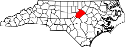
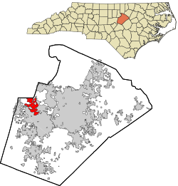
Location in Wake County and the state of North Carolina.
Coordinates: 35°48′57″N78°50′21″W / 35.81583°N 78.83917°W / 35.81583; -78.83917
Country Flag of the United States (23px).png  United States
State Flag of North Carolina.svg North Carolina
Counties Wake, Durham
Founded1852
Incorporated March 3, 1875
Government
  Type Council-manager government
  BodyMorrisville Town Council
   Mayor T.J. Cawley (Ind.)
Area
[1]
  Total
8.89 sq mi (23.02 km2)
  Land8.83 sq mi (22.86 km2)
  Water0.06 sq mi (0.16 km2)
Elevation
[2]
299 ft (91 m)
Population
 (2020)
  Total
29,630
  Density3,356.75/sq mi (1,296.00/km2)
Time zone UTC−5 (Eastern (EST))
  Summer (DST) UTC−4 (EDT)
ZIP codes
27519, 27560
Area code 919 & 984
FIPS code 37-44520 [3]
GNIS feature ID2406198 [2]
Website morrisvillenc.gov

Morrisville is a town located primarily in Wake County, North Carolina, United States (a small portion extends into neighboring Durham County). [4] [5] According to the 2020 census, the population was 29,630. [6] Morrisville is part of the Research Triangle metropolitan region, located midway between the cities of Raleigh and Durham. The Research Triangle region encompasses the Raleigh-Durham-Cary, NC Combined Statistical Area. The operational headquarters of Lenovo is located in the municipal limits.

Contents

History

The area was originally named in 1852 after Jeremiah Morris. Morris donated land to the North Carolina Railroad for a depot, water tower, and other buildings. The town continued to grow as a result of the rail line and its location at the intersection of roads leading to Chapel Hill, Raleigh, and Hillsborough.

On April 13, 1865, in the Battle of Morrisville, United States cavalry under the command of Gen. Judson Kilpatrick skirmished with the retreating Confederate armies at Morrisville Station. The Confederate troops were successful in evacuating their remaining supplies and wounded to the west toward Greensboro, but Gen. William Tecumseh Sherman's cavalry forced the Confederates to leave the train behind and retreat toward Durham and the eventual surrender of the largest Confederate force of the war at Bennett Place. [7] [ original research? ]

The town was officially chartered in 1875 but was disincorporated in 1933. Eventually the town charter was restored in 1947. [8]

Morrisville History (as listed on historical marker):

Morrisville Station: "On April 16, 1865, Union cavalry under the command of General William T. Sherman, captured Raleigh and pursued the retreating Confederate cavalry west along the railroad. Rearguard skirmishes erupted at points along the Hillsborough Road until the combatants reached Morrisville. Using cavalry and artillery, Union forces attacked a Confederate train loaded with supplies and wounded. Before withdrawing, the Confederate cavalry repelled the attack long enough to allow the railcars of wounded to escape while abandoning the supplies. This was the last major cavalry engagement in Sherman's campaign. The next night, a courier from the Confederate commander, General Joseph E. Johnston, rode into the Union camp at Morrisville with a truce proposal. Subsequent negotiations between Johnston and Sherman led to the largest Confederate surrender of the Civil War at the Bennett Farm in Durham on April 26."

The history marker notes it was given in memory of Commissioner C.T. Moore. [9]

On December 13, 1994, Flagship Airlines Flight 3379 crashed in Morrisville, killing 15 of the 20 people on board. [10]

Geography

According to the United States Census Bureau, the town has a total area of 8.3 square miles (21.5 km2), of which 8.3 square miles (21.4 km2) is land and 0.04 square miles (0.1 km2), or 0.62%, is water. [11]

Morrisville is located in the northeast central region of North Carolina, where the North American Piedmont and Atlantic Coastal Plain regions meet. This area is known as the "Fall Line" because it marks the elevation inland at which waterfalls begin to appear in creeks and rivers. As a result, most of Morrisville features gently rolling hills that slope eastward toward the state's flat coastal plain. Its central Piedmont location situates the county approximately three hours west of Atlantic Beach by car and four hours east of the Great Smoky Mountains.

The central core of Morrisville is located along the upper portion of Crabtree Creek, which then feeds into Lake Crabtree, located in the southeastern part of the town.

Climate

Morrisville enjoys a moderate subtropical climate, with moderate temperatures in the spring, fall, and winter. Summers are typically hot with high humidity. Winter highs generally range in the low 50s°F (10 to 13 °C) with lows in the low-to-mid 30s°F (-2 to 2 °C), although an occasional 60 °F (16 °C) or warmer winter day is not uncommon. This is canceled out, however, with several days where highs do not get out of the 30s. There are usually one or two substantial snowfalls per winter, occurring mainly in February. Spring and fall days usually reach the low-to-mid 70s°F (low 20s°C), with lows at night in the lower 50s°F (10 to 14 °C). Summer daytime highs often reach the upper 80s to low 90s°F (29 to 35 °C). The rainiest months are July and August.

Demographics

Historical population
CensusPop.Note
1880 165
1890 149−9.7%
1900 100−32.9%
1910 15151.0%
1920 1669.9%
1930 161−3.0%
1950 221
1960 2220.5%
1970 209−5.9%
1980 25120.1%
1990 1,022307.2%
2000 5,208409.6%
2010 18,576256.7%
2020 29,63059.5%
U.S. Decennial Census [12]

2020 census

Morrisville racial composition [13]
RaceNumberPercentage
White (non-Hispanic)10,07434.0%
Black or African American (non-Hispanic)2,8809.72%
Native American 800.27%
Asian 13,70046.24%
Pacific Islander 50.02%
Other/Mixed 1,1773.97%
Hispanic or Latino 1,7145.78%

As of the 2020 United States census, there were 29,630 people, 9,699 households, and 6,781 families residing in the town.

2015 census estimate

As of the 2015 census estimate, the population of the town was 23,699.

2010 census

As of the 2010 census there were 18,576 people, 7,641 households, and 4,752 families residing in the town. The population density was 2,237.7 inhabitants per square mile (864.0/km2). There were 8,357 housing units at an average density of 1,006.9 units per square mile (388.8 units/km2). Known as North Carolina's "little India" by locals, [14] Morrisville has become one of the most diverse towns in the state particularly due to the expansion of the technology industry. [15] The racial makeup of the town was 54.0% White, 12.9% African American, 0.4% Native American, 27.2% Asian, 2.0% from some other race, and 3.4% from two or more races. Hispanic or Latino of any race were 5.9% of the population. [16]

There were 7,641 households, out of which 37.1% had children under the age of 18 living with them. 50.3% of all households were headed by married couples living together, 8.9% had a female householder with no husband present, and 37.8% were non-families. 30.0% of all households were made up of individuals, and 2.5% had someone living alone who was 65 years of age or older. The average household size was 2.43, and the average family size was 3.11. [16]

In the town, the population was spread out, with 27.0% under the age of 18, 6.0% from 18 to 24, 44.4% from 25 to 44, 18.4% from 45 to 64, and 4.3% who were 65 years of age or older. The median age was 32.5 years. For every 100 females, there were 96.7 males. For every 100 females age 18 and over, there were 93.2 males. [16]

In 2017, the median income for a household in the town was $95,763. Males had a median income of $59,982 versus $44,729 for females. The per capita income for the town was $43,054. About 3.4% of families and 4.6% of the population were below the poverty line, including 4.1% of those under age 18 and 13.0% of those age 65 or over. [3]

Economy

Morrisville's location adjacent to the Research Triangle Park, Raleigh-Durham International Airport, and Interstate 40 makes it an attractive location for offices, light industry and hotels. Companies based in Morrisville include Oracle, Syneos Health and Lenovo (operational headquarters). [17]

Prior to its disestablishment, Midway Airlines had its headquarters in Morrisville. [18]

The Morrisville Chamber of Commerce serves as the economic development arm for the town.

Employers

The computer technology, clinical trial and telecommunications industries have strong presence in the area. [19] Major employers in 2019 included: [20]

Arts and culture

National Register of Historic Places

The Morrisville Christian Church, Williamson Page House, and Pugh House are listed on the National Register of Historic Places. [21] [22] [23]

Parks and recreation

Shiloh Park View of historic Shiloh.png
Shiloh Park

Morrisville is home to eight parks, [24] two community centers, four greenways and a fitness center. Morrisville has several youth sports groups, such as youth basketball, [25] baseball, softball, soccer, [26] and cricket. [27]

List of Parks

NameSizeNotes
Morrisville Community Park35-acre (140,000 m2) [28] Includes Hatcher Creek greenway in addition to rentable shelters, athletic fields, gazebo and picnic shelters [29]
Shiloh Community Park & Luther Green Center8-acre (32,000 m2) [28] Includes athletic field, picnic shelters, basketball court and playground [30]
Crabtree Creek Nature Park37-acre (150,000 m2) [28] Wooded and wetland site with a multi-purpose field [31]
Ruritan Park0.5-acre (2,000 m2) [28] Includes a gazebo, open areas, [32] and sand volleyball courts. [33] Owned by Ruritan Club and maintained by town. [28]
Indian Creek Greenway and Trailhead17-acre (69,000 m2) [28] Includes two picnic shelters, a playground, restrooms, and a 1.8-mile trail [34]
Cedar Fork District Park34-acre (140,000 m2) [28] Includes eight multi-purpose fields [35]
Church Street Park 25-acre (100,000 m2) [28] Includes a cricket pitch and tennis courts. [36]
Northwest Park5-acre (20,000 m2) [28] Open seating and compact playground surrounded by a walking path
Lake Crabtree County Park 250-acre (1,000,000 m2) park

520-acre (2,100,000 m2) lake

Includes boating facilities, trails, playground, and picnic shelters. [37]
Raleigh-Durham International Airport Observation ParkIncludes observation platform and picnic area. [38]
Cedar Fork Community Center6-acre (24,000 m2) [28] Includes classrooms, gym, and field shared with Cedar Fork Elementary.
Morrisville Aquatics and Fitness Center5-acre (20,000 m2) [28] Includes gym, pools, tennis courts, and racquetball court.
Shiloh Park Shiloh Park.png
Shiloh Park

Government

Morrisville operates under the council–manager form of government. The citizens elect a mayor and town council as the town's governing body. After each municipal election, the town council selects a mayor pro tem. The town manager, Martha Paige, is appointed by the council to serve as the chief operating officer administering all municipal affairs. [39] The current mayor is TJ Cawley and mayor pro tem is Liz Johnson. Morrisville Council members include Steve Rao, Vicki Scroggins-Johnson, Satish Garimella, Anne Robotti, and Donna Fender. [40]

The North Carolina State Board of Dental Examiners has its headquarters in Morrisville. [41]

Infrastructure

Transportation

Public Transit

Triangle Transit 2008-07-05 TTA bus 713 at DATA terminal.jpg
Triangle Transit

GoTriangle operates buses that serve the region and connect to municipal bus systems in Raleigh, Durham, Cary, and Chapel Hill. The Morrisville Smart Shuttle, operated by GoCary, serves the town with on-demand fare-free transit.

Morrisville is not served directly by passenger trains. Amtrak serves the nearby municipalities of Cary and Raleigh. The North Carolina Railroad passes through the town.

Air

Raleigh-Durham International Airport is located in northwestern Wake county on I-40, just to the north of Morrisville.

Roads & Highways

  • NC 54.svg NC 54 is a major highway that goes through town and provides easy access to Cary, Raleigh, Durham and Chapel Hill.
  • I-40.svg I-40 runs through the eastern part of the town.
  • I-540.svgNC 540.svg I-540  / NC 540 serves the Morrisville area and is located to the west of the town. The highway offers access to I-40, North Raleigh, RDU airport and eastern Wake County.
  • NC 147.svg NC 147 is located in the northern part of town and provides easy access to Durham.

Utilities

Water and wastewater services are provided by the Town of Cary. Cary sources water from Jordan Lake. Electricity is provided by Duke Energy and Natural Gas is provided by Dominion Energy. Solid waste collection is contracted by the town to GFL Environmental.

Notable people

References

  1. "ArcGIS REST Services Directory". United States Census Bureau. Retrieved September 20, 2022.
  2. 1 2 U.S. Geological Survey Geographic Names Information System: Morrisville, North Carolina
  3. 1 2 "U.S. Census website". United States Census Bureau . Retrieved January 31, 2008.
  4. "General Information". Town of Morrisville. Archived from the original on June 9, 2011. Retrieved June 16, 2010.
  5. "P.L. 94-171 County Block Map (2010 Census): Wake County, NC (Map Sheet 17)" (PDF). U.S. Census Bureau. Retrieved December 30, 2011.
  6. "QuickFacts: Morrisville town, North Carolina". United States Census Bureau. Retrieved January 3, 2023.
  7. Dollar, Ernest. "Morrisville History". Archived from the original on May 12, 2008. Retrieved June 16, 2010.
  8. "History | Town of Morrisville, NC". www.morrisvillenc.gov. Archived from the original on March 28, 2025. Retrieved May 30, 2025.
  9. "Morrisville Historical Marker". Archived from the original on February 2, 2016. Retrieved October 9, 2011.
  10. "Uncontrolled collision with terrain, Flagship Airlines, Inc., dba American Eagle Flight 3379, BAe Jetstream 3201, N918AE, Morrisville, North Carolina, December 13, 1994" (PDF). National Transportation Safety Board. October 24, 1995. NTSB/AAR-95/07. Retrieved December 16, 2019.
  11. "Geographic Identifiers: 2010 Demographic Profile Data (G001): Morrisville town, North Carolina". United States Census Bureau . Retrieved December 30, 2011.
  12. "Census of Population and Housing". Census.gov. Retrieved June 4, 2016.
  13. "Explore Census Data". data.census.gov. Retrieved December 20, 2021.
  14. Kurry, Dawn (November 29, 2013). "Triangle's Little India". Triangle Business Journal. Retrieved June 15, 2014.
  15. "Morrisville Demographics". Archived from the original on June 12, 2013.
  16. 1 2 3 "Profile of General Population and Housing Characteristics: 2010 Demographic Profile Data (DP-1): Morrisville town, North Carolina". United States Census Bureau . Retrieved December 30, 2011.
  17. "Locations – Lenovo US". Lenovo. Archived from the original on July 6, 2020. Retrieved July 4, 2020.
  18. "Corporate Information". Midway Airlines. April 18, 2000. Archived from the original on April 18, 2000. Retrieved January 29, 2010.
  19. "Major Employers of Morrisville". Choose Morrisville. Retrieved April 13, 2015.
  20. "Morrisville Municipal Profile 2019" (PDF). Morrisville Chamber of Commerce. 2019.
  21. "National Register of Historic Places Listings" (PDF). Weekly List of Actions Taken on Properties: 11/05/12 through 11/09/12. National Park Service. July 3, 2014.
  22. "National Register of Historic Places Listings" (PDF). Weekly List of Actions Taken on Properties: 4/16/12 through 4/20/12. National Park Service. April 27, 2012.
  23. "National Register of Historic Places Listings" (PDF). Weekly List of Actions Taken on Properties: 6/16/14 through 6/27/14. National Park Service. July 3, 2014.
  24. "Parks and Greenways". Town of Morrisville. Archived from the original on June 9, 2011. Retrieved June 16, 2010.
  25. "Youth Basketball". Town of Morrisville. Archived from the original on June 9, 2011. Retrieved June 16, 2010.
  26. "Athletics". Town of Morrisville. Archived from the original on February 22, 2010. Retrieved June 16, 2010.
  27. "Youth Cricket". Town of Morrisville. Archived from the original on June 9, 2011. Retrieved June 16, 2010.
  28. 1 2 3 4 5 6 7 8 9 10 11 "Wayback Machine". www.morrisvillenc.gov. Archived from the original on January 21, 2025. Retrieved April 6, 2025.
  29. "Morrisville Community Park". Town of Morrisville. Archived from the original on September 12, 2010. Retrieved June 16, 2010.
  30. "Shiloh Park / Luthor Green Center". Town of Morrisville. Archived from the original on June 9, 2011. Retrieved June 16, 2010.
  31. "Crabtree Creek Nature Park". Town of Morrisville. Archived from the original on June 9, 2011. Retrieved June 16, 2010.
  32. "Ruritan Park". Town of Morrisville. Archived from the original on June 9, 2011. Retrieved June 16, 2010.
  33. "Ruritan Park". ParkGeek.com. Retrieved June 16, 2020.
  34. "Indian Creek Greenway and Trailhead". Town of Morrisville. Archived from the original on June 9, 2011. Retrieved June 16, 2010.
  35. "Cedar Fork District Park". Town of Morrisville. Archived from the original on June 9, 2011. Retrieved June 16, 2010.
  36. Doran, Will (December 29, 2014). "Morrisville gears up for new parks". cary news. Retrieved April 14, 2015.
  37. "Lake Crabtree County Park". Wake County Government. Retrieved April 6, 2025.
  38. Airport, Raleigh-Durham International. "Observation Park". Raleigh-Durham International Airport. Retrieved April 6, 2025.
  39. "Town Council". Town of Morrisville. Archived from the original on January 14, 2014. Retrieved February 22, 2014.
  40. "Council Members". Town of Morrisville. Archived from the original on January 14, 2014. Retrieved March 14, 2014.
  41. "Home." North Carolina State Board of Dental Examiners. Retrieved on May 15, 2013. "507 Airport Boulevard, Suite 105 Morrisville, NC 27560-8200"
  42. David Ray Boggs Owner Statistics. Racing-Reference. Retrieved October 29, 2020.
  43. Hill Carrow | Sports Destination Management. Retrieved October 29, 2020.
  44. Campbell, Colin. (January 30, 2015). Former Rep. Tom Murry lands legal counsel job at NC Administrative Office of the Courts. The News & Observer. Retrieved October 29, 2020.
  45. Sybil H. Argintar (September 2013). "Pugh House" (PDF). National Register of Historic Places - Nomination and Inventory. North Carolina State Historic Preservation Office. Retrieved June 1, 2015.
  46. Vic Sorrell Stats. Baseball-Reference. Retrieved October 29, 2020.