Riley Hill, North Carolina

Last updated

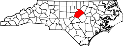
Riley Hill, North Carolina, United States, is an unincorporated community in mideastern Wake County. It is at the southern end of Broughton Road, on Riley Hill Road and is approximately six miles northeast of Knightdale, and approximately 3.8 miles north of the intersection of U.S. 64/264, and Business U.S. 64.

Perry Farm, listed on the National Register of Historic Places, is located in Riley Hill.

Coordinates: 35°51′32″N78°25′12″W / 35.8587634°N 78.4199993°W / 35.8587634; -78.4199993


Related Research Articles

Riley County, Kansas County in Kansas, United States

Riley County is a county located in the U.S. state of Kansas. As of the 2020 census, the population was 71,959. The largest city and county seat is Manhattan.

White County, Arkansas County in Arkansas, United States

White County is a county located in the U.S. state of Arkansas. As of the 2010 census, the population was 77,076. The county seat is Searcy. White County is Arkansas's 31st county, formed on October 23, 1835, from portions of Independence, Jackson, and Pulaski counties and named for Hugh Lawson White, a Whig candidate for President of the United States. It is an alcohol prohibition or dry county, though a few private establishments can serve alcohol.

Langdon Place, Kentucky City in Kentucky, United States

Langdon Place is a home rule-class city in Jefferson County, Kentucky, United States. The population was 936 as of the 2010 census.

Clarksville, Allegany County, New York Town in New York, United States

Clarksville is a town located in Allegany County, New York, United States. As of the 2010 census, the town had a total population of 1,161. The town is named after S.N. Clark, an agent of the Holland Land Company.

Tribes Hill, New York CDP in New York, United States

Tribes Hill is a census-designated place (CDP) located in the Towns of Mohawk (80%) and Amsterdam (20%) in Montgomery County, New York, United States. The population was 1,003 at the 2010 census. One theory is the name is based on this location having been a gathering spot for the Mohawk nation, the dominant Iroquois tribe in the area during colonial times.

Hartland, New York Town in New York, United States

Hartland is a town in Niagara County, New York, United States. The population was 4,117 at the 2010 census. The town is named after Hartland, Vermont, the homeplace of some early settlers.

Linden, North Carolina Town in North Carolina, United States

Linden is a town in Cumberland County, North Carolina, United States. The population was 130 at the 2010 census, the mayor is Frances Collier.

Bunn, North Carolina Town in North Carolina, United States

Bunn is a town in Franklin County, North Carolina, United States. The population was 344 at the 2010 census.

Mint Hill, North Carolina Town in North Carolina, United States

Mint Hill is a suburban town in southeastern Mecklenburg and northwestern Union counties in the U.S. state of North Carolina, it is a major suburb on the outskirts of Charlotte and near the Cabarrus County line. The population was 22,722 at the 2010 census.

Knightdale, North Carolina Town in North Carolina, United States

Knightdale is a town in Wake County, North Carolina, United States. As of the 2010 census, the population was 11,401. The U.S. Census Bureau estimates the town's population to be 17,843 as of July 1, 2019. Knightdale's population grew 10.4% from 2010-2013, making it the second fastest-growing community in the Research Triangle region for that time period.

River Road, Washington Census-designated place in Washington, United States

River Road is a census-designated place (CDP) in Clallam County, Washington, United States. The population was 454 at the 2010 census. It is a primarily residential area next to the city of Sequim.

Faison, North Carolina Town in North Carolina, United States

Faison is a town in Duplin County in the U.S. state of North Carolina. The population was 961 at the 2010 census.

Lockport (town), New York Town in New York, United States

Lockport is a town in Niagara County, New York, United States. The population was 20,529 at the 2010 census. The name is derived from the series of canal locks on the Erie Canal. The locks lift boats from the lowland of Lake Ontario past the Niagara Escarpment.

U.S. Route 11 or U.S. Highway 11 is a major north–south United States highway extending 1,645 miles (2,647 km) across the eastern United States. The southern terminus of the route is at U.S. Route 90 in the Bayou Sauvage National Wildlife Refuge in eastern New Orleans, Louisiana. The northern terminus is at the Rouses Point–Lacolle 223 Border Crossing in Rouses Point, New York. The route continues across the border into Canada as Quebec Route 223. US 11, created in 1926, maintains most of its original route. The route north of Knoxville, TN follows a route similar to I-81.

El Paso, Arkansas Unincorporated community in southwestern White County, Arkansas

El Paso is an unincorporated community in southwestern White County, Arkansas, United States. Its name is Spanish for "the pass", referring to a small gap in the hills on the community's northern edge. Once known as Peach Orchard Gap in its early settlement, the origin of El Paso's Spanish name is unknown.

U.S. Route 19W traverses approximately 63 miles (101 km) from Cane River, North Carolina to Bluff City, Tennessee.

Eagle Rock is an unincorporated community in Wake County, North Carolina, United States. It is located at 35°47'28N 78°24'31W, and is approximately 4 miles (6.4 km) east of Knightdale, and 2.25 miles (3.62 km) northwest of Wendell, just to the southeast of the interchange of US 64 and US 64-Business. Southeastern Free Will Baptist College lies within the community. The Hood-Anderson Farm is located in Eagle Rock and is listed on the National Register of Historic Places.

Geography of Memphis, Tennessee

The City of Memphis is located on the eastern bank of the Mississippi River in the southwest corner of the U.S. state of Tennessee. It is the regional hub for a tri-state area of Arkansas, Mississippi and Tennessee.

Stony Hill is an unincorporated community in Wake County, North Carolina, United States at an elevation of 407 feet or 124 m. The center of the community is at the intersection of North Carolina Highway 98 and Stony Hill Road. There is a fire station further north on Stony Hill Road.

Riley is an unincorporated community in southern Franklin County, North Carolina, United States near the Wake County line. It is located west-southwest of Bunn, at an elevation of 387 feet. The primary cross roads where the community is located are Pilot-Riley Road, Bethlehem Church Road and Old Halifax Road.