Garner, North Carolina

Last updated

Garner, North Carolina
Garner, NC Water Tower and Historic distric. Oct 2013 - panoramio (cropped).jpg
Downtown Garner Water Tower over East Main Street
Garner, NC Town Seal.jpg
Motto: 
"A Great Place to Be"
Wake County North Carolina incorporated and unincorporated areas Garner highlighted.svg
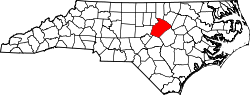
Location in Wake County and the state of North Carolina.
Coordinates: 35°41′34″N78°36′53″W / 35.69278°N 78.61472°W / 35.69278; -78.61472
CountryUnited States
State North Carolina
County Wake
Incorporated 1905
Government
  Type Council–Manager
  MayorBuddy Gupton [1]
Area
[2]
  Total18.32 sq mi (47.44 km2)
  Land18.27 sq mi (47.32 km2)
  Water0.05 sq mi (0.12 km2)
Elevation
[3]
325 ft (99 m)
Population
 (2020)
  Total31,159
  Density1,705.38/sq mi (658.44/km2)
Time zone UTC−5 (EST)
  Summer (DST) UTC−4 (EDT)
ZIP code
27529
Area code 919
FIPS code 37-25480 [4]
GNIS feature ID2406547 [3]
Website www.garnernc.gov

Garner is a town in Wake County, North Carolina, United States and a suburb of Raleigh. The population is 31,159 as of the 2020 census. The city limits are entirely within Wake County, though portions of unincorporated Wake County, as well as the Cleveland community in northern Johnston County, have Garner mailing addresses. It is part of the Research Triangle region of North Carolina and serves as a bedroom community for the region.

Contents

Geography

According to the United States Census Bureau, the town has a total area of 14.8 square miles (38.3 km2), of which 14.7 square miles (38.2 km2) is land and 0.04 square miles (0.1 km2), or 0.34%, is water. [5]

Garner is located entirely within Wake County. [6] There are unincorporated areas of Wake County and Johnston County that have Garner postal addresses, including a portion of the unincorporated, but densely populated, Cleveland Community.

Demographics

Historical population
CensusPop.Note
1910 284
1920 37632.4%
1930 47626.6%
1940 76861.3%
1950 1,18053.6%
1960 3,451192.5%
1970 4,92342.7%
1980 10,073104.6%
1990 14,96748.6%
2000 17,75718.6%
2010 25,74545.0%
2020 31,15921.0%
U.S. Decennial Census [7]

2020 census

Garner racial composition [8]
RaceNumberPercentage
White (non-Hispanic)15,90551.04%
Black or African American (non-Hispanic)9,16329.41%
Native American 1320.42%
Asian 6812.19%
Pacific Islander 170.05%
Other/Mixed 1,4684.71%
Hispanic or Latino 3,79312.17%

As of the 2020 United States census, there were 31,159 people, 11,642 households, and 7,637 families residing in the town.

2000 census

As of the census [4] of 2000, there were 17,757 people, 6,950 households, and 4,830 families residing in the town. The population density was 1,385.1 inhabitants per square mile (534.8/km2). There were 7,252 housing units at an average density of 565.7 per square mile (218.4/km2). The racial makeup of the town was 67.02% White, 27.13% African American, 0.41% Native American, 1.11% Asian, 0.02% Pacific Islander, 2.77% from other races, and 1.54% from two or more races. Hispanic or Latino of any race were 4.75% of the population.

There were 6,950 households, out of which 34.0% had children under the age of 18 living with them, 53.5% were married couples living together, 12.7% had a female householder with no husband present, and 30.5% were non-families. 24.2% of all households were made up of individuals, and 6.5% had someone living alone who was 65 years of age or older. The average household size was 2.51 and the average family size was 3.00.

In the town, the population was spread out, with 25.0% under the age of 18, 7.9% from 18 to 24, 33.6% from 25 to 44, 22.6% from 45 to 64, and 10.9% who were 65 years of age or older. The median age was 36 years. For every 100 females, there were 93.5 males. For every 100 females age 18 and over, there were 89.2 males.

The median income for a household in the town was $47,380, and the median income for a family was $58,302. Males had a median income of $37,359 versus $29,805 for females. The per capita income for the town was $22,433. About 4.9% of families and 6.8% of the population were below the poverty line, including 8.9% of those under age 18 and 10.1% of those age 65 or over.

History

Land near the town of Garner was first settled around 1751. In the 1850s, the North Carolina Railroad was built, and before the 1870s, a wood-and-water stop was established in present-day downtown Garner. The community of Garner's Station received a post office in 1878 and was incorporated in 1883, but the community had its charter repealed in 1891.

In 1905, the charter was reinstated as the Town of Garner. The first mayor was J.B. Richardson, and the first aldermen were H.D. Rand, J.J. Bagwell, H. Bryan, M.C. Penny, and J.S. Buffaloe.

In 1912, the telephone came to Garner. The town is off of US 70, which in 1917 became the first paved highway to be built in North Carolina. [9] An explosion and partial roof collapse of a ConAgra Foods plant on June 9, 2009, killed four and injured some 40 workers. [10] [11]

The Downtown Garner Historic District, Edenwood, and Meadowbrook Country Club are listed on the National Register of Historic Places. [12]

Government

City Council and City Manager

Garner currently operates under a council–manager government whereby the Town Council is the publicly elected legislative body of the town, and appoints a Town Manager to manage the administrative operations of the town. The Town Council consists of the Mayor and five Town Council Members, one of whom serves as Mayor "Pro Tempore." The composition of the Garner City Council, as of 2024, are as follows: [1]

Since March 2016, Rodney Dickerson has served as the Town Manager. [13]

City Police Department

As of 2019, the Garner Police Department has 68 sworn police officers and 10 professional staff personnel (including full-time and part-time staff) to provide law enforcement services to a town roughly 16 square miles in area with a permanent residential population of over 31,000 citizens. [14] The Department is divided into two bureaus—the Operations Bureau and the Administration Bureau.

Lorie Smith, a captain in the Garner Police Department since 2017, and interim chief since the October 1, 2022 retirement of Joe Binns, was officially promoted to the position of Garner police chief. Smith was formally sworn in on December 21, 2021.

Library

Garner's library service began in 1928 and was formed by the Garner's Women's Club, which operated and staffed the library with volunteer workers [15]

Today, Garner's public library is the Southeast Regional Library, which is a regional facility operated by Wake County Public Libraries. [16] The library offers Wake County Public Library's child and adult services, which include storytimes, adult craft programs, computer use, and other free activities for the community. [17] In 2020, as part of Wake County Public Library's Fine Free program, Southeast Regional Library has stopped collecting fines for books that are returned late. [18]

In June 2020, Southeast Regional Library began offering Wake County's Books on the Go program, a contactless book retrieval service that allows patrons to request and receive books from the library while it is closed due to COVID-19 [19]

Employment

According to Garner's 2020 Comprehensive Annual Financial Report, [20] the top employers in the town were:

#Employer# of Employees
1 Wake County Public School System 1,280
2 Pepsi Bottling Ventures 400
3 Walmart 350
4 Lowe's Home Improvement 335
5Sigma Electric Mfg Corp300
6 Target 290
7Hamlin Company250
8 Food Lion 220
9 Ameri Gas 198
10Town of Garner170

In 2020, Amazon began operations at a new Fulfillment Center in Garner and is expected to hire 3,000 full time employees. [21]

Transportation

Roads

Several major roads and highways serve Garner:

Public transportation

Garner is served by the GoRaleigh bus routes 7 and 40x, both serving the shopping centers around Garner Station. [22] [23] In October 2019, GoRaleigh bus route 20 replaced the rush-hour-only service of GoTriangle bus route 102 with all-day service. [24] Route 20 connects Downtown Garner with Downtown Raleigh as well as the shopping centers at White Oak, Timber Crossing, and Forest Hills, the Garner Town Hall, the Southeast Regional Library, and the Garner Police Station. [25]

Addition service is provided to seniors and those with disabilities through GoWake Access. This service provides door-to-door service to eligible residents that may have difficulties using traditional public transportation. [26]

Rail

Amtrak passes through Garner but does not have a scheduled stop; the nearest station is Raleigh Union Station.

Air

The nearest commercial airport with regular passenger service is Raleigh-Durham International Airport. General aviation services can also be found at the Triple W Airport in Fuquay-Varina or the Raleigh East Airport in Knightdale.

Education

The following schools serve students in and around Garner. Most, but not all, are located within the town limits of Garner. With few exceptions, school districts in North Carolina are organized at the county level, and students are often assigned to schools without regard to which municipality they live in.

Wake County public schools: [27]

Johnston County public schools: [28]

The original campus of the Governor Morehead School, a state-operated school for blind white students and blind and deaf black students, was in Garner. [29] In 1923 white blind students were moved to Raleigh. [30] The desegregation plan in the 1960s called for all deaf students to be moved to North Carolina School for the Deaf and Eastern North Carolina School for the Deaf, [29] while blind students were moved to Raleigh. [30]

Notable people

Related Research Articles

<span class="mw-page-title-main">Raleigh, North Carolina</span> Capital city of North Carolina, United States

Raleigh is the capital city of the U.S. state of North Carolina and the seat of Wake County. It is the second-most populous city in North Carolina, after Charlotte. Raleigh is the tenth-most populous city in the Southeast, the 41st-most populous city in the U.S., and the largest city of the Research Triangle metro area. Raleigh is known as the "City of Oaks" for its many oak trees, which line the streets in the heart of the city. The city covers a land area of 147.6 sq mi (382 km2). The U.S. Census Bureau counted the city's population as 467,665 in the 2020 census. It is one of the fastest-growing cities in the United States. The city of Raleigh is named after Sir Walter Raleigh, who established the now-lost Roanoke Colony in present-day Dare County.

<span class="mw-page-title-main">Wake County, North Carolina</span> County in North Carolina, United States

Wake County is located in the U.S. state of North Carolina. In the 2020 census, its population was 1,129,410, making it North Carolina's most populous county. From July 2005 to July 2006, Wake County was the 9th-fastest growing county in the United States, with Cary and Raleigh being the 8th- and 15th-fastest growing communities, respectively.

<span class="mw-page-title-main">Johnston County, North Carolina</span> County in North Carolina, United States

Johnston County is a county located in the U.S. state of North Carolina. As of the 2020 census, the population was 215,999. Its county seat is Smithfield.

<span class="mw-page-title-main">Franklin County, North Carolina</span> County in North Carolina, United States

Franklin County is a county located in the U.S. state of North Carolina. As of the 2020 census, the population was 68,573. Its county seat is Louisburg.

<span class="mw-page-title-main">Durham County, North Carolina</span> County in North Carolina, United States

Durham County is a county located in the U.S. state of North Carolina. As of the 2020 census, the population was 324,833, making it the sixth-most populous county in North Carolina. Its county seat is Durham, which is the only incorporated municipality predominantly in the county, though very small portions of cities and towns mostly in neighboring counties also extend into Durham County. The central and southern parts of Durham County are highly urban, consisting of the city as well as several unincorporated suburbs. Southeastern Durham County is dominated by the Research Triangle Park, most of which is in Durham County. The northern third of Durham County is rural in nature.

<span class="mw-page-title-main">Angier, North Carolina</span> Town in North Carolina, United States

Angier is a town in the Black River Township of Harnett County, North Carolina, United States. The population was 4,350 at the 2010 census and estimated as of 2018 to be 5,253. Angier is a part of the greater Raleigh–Durham–Cary Combined Statistical Area (CSA) as defined by the United States Census Bureau.

<span class="mw-page-title-main">Benson, North Carolina</span> Town in North Carolina, United States

Benson is a town in Johnston County, North Carolina, United States, near the intersection of Interstates 95 and 40. Benson celebrates Mule Days on the fourth Saturday of September, a festival that attracts over 60,000 people each year. In 2010, the population was 3,311, up from 2,923 in 2000.

<span class="mw-page-title-main">Clayton, North Carolina</span> Town in North Carolina, United States

Clayton is a town in Johnston County, North Carolina, United States, and is considered a satellite town of Raleigh. As of 2010, Clayton's population was 16,116, up from 6,973 at the 2000 census. By 2019 the town's estimated population was 24,887. Much of that growth can be attributed to the town's proximity to the Research Triangle area and access to major highways such as I-40 and US 70.

<span class="mw-page-title-main">Selma, North Carolina</span> Town in North Carolina, United States

Selma is a town in Johnston County, North Carolina, United States. In 2010, the population was 6,073, and as of 2018 the estimated population was 6,913. Selma is part of the Raleigh-Durham-Cary Combined Statistical Area. The area has a population over 1.7 million residents, though the town of Selma is able to maintain its rural character. The Everitt P. Stevens House, located in Selma, was the site of the last Grand Review of the Confederate Army held on April 6, 1865, after its defeat at the Battle of Bentonville.

<span class="mw-page-title-main">Smithfield, North Carolina</span> Town in North Carolina, United States

Smithfield is a town in and the county seat of Johnston County, North Carolina, United States. As of the 2010 census, its population was 10,966, and in 2019 the estimated population was 12,985. Smithfield is home to the Ava Gardner Museum and is situated along the Neuse River, where visitors enjoy the annual Smithfield Ham and Yam Festival, walks along the Buffalo Creek Greenway, and the historic downtown district. The town is located near North Carolina's Research Triangle and is about 30 miles (48 km) southeast of downtown Raleigh. The Raleigh-Durham-Cary combined statistical area has a population over 2 million residents.

<span class="mw-page-title-main">Apex, North Carolina</span> Town in North Carolina, United States

Apex is a town in Wake County, North Carolina, United States. At its southern border, Apex encompasses the community of Friendship. In 1994, the downtown area was designated a historic district, and the Apex train depot, built in 1867, is designated a Wake County landmark. The depot location marks the highest point on the old Chatham Railroad, hence the town's name. The town motto is "The Peak of Good Living".

<span class="mw-page-title-main">Fuquay-Varina, North Carolina</span> Town in North Carolina, United States

Fuquay-Varina is a town in southern Wake County, North Carolina, United States, lying south of Holly Springs and southwest of Garner, and north of the Harnett County town of Angier and west of the unincorporated community of Willow Springs. The population was 17,937 at the 2010 census, and estimated at 36,736 as of July 2021. The hyphenated name attests to the town's history as two separate towns. Fuquay Springs and Varina merged in 1963 to create the modern town. Economically, the town initially grew due to tobacco trade and agriculture, but has seen recent population growth and real estate development due to its proximity to Research Triangle Park.

<span class="mw-page-title-main">Holly Springs, North Carolina</span> Town in North Carolina, United States

Holly Springs is a town in Wake County, North Carolina, United States. As of the 2020 census, the town population was 41,239, a 67% increase from 2010.

<span class="mw-page-title-main">Knightdale, North Carolina</span> Town in North Carolina, United States

Knightdale is a town in Wake County, North Carolina, United States. As of the 2020 census, Knightdale has a population of 19,435. That's up from 11,401 in 2010. The U.S. Census Bureau estimates the town's population to be 17,843, as of July 1, 2019. Knightdale's population grew 10.4% from 2010 to 2013, making it the second fastest-growing community in the Research Triangle region for that time period.

<span class="mw-page-title-main">Wake Forest, North Carolina</span> Town in North Carolina, United States

Wake Forest is a town in Franklin, Granville and Wake counties in the U.S. state of North Carolina; located almost entirely in Wake County, it lies just north of the state capital, Raleigh. At the 2020 census, the population was 47,601. That is up from 30,117 in 2010, up from 12,588 in 2000. The U.S. Census Bureau estimates the city's population to be 47,601 as of April 1, 2020. In 2007, the town was listed by Forbes magazine as the 20th fastest growing suburb in America, with a 73.2 percent increase in population between 2000 and 2006. Wake Forest was the original home of Wake Forest University for 122 years before it moved to Winston-Salem in 1956.

<span class="mw-page-title-main">Goldsboro, North Carolina</span> City in North Carolina, United States

Goldsboro, originally Goldsborough, is a city in and the county seat of Wayne County, North Carolina, United States. The population was 33,657 at the 2020 census. It is the principal city of and is included in the Goldsboro, North Carolina Metropolitan Statistical Area. The nearby town of Waynesboro was founded in 1787, and Goldsboro was incorporated in 1847. It is the county seat of Wayne County.

<span class="mw-page-title-main">Morrisville, North Carolina</span> Town in North Carolina, United States

Morrisville is a town located primarily in Wake County, North Carolina, United States. According to the 2020 census, the population was 29,630. Morrisville is part of the Research Triangle metropolitan region. The regional name originated after the 1959 creation of the Research Triangle Park, located midway between the cities of Raleigh and Durham. The Research Triangle region encompasses the Raleigh-Durham-Cary, NC Combined Statistical Area. The population of the Raleigh-Durham-Cary, NC Combined Statistical Area was 2,106,463 in 2020, while the population of the Raleigh-Cary, NC Metropolitan Statistical Area was 1,413,982 in 2020. The operational headquarters of Lenovo is located in the municipal limits.

<span class="mw-page-title-main">Zebulon, North Carolina</span> Town in North Carolina, United States

Zebulon is the easternmost town in Wake County, North Carolina, United States. The population was 6,903 at the 2020 census. Zebulon is part of the Research Triangle metropolitan region. Five County Stadium, home to the Carolina Mudcats minor league baseball team, is located in the town. In May 2022, Zebulon was ranked North Carolina's second fastest growing town, only behind neighboring Wendell.

<span class="mw-page-title-main">Research Triangle</span> Geographic region of North Carolina, U.S.

The Research Triangle, or simply The Triangle, are both common nicknames for a metropolitan area in the Piedmont region of the U.S. state of North Carolina. Anchored by the cities of Raleigh and Durham and the town of Chapel Hill, the region is home to three major research universities: North Carolina State University, Duke University, and the University of North Carolina at Chapel Hill, respectively. The "Triangle" name originated in the 1950s with the creation of Research Triangle Park located between the three anchor cities, which is the largest research park in the United States and home to numerous high tech companies.

<span class="mw-page-title-main">Interstate 540 (North Carolina)</span> State highway and Interstate Highway in North Carolina, US

Interstate 540 (I-540) and North Carolina Highway 540 (NC 540) are part of a partially completed beltway around the city of Raleigh in the US state of North Carolina, forming the Raleigh Outer Loop. When complete, the route will completely encircle the city, meeting its parent route of I-40 in two locations.

References

  1. 1 2 "Mayor and Council Members | Town of Garner, NC". www.garnernc.gov. Retrieved January 20, 2024.
  2. "ArcGIS REST Services Directory". United States Census Bureau. Retrieved September 20, 2022.
  3. 1 2 U.S. Geological Survey Geographic Names Information System: Garner, North Carolina
  4. 1 2 "U.S. Census website". United States Census Bureau . Retrieved January 31, 2008.
  5. "Geographic Identifiers: 2010 Demographic Profile Data (G001): Garner town, North Carolina". United States Census Bureau . Retrieved December 29, 2011.
  6. "Garner Corporate Limits as of August, 2008" (PDF). Archived from the original (PDF) on January 28, 2016. Retrieved December 24, 2019.
  7. "Census of Population and Housing". Census.gov. Retrieved June 4, 2015.
  8. "Explore Census Data". data.census.gov. Retrieved December 20, 2021.
  9. Town of Garner website, Town History
  10. "Bodies removed from Garner plant rubble". wral.com. June 10, 2009. Archived from the original on June 14, 2011. Retrieved June 10, 2009.
  11. "2 dead, 1 missing after Slim Jim plant explosion". cnn.com. June 9, 2009. Archived from the original on May 29, 2010. Retrieved June 10, 2009.
  12. "National Register Information System". National Register of Historic Places . National Park Service. July 9, 2010.
  13. "Town Manager | Town of Garner, NC". www.garnernc.gov. Retrieved February 20, 2021.
  14. "Garner Police Department 2019 Annual Report". 2019. Retrieved February 19, 2021.
  15. "A Brief Town History | Town of Garner, NC".
  16. "Southeast Regional Library".
  17. "At Your Service".
  18. "I heard the library is "late fee free." What does this mean? - AskWCPL".
  19. "WCPL Books on the Go".
  20. "Town of Garner Comprehensive Annual Financial Report". Town of Garner. December 18, 2020. Retrieved February 19, 2021.
  21. "Amazon hiring 3,000 workers for new Garner facility". www.msn.com. Retrieved February 20, 2021.
  22. "Maps & Schedules | GoRaleigh". goraleigh.org. Retrieved February 20, 2021.
  23. "Maps & Schedules | GoRaleigh". goraleigh.org. Retrieved February 20, 2021.
  24. "All-day GoRaleigh service for Knightdale, Garner replaces peak-hours-only GoTriangle routes Oct. 14 | GoTriangle". gotriangle.org. Retrieved February 20, 2021.
  25. "Maps & Schedules | GoRaleigh". goraleigh.org. Retrieved February 20, 2021.
  26. "GoWake Access Transportation". Wake County Government. Retrieved February 20, 2021.
  27. Wake County Public School System
  28. Schools in Johnston County Schools. Schooldigger.com Archived March 10, 2012, at the Wayback Machine
  29. 1 2 "$89,927 Blind-Deaf School May Lose U.S. Aid". The Charlotte Observer . Associated Press. September 15, 1966. p. 18A. - Clipping at Newspapers.com.
  30. 1 2 "About GMS". Governor Morehead School. Retrieved June 26, 2021.
  31. Nyheim Hines Stats. Pro-Football-Reference. Retrieved July 16, 2020.
  32. James Mays, Clemson, Power Forward - 247Sports.com. Retrieved July 16, 2020.
  33. #2 Manny Perez. northcarolinafc.com. Retrieved July 16, 2020.
  34. Cooper, Duncan. (May 4, 2017). Meet Sarah Shook, Country Music’s Radical And Ordinary Hero. The Fader. Retrieved July 16, 2020.
  35. Pat Watkins Stats. Baseball-Reference. Retrieved July 16, 2020.