
Durham County is a county located in the U.S. state of North Carolina. As of the 2010 census, the population was 267,587, making it the sixth-most populous county in North Carolina. Its county seat is Durham.

Bartons Creek Township is one of twenty townships within Wake County, North Carolina. As of the 2010 census, Bartons Creek Township had a population of 22,055.

Leesville Township is one of twenty townships within Wake County, North Carolina. As of the 2010 census, Leesville Township had a population of 41,850, a 39.5% increase over 2000.

Cedar Fork Township is one of twenty townships within Wake County, North Carolina. As of the 2010 census, Cedar Fork Township had a population of 40,841, a 274.3% increase over 2000.

Neills Creek Township is one of thirteen townships in Harnett County, North Carolina, United States. The township had a population of 5,921 according to the 2000 census. It is a part of the Dunn Micropolitan Area, which is also a part of the greater Raleigh–Durham–Cary Combined Statistical Area (CSA) as defined by the United States Census Bureau.

Lillington Township is one of thirteen townships in Harnett County, North Carolina, United States. The township had a population of 4,573 according to the 2000 census. It is a part of the Dunn Micropolitan Area, which is also a part of the greater Raleigh–Durham–Cary Combined Statistical Area (CSA) as defined by the United States Census Bureau.

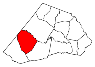
Black River Township is one of thirteen townships in Harnett County, North Carolina, United States. The township had a population of 8,085 according to the 2000 census. It is a part of the Dunn Micropolitan Area, which is also a part of the greater Raleigh–Durham–Cary Combined Statistical Area (CSA) as defined by the United States Census Bureau.

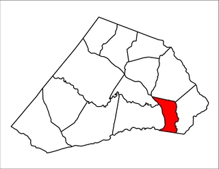
Averasboro Township is one of thirteen townships in Harnett County, North Carolina, United States. The township had a population of 12,965 according to the 2000 census and is the largest township in Harnett County by population. It is a part of the Dunn Micropolitan Area, which is also a part of the greater Raleigh–Durham–Cary Combined Statistical Area (CSA) as defined by the United States Census Bureau.
Duke Township is one of thirteen townships in Harnett County, North Carolina, United States. The township had a population of 5,965 according to the 2000 census and is the largest township in Harnett County by population. It is a part of the Dunn Micropolitan Area, which is also a part of the greater Raleigh–Durham–Cary Combined Statistical Area (CSA) as defined by the United States Census Bureau.
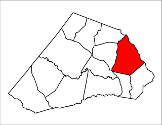
Grove Township is one of thirteen townships in Harnett County, North Carolina, United States. The township had a population of 9,475 according to the 2000 census. It is a part of the Dunn Micropolitan Area, which is also a part of the greater Raleigh–Durham–Cary Combined Statistical Area (CSA) as defined by the United States Census Bureau.

Stewarts Creek Township is one of thirteen townships in Harnett County, North Carolina, United States. The township had a population of 3,482 according to the 2000 census. It is a part of the Dunn Micropolitan Area, which is also a part of the greater Raleigh–Durham–Cary Combined Statistical Area (CSA) as defined by the United States Census Bureau.

Johnsonville Township is one of thirteen townships in Harnett County, North Carolina, United States. The township had a population of 6,927 according to the 2000 census. It is a part of the Dunn Micropolitan Area, which is also a part of the greater Raleigh–Durham–Cary Combined Statistical Area (CSA) as defined by the United States Census Bureau.
Barbecue Township is one of thirteen townships in Harnett County, North Carolina, United States. In the 2010 census, it had a population of 17,033 in 6,330 households. It is a part of the Dunn Micropolitan Area, which is also a part of the greater Raleigh–Durham–Cary Combined Statistical Area (CSA) as defined by the United States Census Bureau.
Buckhorn Township is one of thirteen townships in Harnett County, North Carolina, United States. The township had a population of 1,905 according to the 2000 census. It is a part of the Dunn Micropolitan Area, which is also a part of the greater Raleigh–Durham–Cary Combined Statistical Area (CSA) as defined by the United States Census Bureau.

Hectors Creek Township is one of thirteen townships in Harnett County, North Carolina, United States. The township had a population of 3,629 according to the 2000 census. It is a part of the Dunn Micropolitan Area, which is also a part of the greater Raleigh–Durham–Cary Combined Statistical Area (CSA) as defined by the United States Census Bureau.

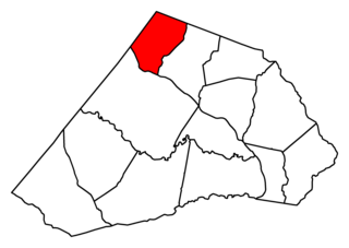
Upper Little River Township is one of thirteen townships in Harnett County, North Carolina, United States. The township had a population of 7,708 according to the 2000 census. It is a part of the Dunn Micropolitan Area, which is also a part of the greater Raleigh–Durham–Cary Combined Statistical Area (CSA) as defined by the United States Census Bureau.

Durham Township is one of six townships in Durham County, North Carolina, United States. The township had a population of 103,863 according to the 2000 census and is currently the most populous township in Durham County.

Mangum Township is one of six townships in Durham County, North Carolina, United States. The township had a population of 5,821 according to the 2000 census.

Triangle Township is one of six townships in Durham County, North Carolina, United States. The township had a population of 67,870 according to the 2000 census.

Lebanon Township is one of six townships in Durham County, North Carolina, United States. The township had a population of 16,415 according to the 2000 census.

