Asheboro, North Carolina | |
|---|---|
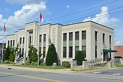 Asheboro municipal building | |
 Seal | |
| Nickname: Zoo City | |
| Motto: "Exactly where you want to be." | |
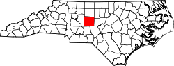
 Location of Asheboro, North Carolina | |
 Asheboro  Asheboro  Asheboro | |
| Coordinates: 35°42′57″N79°48′46″W / 35.71583°N 79.81278°W | |
| Country | United States |
| State | North Carolina |
| County | Randolph |
| Incorporated | December 25, 1796 |
| Named after | Samuel Ashe |
| Government | |
| • Type | Council-manager |
| • Body | Asheboro City Council |
| • Mayor | Joey Trogdon |
| • City Manager | Donald Duncan Jr. |
| Area | |
• Total | 19.00 sq mi (49.20 km2) |
| • Land | 18.90 sq mi (48.95 km2) |
| • Water | 0.093 sq mi (0.24 km2) |
| Elevation | 846 ft (258 m) |
| Population (2020) | |
• Total | 27,156 |
| • Density | 1,436.7/sq mi (554.73/km2) |
| Time zone | UTC−5 (Eastern (EST)) |
| • Summer (DST) | UTC−4 (EDT) |
| ZIP codes | 27203-27205 |
| Area code | 336-743 |
| FIPS code | 37-02080 [3] |
| GNIS feature ID | 2403119 [2] |
| Website | www |
Asheboro is a city in and the county seat of Randolph County, North Carolina, United States. [4] The population was 27,156 at the 2020 census. It is part of the Greensboro-High Point Metropolitan Area of the Piedmont Triad and is home of the state-owned North Carolina Zoo. [5]