Randolph County is a county located in the U.S. state of North Carolina. As of the 2020 census, the population was 144,171. Its county seat is Asheboro.

Kenansville is a town in Duplin County, North Carolina, United States. Its population was 855 at the 2010 census. It is the county seat of Duplin County. The town was named for James Kenan, a member of the North Carolina Senate, whose family home Liberty Hall Plantation is in Kenansville.

Warsaw is a town in Duplin County, North Carolina, United States. The population was 3,054 at the 2010 census.

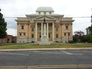
Columbus is a town in Polk County, North Carolina, United States. The population was 999 at the 2010 census. It is the county seat of Polk County.
Orrum is a town in Robeson County, North Carolina, United States. The population was 91 at the 2010 census.
Eureka is a town in Wayne County, North Carolina, United States. The population was 197 at the 2010 census. It is included in the Goldsboro, North Carolina Metropolitan Statistical Area.

Inman is a city in Spartanburg County, South Carolina, United States. The population was 3,665 at the 2020 census, and 2,321 at the 2010 census.
Haywood is an unincorporated community in southeastern Chatham County, North Carolina, United States. It is part of the Moncure census-designated place. Along with several other unincorporated communities, it lies along the panhandle of Chatham County between Lee County and Wake County. Haywood lies at an elevation of 246 feet (75 m).
Jason is a small unincorporated community in eastern North Carolina, United States, in Greene County. Incorporated in 1885, Jason is an agricultural based community with town water system and volunteer fire service. Jason is located roughly halfway between Snow Hill and LaGrange on Highway 903. First named Aloc, meaning "leave alone" by the Tuscarora Indian tribe, Jason was settled by the Hardy, Mewborn, Aldridge and Kearney families. Once a prospering town with a furniture store, post office, and general store, one could buy groceries, post a letter, purchase alcohol, and be placed in jail, all in the same building. There was also a cotton mill on the northern side of town, which was one of the first in Greene County.
Gold Hill is an unincorporated community and census-designated place (CDP) in southeastern Rowan County, North Carolina, United States near the Cabarrus County line. It was first listed as a CDP in the 2020 census with a population of 372. It is situated near the Yadkin River and is served by U.S. Highway 52 and Old Beatty Ford Road. Gold was found in this small town outside Salisbury in the 19th century.

Bonlee is an unincorporated community in western Chatham County, North Carolina, United States. It is located south of Siler City and north of Bear Creek along Old U.S. Route 421. Bonlee sits at an elevation of 518 feet (158 m). The community is home to several poultry feed mills and a K-8 school. The ZIP Code for Bonlee is 27213.
Oak Grove is an unincorporated community in northern Surry County, North Carolina, United States, located near Bottom.
Riley Hill, North Carolina, United States, is an unincorporated community in mideastern Wake County. It is at the southern end of Broughton Road, on Riley Hill Road and is approximately six miles northeast of Knightdale, and approximately 3.8 miles north of the intersection of U.S. 64/264, and Business U.S. 64.
Farrington is an unincorporated community in Chatham County, North Carolina, United States. It is now part of the Fearrington Village census-designated place.
Bells is an unincorporated community in Chatham County, North Carolina, United States, located south of Farrington. It lies at an elevation of 226 feet.

Cumnock, formerly known as Egypt, is an unincorporated community in northwestern Lee County, North Carolina, United States. It lies on Cumnock Road, about a mile north of U.S. Route 421.
Crutchfield Crossroads is an unincorporated community in northwestern Chatham County, North Carolina, United States, north of the town of Siler City. Crutchfield Crossroads is commonly defined as the area in and around the rural intersection of Silk Hope-Liberty Road. and Siler City- Snow Camp Road. At the intersection of the two roads, there are some stores, but other than that the entire community is agricultural. Children living in this area attend schools in Silk Hope and Siler City.
Randolph Community College is a public community college in Randolph County, North Carolina. It is part of the North Carolina Community College System.

Coleridge Historic District is a national historic district located at Coleridge, Randolph County, North Carolina. The district encompasses 17 contributing buildings in the Victorian mill village of Coleridge. It includes buildings built between 1882 and the late 1920s and notable examples of Queen Anne and Romanesque Revival architecture. Notable buildings include the Enterprise Cotton Mill complex, the company store, mill office, Bank of Coleridge, and John Caveness House.

