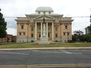
Randolph County is a county located in the U.S. state of North Carolina. As of the 2020 census, the population was 144,171. Its county seat is Asheboro.
Moore County is a county located in the U.S. state of North Carolina. As of the 2020 census, its population was 99,727. Its county seat is Carthage and its largest community Pinehurst. It is a border county between the Piedmont and the Atlantic Coastal Plain.

Guilford County is a county located in the U.S. state of North Carolina. As of the 2020 census, the population was 541,299, making it the third-most populous county in North Carolina. The county seat and largest community is Greensboro. Since 1938, an additional county court has been located in High Point. The county was formed in 1771. Guilford County is included in the Greensboro-High Point, NC Metropolitan Statistical Area, which is also included in the Greensboro–Winston-Salem–High Point, NC Combined Statistical Area.

Forsyth County is a county located in the northwest Piedmont of the U.S. state of North Carolina. As of the 2020 census, the population was 382,590, making it the fourth-most populous county in North Carolina. Its county seat is Winston-Salem. Forsyth County is part of the Winston-Salem, NC, Metropolitan Statistical Area, which is also included in the Greensboro–Winston-Salem–High Point, NC, Combined Statistical Area. Portions of Forsyth County are in the Yadkin Valley wine region.

Durham County is a county located in the U.S. state of North Carolina. As of the 2020 census, the population was 324,833, making it the sixth-most populous county in North Carolina. Its county seat is Durham, which is the only incorporated municipality predominantly in the county, though very small portions of cities and towns mostly in neighboring counties also extend into Durham County. The central and southern parts of Durham County are highly urban, consisting of the city as well as several unincorporated suburbs. Southeastern Durham County is dominated by the Research Triangle Park, most of which is in Durham County. The northern third of Durham County is rural in nature. Durham County is the core of the Durham-Chapel Hill, NC Metropolitan Statistical Area, which is also included in the Raleigh-Durham-Cary, NC Combined Statistical Area, which had an estimated population of 2,368,947 in 2023.

Cumberland County is a county located in the U.S. state of North Carolina. As of the 2020 census, the population was 334,728, making it the fifth-most populous county in North Carolina. Its county seat is Fayetteville. Cumberland County is part of the Fayetteville, NC Metropolitan Statistical Area.
Buncombe County is a county located in the U.S. state of North Carolina. It is classified within Western North Carolina. The 2020 census reported the population was 269,452, making it the 7th-most populous county in North Carolina. Its county seat is Asheville. Buncombe County is part of the Asheville, NC Metropolitan Statistical Area.

Asheboro is a city in and the county seat of Randolph County, North Carolina, United States. The population was 27,156 at the 2020 census. It is part of the Greensboro-High Point Metropolitan Area of the Piedmont Triad and is home of the state-owned North Carolina Zoo.

Randleman is a city in Randolph County, North Carolina, United States. The population was 4,113 at the 2010 census. It is the home of NASCAR's Petty family, the Victory Junction Gang Camp and was the location of the Richard Petty Museum from 2003 to 2014.

Seagrove is a town in Randolph County, North Carolina, United States. The population was 285 at the 2019 census. It was named after a railroad official when the area was connected by rail. In 2020, the center of population of North Carolina was located east of Seagrove.

The Yadkin River is one of the longest rivers in the US state of North Carolina, flowing 215 miles (346 km). It rises in the northwestern portion of the state near the Blue Ridge Parkway's Thunder Hill Overlook. Several parts of the river are impounded by dams for water, power, and flood control. The river becomes the Pee Dee River at the confluence of the Uwharrie River south of the community of Badin and east of the town of Albemarle. The river then flows into South Carolina near Cheraw, which is at the Fall Line. The entirety of the Yadkin River and the Great Pee Dee River is part of the Yadkin-Pee Dee River Basin.

The Catawba River is a major river located in the Southeastern United States. It originates in Western North Carolina and flows into South Carolina, where it later becomes known as the Wateree River. The river is approximately 220 miles (350 km) long. It rises in the Appalachian Mountains and drains into the Piedmont, where it has been impounded through a series of reservoirs for flood control and generation of hydroelectricity. The river is named after the Catawba tribe of Native Americans, which lives on its banks. In their language, they call themselves "yeh is-WAH h’reh", meaning "people of the river."
Glenville is an unincorporated community and census-designated place (CDP) in Jackson County, North Carolina, United States. It is now a popular lakeside vacation community with many second homes that sometimes are rented around Lake Glenville, which flooded and destroyed the original town. As of the 2010 census, the year-round population was 110.

North Carolina Highway 705 (NC 705) is a primary state highway in the U.S. state of North Carolina. The route is marked as the Pottery Highway or Pottery Road and as a North Carolina Scenic Byway due to the large number of potters in and surrounding Seagrove.

U.S. Route 220 is a north–south U.S. highway which travels from Rockingham, North Carolina, to South Waverly, Pennsylvania. In the U.S. state of North Carolina, US 220 travels 123.4 miles (198.6 km) from an intersection with US 1 in Rockingham to the Virginia state line near Price, North Carolina. The highway is an important north–south route in Central North Carolina, connecting Rockingham, Asheboro, Greensboro, and Summerfield. US 220 runs concurrently with Interstate 73 from north of Rockingham to Greensboro, and from Summerfield to Stokesdale; while US 220 runs concurrently with I-74 from Rockingham to Randleman.
Level Cross is an unincorporated community in Randolph County, North Carolina. It is located at the intersection of U.S. Route 220 with Branson Mill Road. Level Cross is located a few miles north of Randleman.
Okeewemee is an unincorporated community that is located in Montgomery County, North Carolina, United States.
Black Ankle is an unincorporated community in the northeastern part of Montgomery County, North Carolina, United States.

Whynot is an unincorporated community in Randolph County, North Carolina, United States, and is included in the Piedmont Triad metropolitan region. Whynot is located on NC 705, also known as the "North Carolina Pottery Highway", one mile (1.6 km) southeast of Seagrove and seven miles (11 km) west of Jugtown Pottery, a historic pottery listed on the National Register of Historic Places. The North Carolina Pottery Highway contains over 100 potteries and galleries in a 15-square-mile (39 km2) region surrounding Seagrove.

North Carolina Highway 13 (NC 13) was a primary state highway in the U.S. state of North Carolina. The highway connected U.S. Route 220 (US 220) north of Seagrove with US 421 in Staley. The routing of the highway was fairly rural, with Staley the only notable town along the routing. The route was established in 1936 and decommissioned in 1951.

