
Seagrove is a town in Randolph County, North Carolina, United States. The population was 285 at the 2019 census. It was named after a railroad official when the area was connected by rail. The center of population of North Carolina is located a few miles east of Seagrove.
U.S. Route 264 (US 264) is an east–west United States highway that runs for 215.7 miles (347.1 km) from Raleigh to Manns Harbor, completely in the state of North Carolina. From its western terminus to Greenville it is a freeway, bypassing Wilson to the south and passing through or near several small towns such as Knightdale, Wendell, Zebulon, Middlesex, Bailey, Saratoga, and Farmville. It continues as a divided highway with at-grade intersections from Greenville east to Washington, where it passes through town along 5th Street. East of Washington it is an undivided road passing through the marshes along the Pamlico River and Pamlico Sound, going along the south shore of Lake Mattamuskeet and meeting its eastern terminus with US 64 near Manns Harbor. The route has significant concurrencies with US 64, I-87 and I-795. The route from Zebulon to Greenville has been designated as Future Interstate 587, pending upgrades to the freeway to Interstate Highway standards. The freeway section is paralleled by Alternate 264, and a business loop is designated in Belhaven.
North Carolina Highway 24 (NC 24) is the longest primary state highway in the U.S. state of North Carolina. Traveling east–west between the Charlotte metropolitan area and the Crystal Coast, connecting the cities of Charlotte, Fayetteville, Jacksonville and Morehead City.

North Carolina Highway 226 (NC 226) is a primary state highway in the U.S. state of North Carolina. Traveling north–south through Western North Carolina, it connects the cities and towns of Grover, Shelby, Marion, Spruce Pine and Bakersville. It also a scenic byway in the South Mountains area and connects with the summer colony of Little Switzerland, via NC 226A.
North Carolina Highway 49 (NC 49) is a primary state highway in the U.S. state of North Carolina. It traverses much of the Piedmont region of North Carolina.

North Carolina Highway 20 is a 27-mile (43 km) North Carolina state highway that runs through Hoke, Robeson and Bladen counties. It serves as a major road in each of the three incorporated communities through which it passes. The route is co-designated as St. Pauls Road in Raeford, Main Street in Lumber Bridge, and Broad Street in St. Pauls.

North Carolina Highway 22 is a North Carolina state highway that runs in the central-north part of the state. It runs between Southern Pines and Climax. The route is signed north–south, and is 59 miles (95 km) in length.

North Carolina Highway 87 (NC 87) is a primary state highway in the U.S. state of North Carolina. NC 87 begins in the Atlantic coastal town of Southport and crosses into Virginia at the Virginia state line five miles (8 km) north of Eden in Rockingham County. At 240 miles (390 km) in length, NC 87 is the second longest state highway in the U.S. state of North Carolina with only North Carolina Highway 24 being longer. Labeled as a north–south route, NC 87 travels along a relatively straight southeast–northwest path, connecting Cape Fear region with the Piedmont. It is also the main north-south route connecting the cities of Fayetteville, Sanford, Burlington and Reidsville.

North Carolina Highway 28 (NC 28) is an 81.2-mile-long (130.7 km) primary state highway in the U.S. state of North Carolina. The highway runs north–south through the Nantahala National Forest in Western North Carolina.

The Fayetteville and Western Plank Road was a 129 mi (208 km) plank road from Fayetteville, NC to the Moravian settlement at Bethania, NC. The road was constructed from 1851-1852 using funds raised by boosters and accompanying funds provided by the state of North Carolina.

North Carolina Highway 73 (NC 73) is a primary state highway in the U.S. state of North Carolina that travels through south-central North Carolina in the United States. Most of the route is a two-lane highway that passes through both rural scenic areas; however, it also serves several small and moderate-sized cities in the state, including Concord and Albemarle. The western terminus of NC 73 is at an intersection with NC 27 east of Lincolnton and its eastern terminus is at a junction with US 15/US 501 in Eastwood.

North Carolina Highway 242 (NC 242) is a primary state highway in the U.S. state of North Carolina. It traverses from Cerro Gordo to Benson, connecting the cities of Bladenboro, Elizabethtown, and Roseboro.
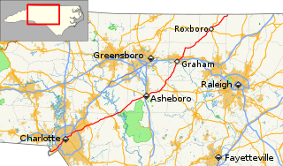
U.S. Route 220 is a north–south U.S. highway which travels from Rockingham, North Carolina to South Waverly, Pennsylvania. In the U.S. state of North Carolina, US 220 travels 123.4 miles (198.6 km) from an intersection with US 1 in Rockingham to the Virginia state line near Price, North Carolina. The highway is an important north-south route in Central North Carolina, connecting Rockingham, Asheboro, Greensboro, and Summerfield. US 220 runs concurrently with Interstate 73 from north of Rockingham to Greensboro, and from Summerfield to Stokesdale; while US 220 runs concurrently with I-74 from Rockingham to Randleman.
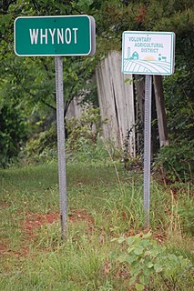
Whynot is an unincorporated community in Randolph County, North Carolina, United States, and is included in the Piedmont Triad metropolitan region. Whynot is located on NC 705, also known as the "North Carolina Pottery Highway", one mile (1.6 km) southeast of Seagrove and seven miles (11 km) west of Jugtown Pottery, a historic pottery listed on the National Register of Historic Places. The North Carolina Pottery Highway contains over 100 potteries and galleries in a 15-square-mile (39 km2) region surrounding Seagrove.

North Carolina Highway 59 (NC 59) is an 8.288-mile-long (13.338 km) primary state highway in the U.S. state of North Carolina that runs through Cumberland County from Interstate 95 (I-95) near Hope Mills to U.S. Route 401 Business in Owens, within the city limits of Fayetteville.
North Carolina Highway 210 is a 192-mile-long (309 km) primary state highway in the U.S. state of North Carolina that connects settlements in the Atlantic Coastal Plain region. Due to its meandering route NC 210 changes directional orientation twice, changing from east-west to north-south at Old Stage Road east of Angier, then changing from north-south to west-east at the Bladen–Pender county line. The route traverses through central Fayetteville and the Fort Bragg Army installation and crosses both Topsail Island access bridges over the Atlantic Intracoastal Waterway. Owing primarily to its meandering route, NC 210 is the sixth longest state highway in North Carolina.

North Carolina Highway 209 (NC 209) is a primary state highway in the U.S. state of North Carolina. The highway runs north–south from Lake Junaluska to Hot Springs.

Jugtown Pottery was founded in 1921 by Jacques and Juliana Busbee, artists from Raleigh, North Carolina, who in 1917 discovered an orange pie dish and traced it back to Moore County. There, they found a local tradition of utilitarian pottery in orange, earthenware, and salt glazes. The Busbees saw an opportunity to help save a dying craft, and in 1918 they set up the village store in Greenwich Village, New York, in order to sell the pottery. Potters they worked with over the years included J. H. Owen, Charlie Teague, and Ben Owen.

North Carolina Highway 225 (NC 225) is a 10.7-mile (17.2 km) route running from U.S. Route 25 (US 25), near the South Carolina state line to Hendersonville. It crosses over US 25 once before ending. It runs through East Flat Rock and near Lake Summit. The route is a prior alignment of US 25, designated after a new freeway was opened in stages from 1981–2003.
North Carolina Highway 13 (NC 13) was a primary state highway in the U.S. state of North Carolina. The highway connected U.S. Route 220 (US 220) north of Seagrove with US 421 in Staley. The routing of the highway was fairly rural, with Staley the only notable town along the routing. The route was established in 1936 and decommissioned in 1951.


