Pittsboro, North Carolina

Last updated

Pittsboro, North Carolina
Town
Hillsboro Street.jpg
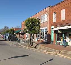
Hillsboro Street in downtown Pittsboro
Pittsboro, NC Town Seal.png
Nickname: 
Circle City
NCMap-doton-Pittsboro.PNG
Location of Pittsboro, North Carolina
Coordinates: 35°43′40″N79°10′10″W / 35.72778°N 79.16944°W / 35.72778; -79.16944
CountryUnited States
State North Carolina
County Chatham
Government
  MayorCindy Perry
Area
[1]
  Total5.52 sq mi (14.29 km2)
  Land5.49 sq mi (14.21 km2)
  Water0.03 sq mi (0.08 km2)
Elevation
[2]
466 ft (142 m)
Population
 (2020)
  Total4,537
  Density826.86/sq mi (319.24/km2)
Time zone UTC-5 (Eastern (EST))
  Summer (DST) UTC-4 (EDT)
ZIP codes
27228, 27312
Area code 919 / 984
FIPS code 37-52660 [3]
GNIS feature ID2407130 [2]
Website pittsboronc.gov

Pittsboro is a town in Chatham County, North Carolina, United States. The population was 3,743 at the 2010 census [4] and 4,537 at the 2020 census. It is the county seat of Chatham County. [5]

Contents

The town was established in the late 18th century, shortly after the American Revolution, as the county seat for the newly formed Chatham County. In the years leading up to the American Civil War, the economy was dominated by small-scale farms that relied heavily on enslaved labor, and in the aftermath of the civil war, racial tensions were high, and the town was noted for a number of lynchings and other racial violence in the late 19th century. Industrialization came to the community in the late 19th century, as a number of rivers cross the area providing locations for mills and factories. Economic and population growth would continue into and throughout the 20th century. As industry moved away from the community, it has in the 21st century transitioned into a bedroom community for the nearby cities of the Research Triangle region.

History

Foundation and early years

Pittsboro was established as a town in 1785. [6] The Chatham County Court House was built on land belonging to Mial Scurlock, but in 1787 the legislature declared that a town could not be established on Scurlock's land. The town's trustees instead purchased adjacent land belonging to William Petty and laid out the town. [7] That same year, Pittsboro was officially named the county seat. Although Chatham County is named for William Pitt, 1st Earl of Chatham, Pittsboro is named for his son, William Pitt the Younger.

Pittsboro was once considered as a site for both the University of North Carolina and the state capital. The university was established in Chapel Hill, beginning in 1789. The state capital is Raleigh, 34 miles (55 km) east of Pittsboro.

As the county seat, Pittsboro has been a center of trade and local government, including the courts. Many farmers would come into town on the weekend for trade. In 1881 a new county courthouse and jail were built in Pittsboro.

Slavery and racial segregation

The area did not have large plantations, but farmers also depended on slave labor. In 1860 nearly one-third of the county population was made up of enslaved African Americans. After the Civil War and emancipation, whites used violence and other means to enforce white supremacy and suppress the freedmen's vote. The Ku Klux Klan and other supremacist groups were active in the county. [8]

Pittsboro was the scene of a notorious mass lynching of four African Americans in 1885, including a woman. The event earned statewide condemnation. Those lynched were tenant farmers. A masked mob took Jerry Finch, his wife Harriet, and Lee Tyson from jail, where they were being held after arrest as suspects in a robbery/murder case. [8] Harriet Finch was one of four black women to be lynched in the state. [9] They also took and hanged John Pattishall, who was awaiting trial for two other unrelated robbery/murders. [10]

A white mob broke into the Pittsboro jail and seized a 16-year-old boy, Eugene Daniel. He was lynched and then had his body riddled with bullets on September 18, 1921. [11] [12]

Violence continued during the stress of economic hard times at the end of the century and into the early 20th century, when the state disenfranchised most blacks. This political exclusion lasted until after 1965 and passage of the Voting Rights Act. In 2019, a statue erected in 1907 of a Confederate soldier outside the Chatham County Courthouse in Pittsboro was taken down. [13] [14]

Early industrialization

Textile mills in the north-central area of the county along the Haw River, Rocky River, and Deep River provided new manufacturing jobs to workers who had lost farm holdings due to economic depressions of the 1870s and early 1880s. It was the beginning of industrialization around Pittsboro.

Chatham County Courthouse fire

Chatham County Courthouse Chatham County Courthouse, Pittsboro, North Carolina.jpg
Chatham County Courthouse

On March 25, 2010, the Chatham County Courthouse, while undergoing a $415,000 exterior renovation, caught fire. Smoke was first reported in the area around 4:15 pm; the fire was dispatched to the Pittsboro Fire Department around 4:45 pm. By 5 pm, smoke was reported to be rising from out of the clock tower, which was surrounded by scaffolds. The building was evacuated safely.

The building suffered severe damage to the clock tower and the third floor. It was reported that the fire had destroyed all the computers and records, but there were offsite copies and the information was recoverable. [15]

On March 26, 2010, at approximately 1:30 am, the clock tower collapsed onto the main building, but the building as a whole was damaged only on the second floor. Damage in the rest of the building was from water and smoke effects. Overall 11 fire departments participated in the fire efforts.

The fire marshal's investigation into the fire determined that it was caused by a soldering torch that ignited wood near the soffit. Workers attempted to extinguish the blaze, but were unsuccessful. On March 31, 2010, the Chatham County Commissioners voted to rebuild the courthouse. [16] It reopened on April 20, 2013. [17]

City government

The mayor of Pittsboro is elected at-large. The current mayor is Cindy Perry. The town's five members of the Board of Commissioners are also elected at-large. They are Pamela Baldwin, J.A. (Jay) Farrell, Kyle Shipp, John Bonitz, and James Vose. The Board of Commissioners hires a town manager to administer daily operations of the city; the current town manager is Chris Kennedy. [18] Manager Morgan assumed office after former Manager Bryan Gruesbeck resigned at the request of the Board in January 2020. [19]

Pittsboro holds elections for the Mayor and three seats on the Board of Commissioners every four years in the off-year after each midterm election. Two Pittsboro Commissioners are elected in the off-year after each presidential election. [18]

Pittsboro Police is directed by Chief Shorty Johnson. Serving Pittsboro's 4,000 residents, the department comprises 8 patrolmen, 1 community police officer, 1 lead investigator and 1 lieutenant. [20]

Educational facilities

The town is served by five local schools and a Central Carolina Community College campus:

Media outlets

Newspapers
Network television

Geography

Pittsboro is located east of the center of Chatham County. U.S. Highways 15 and 501 run concurrently through the center of the town as Hillsboro Street and Sanford Road, leading north 17 miles (27 km) to the center of Chapel Hill and the University of North Carolina, and south 17 miles (27 km) to Sanford. U.S. Route 64 bypasses Pittsboro to the north and leads east 34 miles (55 km) to Raleigh and west 16 miles (26 km) to Siler City. U.S. Route 64 Business passes through the town as West Street and East Street, crossing US 15/501 at the traffic circle that surrounds the historic Chatham County Courthouse in the center of town. North Carolina Highway 87 leads northwest from Pittsboro 32 miles (51 km) to Burlington.

Near the geographic center of the state, Pittsboro is 150 miles (240 km) from Wilmington at the coast and the same distance from Boone in the Blue Ridge Mountains.

Jordan Lake is 8 miles (13 km) east, providing recreation, fishing, boating and scenic panoramas. The lake is 14,000 acres (5,700 ha) of surface and provides water for Raleigh and the towns of Cary and Apex.

According to the United States Census Bureau, the town has a total area of 4.2 square miles (10.8 km2), of which 4.1 square miles (10.7 km2) is land and 0.04 square miles (0.1 km2), or 0.86%, is water. [4]

Demographics

Historical population
CensusPop.Note
1900 424
1910 50218.4%
1920 58416.3%
1930 67515.6%
1940 82622.4%
1950 1,09432.4%
1960 1,21511.1%
1970 1,44719.1%
1980 1,332−7.9%
1990 1,4367.8%
2000 2,22655.0%
2010 3,74368.1%
2020 4,53721.2%
U.S. Decennial Census [21]

2020 Census

Pittsboro racial composition [22]
RaceNumberPercentage
White (non-Hispanic)2,94664.93%
Black or African American (non-Hispanic)79817.59%
Native American 60.13%
Asian 771.7%
Pacific Islander 10.02%
Other/Mixed 2244.94%
Hispanic or Latino 48510.69%

As of the 2020 United States census, there were 4,537 people, 1,841 households, and 1,044 families residing in the town.

2010 Census

The Census of 2010 shows a population of 3,743, 68% growth since 2000. The racial makeup of the town was: 72% White, 19% African American, 4% some other race alone, 2% two or more races. Almost 9% of the population was Hispanic or Latino. 54% of the population is female and 46% male.

2000 Census

As of the census [3] of 2000, there were 2,226 people, 855 households, and 535 families residing in the town. The population density was 663.1 inhabitants per square mile (256.0/km2). There were 939 housing units at an average density of 279.7 per square mile (108.0/km2). The racial makeup of the town was 64.38 percent White, 27.54 percent African American, 0.49 percent Native American, 0.67 percent Asian, 0.04 percent Pacific Islander, 4.99 percent from other races, and 1.89 percent from two or more races. Hispanic or Latino of any race were 8.81 percent of the population.

There were 855 households, out of which 29.0 percent had children under the age of 18 living with them, 40.9 percent were married couples living together, 18.7 percent had a female householder with no husband present, and 37.4 percent were non-families. 32.3 percent of all households were made up of individuals, and 12.7 percent had someone living alone who was 65 years of age or older. The average household size was 2.34 and the average family size was 2.97.

In the town, the population was spread out, with 22.9% under the age of 18, 7.3 percent from 18 to 24, 28.7 percent from 25 to 44, 19.6 percent from 45 to 64, and 21.5 percent who were 65 years of age or older. The median age was 39 years. For every 100 females, there were 80.7 males. For every 100 females age 18 and over, there were 75.0 males.

The median income for a household in the town was $35,800, and the median income for a family was $42,391. Males had a median income of $29,500 versus $26,719 for females. The per capita income for the town was $16,863. About 19.2 percent of families and 18.3 percent of the population were below the poverty line, including 24.3 percent of those under age 18 and 13.7 percent of those age 65 or over.

Economy

Once home to textiles, the largest clothing label mill in the world, and poultry, the town now depends on commuter income, retail stores and a developing business in genetics. Housing developments provide relief from loss of industry as the town adjusts to a new economy.

The water supply is abundant, derived from the Haw River. In the future, Jordan Lake will provide much of the water supply. In 2010, the wastewater allotment was expanded. The town is 15 miles (24 km) and 25 miles (40 km) from major power plants. Major corridor highways, US 15-501 and US 64, a four-lane divided highway, intersect there.

Pittsboro is home to the Chatham County Government, the Chatham County Justice Center, and many non-profit agencies and other social service organizations. Pittsboro is also a Certified Retirement Community.

National Register of Historic Places listings

Notable people

Miscellaneous

A new community called Asteria is being developed by Storyliving by Disney in Pittsboro. [26]

See also

Related Research Articles

<span class="mw-page-title-main">Montgomery County, North Carolina</span> County in North Carolina, United States

Montgomery County is a rural county located in the southern Piedmont of the U.S. state of North Carolina. As of the 2020 census, the population was 25,751. Its county seat is Troy.

<span class="mw-page-title-main">Barnstable County, Massachusetts</span> County in Massachusetts, United States

Barnstable County is a county located in the U.S. state of Massachusetts. At the 2020 census, the population was 228,996. Its county seat is Barnstable. The county consists of Cape Cod and associated islands.

<span class="mw-page-title-main">Wake County, North Carolina</span> County in North Carolina, United States

Wake County is located in the U.S. state of North Carolina. In the 2020 census, its population was 1,129,410, making it North Carolina's most populous county. From July 2005 to July 2006, Wake County was the 9th-fastest growing county in the United States, with Cary and Raleigh being the 8th- and 15th-fastest growing communities, respectively.

<span class="mw-page-title-main">Chatham County, North Carolina</span> County in North Carolina, United States

Chatham County is a county located in the Piedmont area of the U.S. state of North Carolina. It is also the location of the geographic center of North Carolina, northwest of Sanford. As of the 2020 census, the population was 76,285. Its county seat is Pittsboro.

<span class="mw-page-title-main">Alamance County, North Carolina</span> County in North Carolina, United States

Alamance County is a county in North Carolina. As of the 2020 census, the population was 171,415. Its county seat is Graham. Formed in 1849 from Orange County to the east, Alamance County has been the site of significant historical events, textile manufacturing, and agriculture.

<span class="mw-page-title-main">Pittsboro, Indiana</span> Town in Indiana, United States

Pittsboro is a town in Middle Township, Hendricks County, Indiana, United States. The population was 2,928 at the 2010 Census, up from 1,588 at the 2000 census. By 2018 the estimated population was 3,480.

<span class="mw-page-title-main">Graham, North Carolina</span> City in North Carolina, United States

Graham is a city in Alamance County, North Carolina, United States. It is part of the Burlington, North Carolina Metropolitan Statistical Area. As of the 2020 census the population was 17,153. It is the county seat of Alamance County.

<span class="mw-page-title-main">Sparta, North Carolina</span> Town in North Carolina, United States

Sparta is a town in Alleghany County, North Carolina, United States. As of the 2020 census, the population of the town was 1,834. It is the county seat of Alleghany County.

<span class="mw-page-title-main">Fearrington Village, North Carolina</span> Census-designated place in North Carolina, United States

Fearrington Village is a residential development and census-designated place (CDP) in Chatham County, North Carolina, United States. The population was 2,339 at the 2010 census, up from 903 in 2000. The 2020 census counted 2,557 residents. Its name is phonetically pronounced FAIR-ington, not FEAR-ington as the spelling might indicate. The CDP occupies what was formerly the area of the unincorporated community of Farrington. It is a mixed-use community located on farmland dating back to the 18th century in Pittsboro, North Carolina. The community is located about 15 minutes from Chapel Hill, a half-hour from Durham and 45 minutes from Raleigh.

<span class="mw-page-title-main">Goldston, North Carolina</span> Town in North Carolina, United States

Goldston is a town in Chatham County, North Carolina, United States, south of Pittsboro. The population was 268 at the 2010 census.

<span class="mw-page-title-main">Siler City, North Carolina</span> Town in North Carolina, United States

Siler City is a town in western Chatham County, North Carolina, United States. As of the 2020 census, the town's population was 7,702.

<span class="mw-page-title-main">Franklinton, North Carolina</span> Town in North Carolina, United States

Franklinton is a town in Franklin County, North Carolina, United States. The population was 2,456 at the 2020 census.

<span class="mw-page-title-main">Dallas, North Carolina</span> Town in North Carolina, United States

Dallas is a town in Gaston County, North Carolina, United States, and a suburb of Charlotte, located north of Gastonia. The population was 4,488 at the 2010 census. It was named for George M. Dallas, Vice President of the United States under James K. Polk.

<span class="mw-page-title-main">Oxford, North Carolina</span> Town in North Carolina, United States

Oxford is a town in Granville County, North Carolina, United States, with a population of 8,628 as of the 2020 census. It is the county seat of Granville County.

<span class="mw-page-title-main">Sanford, North Carolina</span> City in North Carolina, United States

Sanford is a city in Lee County, North Carolina, United States. The population was 30,261 at the 2020 census. It is the county seat of Lee County. The geographic center of North Carolina is located northwest of the city, in Chatham County.

<span class="mw-page-title-main">Wentworth, North Carolina</span> Town in Rockingham County

Wentworth is a town in Rockingham County, North Carolina, United States. The population was 2,646 at the 2020 census. Wentworth is the county seat of Rockingham County and is part of the Greensboro–High Point metropolitan area of the Piedmont Triad. On May 6, 2022, an EF-1 Tornado hit Wentworth. The storm traveled as a supercell with crazy structure from the Pilot Mountain, North Carolina, and Pinnacle, North Carolina, area across central Stokes County and into Rockingham County. It took out trees, damaged homes, and blocked roads before it lifted off southwest of Reidsville.

<span class="mw-page-title-main">Apex, North Carolina</span> Town in North Carolina, United States

Apex is a town in Wake County, North Carolina, United States. At its southern border, Apex encompasses the community of Friendship. In 1994, the downtown area was designated a historic district, and the Apex train depot, built in 1867, is designated a Wake County landmark. The depot location marks the highest point on the old Chatham Railroad, hence the town's name. The town motto is "The Peak of Good Living".

<span class="mw-page-title-main">Gulf, North Carolina</span> Census-designated place in North Carolina, United States

Gulf is an unincorporated community and census-designated place (CDP) in southwestern Chatham County, North Carolina, United States, southeast of the town of Goldston. As of the 2010 census, the Gulf CDP had a population of 144. The community is home to a general store and several historic homes. It received its name from its location at a wide bend in the Deep River.

<span class="mw-page-title-main">Moncure, North Carolina</span> Census-designated place in North Carolina, United States

Moncure, founded in 1881, is a small rural unincorporated community in southeastern Chatham County, North Carolina, United States. Moncure and the neighboring community of Haywood form the Moncure census-designated place (CDP), which had a population of 711 at the 2010 census. The community is located near the confluence of the Deep and Haw rivers, which form the Cape Fear River. Moncure once served as the westernmost inland port in the state, linked to the Atlantic Ocean by steamships.

<span class="mw-page-title-main">Chatham County Courthouse</span> United States historic place

The Chatham County Courthouse is a historic courthouse located at Pittsboro, Chatham County, North Carolina. It sits at the center of town in the middle of a traffic circle. It was built in 1881 for $10,666 and is a two-story rectangular brick structure in the Late Victorian style. It features a two-story classical portico crowned with a distinctive three-stage cupola. A one-story addition was built in the 1930s by the Works Progress Administration. In 1959, extensive renovations were performed on the building.

References

  1. "ArcGIS REST Services Directory". United States Census Bureau. Retrieved September 20, 2022.
  2. 1 2 U.S. Geological Survey Geographic Names Information System: Pittsboro, North Carolina
  3. 1 2 "U.S. Census website". United States Census Bureau . Retrieved January 31, 2008.
  4. 1 2 "Geographic Identifiers: 2010 Demographic Profile Data (G001): Pittsboro town, North Carolina". U.S. Census Bureau, American Factfinder. Archived from the original on February 12, 2020. Retrieved December 29, 2014.
  5. "Find a County". National Association of Counties. Archived from the original on May 31, 2011. Retrieved June 7, 2011.
  6. "An act for Establishing a Town on the Lands of Mial Scurlock, Deceased, In Chatham County" (PDF). The Laws of North Carolina, 1785. Chapter LX. pp. 774–776. Retrieved November 23, 2021.
  7. "An Act for Establishing a Town on the Lands late the Property of William Petty, adjoining Chatham Court-house" (PDF). The Laws of North Carolina – 1786. Chapter LXXXi. pp. 882–883. Retrieved November 23, 2021.
  8. 1 2 Patrick J. Huber, "Caught Up in the Violent Whirlwind of Lynching": The 1885 Quadruple Lynching in Chatham County, North Carolina, The North Carolina Historical Review, Vol. 75, No. 2 (APRIL 1998), pp. 135–160; via JSTOR; accessed June 9, 2018
  9. Bruce E. Baker, "Lynching", 2006, Encyclopedia of North Carolina, ed. by William S. Powell; accessed June 9, 2018
  10. Sarah Burke, "Without Due Process: Lynching in North Carolina 1880–1900", Explorations, n.d., University of North Carolina Wilmington; accessed June 9, 2018
  11. Rockingham Post-Dispatch, September 22, 1921, p. 2.
  12. Hickory Daily Record, September 19, 1921, p. 2.
  13. Confederate monument at the center of protests in Chatham County taken down
  14. "Confederate Statue in North Carolina Comes Down After 112 Years (Published 2019)". The New York Times . Archived from the original on October 13, 2022.
  15. WRAL (March 25, 2010). "Fire severely damages Chatham County courthouse :: WRAL.com" . Retrieved January 31, 2017.
  16. WRAL (March 31, 2010). "Chatham commissioners vote to rebuild courthouse :: WRAL.com" . Retrieved January 31, 2017.
  17. "PITTSBORO: Historic Chatham County courthouse reopens | Local/State | NewsObserver.com". Archived from the original on April 22, 2013.
  18. 1 2 Town of Pittsboro. "Board of Commissioners". Pittsboro North Carolina. Town of Pittsboro. Retrieved March 12, 2020.
  19. Horner, Zachary; Mann, Casey (January 28, 2020). "Pittsboro town manager Gruesbeck resigns at board's request". The Chatham News + Record. Chatham Media Group. Retrieved March 12, 2020.
  20. "Police Department – Pittsboro, NC" . Retrieved January 31, 2017.
  21. "Census of Population and Housing". Census.gov. Retrieved June 4, 2015.
  22. "Explore Census Data". data.census.gov. Retrieved December 21, 2021.
  23. "National Register Information System". National Register of Historic Places . National Park Service. July 9, 2010.
  24. Stasio, Frank & Pellicer, Laura. (December 13, 2017). NC Author Rebuilds A Shattered Civilization In 'The Spark'. wunc.org. Retrieved November 27, 2020.
  25. A Southern Collection. University of Georgia Press. February 1, 1993. pp. 150–. ISBN   978-0-8203-1535-5.
  26. Clements, Erin (December 6, 2023). "A New Disney Planned Community Is Coming — and It's Not in Florida or California!". People . Archived from the original on December 8, 2023. Retrieved December 6, 2023.

Further reading