Related Research Articles

Bonlee is an unincorporated community in western Chatham County, North Carolina, United States. It is located south of Siler City and north of Bear Creek along Old U.S. Route 421. Bonlee sits at an elevation of 518 feet (158 m). The community is home to several poultry feed mills and a K-8 school.

Wilsonville is an unincorporated crossroads along U.S. Route 64 between Pittsboro and Apex at B. Everett Jordan Lake in Chatham County, North Carolina, United States. The area, which is lightly populated, is a geographical reference point for people travelling around Chatham County and Jordan Lake and is home to two gas stations and a liquor store. The main feature of Wilsonville is the Jordan Lake State Recreation Area and several nearby public beaches and campgrounds, including Ebeneezer Beach, Seaforth Beach, and Crosswinds, Parker's Creek, Poplar Point, and Vista Point campgrounds. Five miles southeast is the unincorporated community of New Hill.
Sophia is an unincorporated community in central Randolph County in the U.S. state of North Carolina. It is located along U.S. Route 311, just northwest of the route's intersection with I-73/I-74/US 220 and southeast of Archdale.

The UNC Gillings School of Global Public Health is the public health school at the University of North Carolina at Chapel Hill, a public research university in Chapel Hill, North Carolina. It offers undergraduate and graduate degrees and is accredited by the Council on Education for Public Health.
Spout Springs is a Census-designated place in Johnsonville Township of Harnett County, North Carolina, United States. It was first listed as a CDP in the 2020 census with a population of 11,040.
Ryes is an unincorporated community located along old U.S. Route 421 in the Upper Little River Township of Harnett County, North Carolina, United States, situated between the communities of Seminole and Mamers. It is a part of the Dunn Micropolitan Area, which is also a part of the greater Raleigh–Durham–Cary Combined Statistical Area (CSA) as defined by the United States Census Bureau.
Seminole is an unincorporated community located along U.S. Route 421 in the Upper Little River Township of Harnett County, North Carolina, United States, near the county line with Lee County just outside the town of Broadway. It is a part of the Dunn Micropolitan Area, which is also a part of the greater Raleigh–Durham–Cary Combined Statistical Area (CSA) as defined by the United States Census Bureau.
Farrington is an unincorporated community in Chatham County, North Carolina, United States. It is now part of the Fearrington Village census-designated place.

Eagle Springs is an unincorporated community in Moore County, North Carolina, United States, situated near the southern terminus of North Carolina Highway 705, on North Carolina Highway 211, west of Elberta, the southern terminus of North Carolina Highway 705. It lies at an elevation of 673 feet.
Bells is an unincorporated community in Chatham County, North Carolina, United States, located south of Farrington. It lies at an elevation of 226 feet.

Cumnock, formerly known as Egypt, is an unincorporated community in northwestern Lee County, North Carolina, United States. It lies on Cumnock Road, about a mile north of U.S. Route 421.
Miles is an unincorporated community in Orange County, North Carolina, United States, located on U.S. Route 70, north of Buckhorn.
Pisgah is an unincorporated community in Randolph County, North Carolina, United States. It is located north of the community of Abner.
Cedar Grove is an unincorporated community in Randolph County, North Carolina, United States.
Harpers Crossroads is an unincorporated community in Chatham County, North Carolina, United States. It is located at the intersection of State Highway 902, and Siler City Glendon Rd.
Crutchfield Crossroads is an unincorporated community in northwestern Chatham County, North Carolina, United States, north of the town of Siler City. Crutchfield Crossroads is commonly defined as the area in and around the rural intersection of Silk Hope-Liberty Road. and Siler City- Snow Camp Road. At the intersection of the two roads, there are some stores, but other than that the entire community is agricultural. Children living in this area attend schools in Silk Hope and Siler City.
Randolph Community College is a public community college in Randolph County, North Carolina. It is part of the North Carolina Community College System.
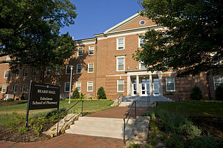
The UNC Eshelman School of Pharmacy is located at the University of North Carolina at Chapel Hill with a satellite campus at UNC Asheville; the satellite opened in 2011 and graduated its first class in 2015.
The 1996 U.S. Women's Open was the 51st U.S. Women's Open, held May 30 to June 2 at Pine Needles Lodge and Golf Club in Southern Pines, North Carolina.
Manly is an unincorporated community in Moore County, in the U.S. state of North Carolina.
References
Coordinates: 35°44′25″N79°01′53″W / 35.740278°N 79.031389°W
Municipalities and communities of Chatham County, North Carolina, United States | ||
|---|---|---|
| Towns |  | |
| CDPs | ||
| Other communities | ||
| Footnotes | ‡This populated place also has portions in an adjacent county or counties | |