Moncure, North Carolina

Last updated

Moncure, North Carolina
Moncure, North Carolina.jpg
Cluster of old buildings in Moncure; post office on the right
USA North Carolina location map.svg
Red pog.svg
Moncure
Coordinates: 35°37′26″N79°04′37″W / 35.62389°N 79.07694°W / 35.62389; -79.07694
Country United States
State North Carolina
County Chatham
Area
[1]
  Total4.91 sq mi (12.72 km2)
  Land4.73 sq mi (12.25 km2)
  Water0.18 sq mi (0.47 km2)
Elevation
[2]
223 ft (68 m)
Population
 (2020)
  Total780
  Density164.90/sq mi (63.67/km2)
Time zone UTC-5 (Eastern (EST))
  Summer (DST) UTC-4 (EDT)
ZIP code
27559
FIPS code 37-43880 [3]
GNIS feature ID2628645 [2]

Moncure, founded in 1881, is a small rural unincorporated community in southeastern Chatham County, North Carolina, United States. Moncure and the neighboring community of Haywood form the Moncure census-designated place (CDP), which had a population of 711 at the 2010 census. [4] The community is located near the confluence of the Deep and Haw rivers, which form the Cape Fear River. Moncure once served as the westernmost inland port in the state, linked to the Atlantic Ocean by steamships. [5]

Contents

Geography

Moncure is located in southeastern Chatham County. It is bordered on the south by the Deep River, which forms the boundary with Lee County to the south. The Moncure CDP includes the village of Moncure, plus the smaller community of Haywood to the east; both are located along Old US Highway 1. The CDP extends as far east as the Haw River and as far south as the junction of the Haw with the Deep River to form the Cape Fear River. U.S. Route 1, a four-lane expressway, passes through Moncure north of the village center, with access from Exit 79. US 1 leads northeast 28 miles (45 km) to Raleigh, the state capital, and southwest 12 miles (19 km) to Sanford. The area forms a salient or panhandle of Chatham County, lying between Wake and Lee counties.

According to the United States Census Bureau, the Moncure CDP has a total area of 4.9 square miles (12.8 km2), of which 4.7 square miles (12.2 km2) is land and 0.23 square miles (0.6 km2), or 4.61%, is water. [4]

The B. Everett Jordan Lake Dam is located just north of Moncure, and the area is home to much of Chatham County's heavy industry, including Shearon Harris Nuclear Power Plant 8 miles (13 km) to the east, and several plywood and lumber plants.

Demographics

Historical population
CensusPop.Note
2020 780
U.S. Decennial Census [6]

Institutions

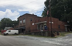
Moncure is home to a post office (ZIP code 27559), two convenience stores and an ABC store. The Moncure Volunteer Fire Department provides fire protection for the area. The department was founded May 4, 1966. There are two stations: Station 8 in Moncure at 2389 Old US 1 and Station 14 on Corinth Road at the intersection of Highway 42. The Moncure Fire Department Ladies auxiliary is the only active auxiliary in Chatham County.

Moncure and the nearby town of Pittsboro have an active artistic community. The defunct Moncure Museum of Modern Art is located within Moncure.

History

Moncure was founded in 1881 by Thomas Jefferson Moncure, Benjamin Gunter Womble (February 17, 1841 – February 15, 1916), Jake Wisseler, and James Everett Bryan. Thomas Moncure was an engineer for what became the Seaboard Air Line Railroad. Benjamin Womble was a Confederate veteran, owner of the Womble Hotel, and first[ citation needed ] postmaster of Moncure for 30 years. The old post office now resides on the Womble property that has been continuously owned by his family. [7]

The Newkirk State (Site 3lCH366) and Lockville Dam, Canal and Powerhouse are listed on the National Register of Historic Places. [8]

Related Research Articles

<span class="mw-page-title-main">Macon County, North Carolina</span> County in North Carolina, United States

Macon County is a county located in the U.S. state of North Carolina. As of the 2020 census, the population was 37,014. Its county seat is Franklin.

<span class="mw-page-title-main">Lee County, North Carolina</span> County in North Carolina, United States

Lee County is a county located in the U.S. state of North Carolina. As of the 2020 census, the population was 63,285. The county seat is Sanford. It was established on March 6, 1907, from parts of Chatham and Moore counties, and named for General Robert E. Lee, who served as the General in Chief of the Armies of the Confederate States in 1865.

<span class="mw-page-title-main">Chatham County, North Carolina</span> County in North Carolina, United States

Chatham County is a county located in the Piedmont area of the U.S. state of North Carolina. As of the 2020 census, the population was 76,285. Its county seat is Pittsboro.

<span class="mw-page-title-main">Alamance County, North Carolina</span> County in North Carolina, United States

Alamance County is a county in North Carolina. As of the 2020 census, the population was 171,415. Its county seat is Graham. Formed in 1849 from Orange County to the east, Alamance County has been the site of significant historical events, textile manufacturing, and agriculture.

<span class="mw-page-title-main">Saxapahaw, North Carolina</span> Census-designated place in North Carolina, United States

Saxapahaw is a census-designated place (CDP) and unincorporated area in Alamance County, North Carolina, United States. It is part of the Burlington, North Carolina Metropolitan Statistical Area. The population was 1,648 at the 2010 census.

<span class="mw-page-title-main">Fearrington Village, North Carolina</span> Census-designated place in North Carolina, United States

Fearrington Village is a residential development and census-designated place (CDP) in Chatham County, North Carolina, United States. The population was 2,339 at the 2010 census, up from 903 in 2000. Its name is phonetically pronounced FAIR-ington, not FEAR-ington as the spelling might indicate. The CDP occupies what was formerly the area of the unincorporated community of Farrington. It is a mixed-use community located on farmland dating back to the 18th century in Pittsboro, North Carolina. The community is located about 15 minutes from Chapel Hill, a half-hour from Durham and 45 minutes from Raleigh.

<span class="mw-page-title-main">Goldston, North Carolina</span> Town in North Carolina, United States

Goldston is a town in Chatham County, North Carolina, United States, south of Pittsboro. The population was 268 at the 2010 census.

<span class="mw-page-title-main">Pittsboro, North Carolina</span> Town in North Carolina, United States

Pittsboro is a town in Chatham County, North Carolina, United States. The population was 3,743 at the 2010 census and 4,537 at the 2020 census. It is the county seat of Chatham County.

<span class="mw-page-title-main">McLeansville, North Carolina</span> Census-designated place in North Carolina, United States

McLeansville is an unincorporated community and census-designated place (CDP) in Guilford County, North Carolina, United States. The population was 1,021 at the 2010 census.

<span class="mw-page-title-main">West Canton, North Carolina</span> Census-designated place in North Carolina, United States

West Canton is an unincorporated community and census-designated place (CDP) in Haywood County, North Carolina, United States. The population was 1,247 at the 2010 census. It is part of the Asheville Metropolitan Statistical Area.

<span class="mw-page-title-main">Sanford, North Carolina</span> City in North Carolina, United States

Sanford is a city in Lee County, North Carolina, United States. The population was 30,261 at the 2020 census. It is the county seat of Lee County.

Haywood is an unincorporated community in southeastern Chatham County, North Carolina, United States. It is part of the Moncure census-designated place. Along with several other unincorporated communities, it lies along the panhandle of Chatham County between Lee County and Wake County. Haywood lies at an elevation of 246 feet (75 m).

<span class="mw-page-title-main">Haw River</span> River in North Carolina, United States

The Haw River is a tributary of the Cape Fear River, approximately 110 mi (177 km) long, that is entirely contained in north central North Carolina in the United States. It was first documented as the "Hau River" by John Lawson, an English botanist, in his 1709 book "A New Voyage to Carolina." The name is shortened from Saxapahaw, from the Catawban /sak'yápha:/, "piedmont, foothill", from /sak/, "hill", plus /yápha:/, "step". The river gives its name to a small town that formed on its banks.

<span class="mw-page-title-main">Deep River (North Carolina)</span> River in North Carolina, USA

Deep River is a tributary of the Cape Fear River, approximately 125 miles (201 km) long, in north central North Carolina in the United States. Deep River is a translation of the Indian name sapponah, "deep river".

Advance is an unincorporated community and census-designated place (CDP) in Davie County, North Carolina, United States. It is seventy-five miles northeast of Charlotte. As of the 2010 census it had a population of 1,138. It is located along North Carolina Highway 801 just south of Bermuda Run. Advance is part of the Piedmont Triad region of North Carolina.

University is a census-designated place (CDP) and unincorporated community in Orange County, Florida, United States, east of Orlando. The community is centered around the University of Central Florida and includes a location on its south side known as University Park. The area is served by the zip codes 32816 and 32817. As of the 2010 census, the CDP had a population of 31,084. It is part of the Orlando–Kissimmee–Sanford, Florida Metropolitan Statistical Area.

<span class="mw-page-title-main">Gulf, North Carolina</span> Census-designated place in North Carolina, United States

Gulf is an unincorporated community and census-designated place (CDP) in southwestern Chatham County, North Carolina, United States, southeast of the town of Goldston. As of the 2010 census, the Gulf CDP had a population of 144. The community is home to a general store and several historic homes. It received its name from its location at a wide bend in the Deep River.

Mamers is an unincorporated community and census-designated place (CDP) in Harnett County, North Carolina, United States. The population was 826 at the 2010 census. It is a part of the Dunn Micropolitan Area, which is also a part of the greater Raleigh–Durham–Cary Combined Statistical Area (CSA) as defined by the United States Census Bureau.

Shaddox Creek is a 3.83 mi (6.16 km) long 3rd order tributary to the Haw River in Chatham County, North Carolina. Shaddox Creek is the only stream of this name in the United States.

<span class="mw-page-title-main">Cape Fear Township, Chatham County, North Carolina</span> Township in North Carolina, United States

Cape Fear Township, population 1,323, is one of thirteen townships in Chatham County, North Carolina. Cape Fear Township is 54.26 square miles (140.5 km2) in size and located in southeast Chatham County. Cape Fear Township does not contain any municipalities within it, but does contain Moncure, a census designated place.

References

  1. "ArcGIS REST Services Directory". United States Census Bureau. Retrieved September 20, 2022.
  2. 1 2 U.S. Geological Survey Geographic Names Information System: Moncure, North Carolina
  3. "U.S. Census website". United States Census Bureau . Retrieved January 31, 2008.
  4. 1 2 "Geographic Identifiers: 2010 Demographic Profile Data (G001): Moncure CDP, North Carolina". U.S. Census Bureau, American Factfinder. Archived from the original on February 12, 2020. Retrieved December 30, 2014.
  5. "Interesting Facts & Tidbits". County of Chatham, North Carolina. Retrieved April 23, 2012.
  6. "Census of Population and Housing". Census.gov. Retrieved June 4, 2016.
  7. Pendergrass, Esther Womble, "History of Moncure", The Sanford Herald , March 26, 1969.
  8. "National Register Information System". National Register of Historic Places . National Park Service. July 9, 2010.