
Scotland County is a county located in the southern part of the U.S. state of North Carolina. As of the 2020 census, the population was 34,174. Its county seat is Laurinburg.

Orange County is a county located in the Piedmont region of the U.S. state of North Carolina. As of the 2020 census, the population was 148,696. Its county seat is Hillsborough.

Chatham County is a county located in the Piedmont area of the U.S. state of North Carolina. As of the 2020 census, the population was 76,285. Its county seat is Pittsboro.

Caswell County is a county in the U.S. state of North Carolina. It is located in the Piedmont Triad region of the state. At the 2020 census, the population was 22,736. The county seat is Yanceyville.

Concord is a city in Cabarrus County, in the U.S. state of North Carolina. As of the 2020 census, the city had a population of 105,186, with an estimated population in 2021 of 107,697. It is the county seat and the largest city in Cabarrus County. In terms of population, the city of Concord is the second-largest city in the Charlotte metropolitan area and is the 10th most populous city in North Carolina.

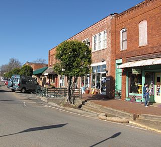
Yanceyville is a town in and the county seat of Caswell County, North Carolina, United States. It is located in the Piedmont Triad region of the state. At the 2020 census, the town had a population of 1,937.
Pittsboro is a town in Chatham County, North Carolina, United States. The population was 3,743 at the 2010 census and 4,537 at the 2020 census. It is the county seat of Chatham County.
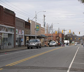
Siler City is a town in western Chatham County, North Carolina, United States. As of the 2020 census, the town's population was 7,702.
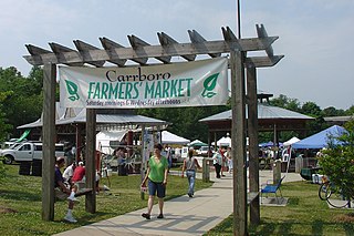
Carrboro is a town in Orange County in the U.S. state of North Carolina. The population was 21,295 at the 2020 census. The town, which is part of the Raleigh-Durham-Chapel Hill combined statistical area, was named after North Carolina industrialist Julian Shakespeare Carr.

Gibsonville is a town in both Alamance and Guilford counties in the U.S. state of North Carolina. Most of Gibsonville is situated in the Greensboro-Winston-Salem-High Point Combined Statistical Area and the eastern portion is in the Burlington, North Carolina Metropolitan Statistical Area, encompassing all of Alamance County. According to the 2020 Census, the population of Gibsonville was 8,971.

Cary is a town in Wake County and Chatham County, North Carolina. It is part of the Raleigh-Cary, NC Metropolitan Statistical Area. As of the 2020 Census, its population was 174,721, making it Wake County's second-largest municipality, the seventh-largest in North Carolina, and the 150th largest in the United States.

The Research Triangle, or simply The Triangle, are both common nicknames for a metropolitan area in the Piedmont region of North Carolina in the United States, anchored by the cities of Raleigh and Durham and the town of Chapel Hill, home to three major research universities: North Carolina State University, Duke University, and University of North Carolina at Chapel Hill, respectively. The nine-county region, officially named the Raleigh–Durham–Cary combined statistical area (CSA), comprises the Raleigh–Cary and Durham–Chapel Hill Metropolitan Statistical Areas and the Henderson Micropolitan Statistical Area. The "Triangle" name originated in the 1950s with the creation of Research Triangle Park, located between the three anchor cities and home to numerous high tech companies.

Bynum is an unincorporated community in northeastern Chatham County, North Carolina, United States on the banks of the Haw River. Bynum is five miles north of Pittsboro and 11 miles south of Chapel Hill. It is also known as Bynum Mill Village or Bynum Mill Hill.
Haywood is an unincorporated community in southeastern Chatham County, North Carolina, United States. It is part of the Moncure census-designated place. Along with several other unincorporated communities, it lies along the panhandle of Chatham County between Lee County and Wake County. Haywood lies at an elevation of 246 feet (75 m).
Hope Valley was the first full-fledged country club community in the suburbs of Durham, Durham County, North Carolina. It is developed around an 18-hole Donald Ross golf course. Created in 1925-26 just before the stock market crash of 1929, Hope Valley remained a unique rural colony until after World War II. Well outside the city limits Hope Valley was situated between Durham and Chapel Hill, and their university campuses, Duke and UNC Chapel Hill. It was one of North Carolina's first suburbs designed to be completely serviced by the automobile, well beyond urban transportation routes. It was listed on the National Register of Historic Places in 2009 as the Hope Valley Historic District, a national historic district.

Bonlee is an unincorporated community in western Chatham County, North Carolina, United States. It is located south of Siler City and north of Bear Creek along Old U.S. Route 421. Bonlee sits at an elevation of 518 feet (158 m). The community is home to several poultry feed mills and a K-8 school.

Coleridge is an unincorporated community along the Deep River in Randolph County, North Carolina, United States. It lies near Ramseur and southeast of Greensboro. Major roads through the town are Highway 22, which is joined in the middle by Highway 42, which then travels to Bennett.This community was named for James A. Cole, a local merchant. It is in the Eastern Standard Time zone UTC-5. The elevation is 436 feet. Former and merged names include Foust's Mill.
Farrington is an unincorporated community in Chatham County, North Carolina, United States. It is now part of the Fearrington Village census-designated place.

Cumnock, formerly known as Egypt, is an unincorporated community in northwestern Lee County, North Carolina, United States. It lies on Cumnock Road, about a mile north of U.S. Route 421.
Crutchfield Crossroads is an unincorporated community in northwestern Chatham County, North Carolina, United States, north of the town of Siler City. Crutchfield Crossroads is commonly defined as the area in and around the rural intersection of Silk Hope-Liberty Road. and Siler City- Snow Camp Road. At the intersection of the two roads, there are some stores, but other than that the entire community is agricultural. Children living in this area attend schools in Silk Hope and Siler City.
