
Pickaway County is a county in the U.S. state of Ohio. As of the 2020 census, the population was 58,539. Its county seat is Circleville. Its name derives from the Pekowi band of Shawnee Indians, who inhabited the area.

Madison County is a county located in the U.S. state of North Carolina. As of the 2020 census, the population was 21,193. Its county seat is Marshall. Madison County is part of the Asheville, NC Metropolitan Statistical Area.
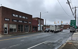
Walnut Cove is a town in Stokes County, North Carolina, United States. The population was 1,536 at the 2020 census.
U.S. Route 311 is a United States highway that runs for 62 mi (100 km) from Winston-Salem, North Carolina to near Danville, Virginia. It connects the cities of Winston-Salem, Madison, and Eden. The route runs northeast from Winston-Salem to Danville. By the numbering convention, it is an auxiliary route of US 11, however except for a brief period shortly after the route was established, it has not connected to its parent route.

U.S. Route 421 is a diagonal northwest–southeast United States Numbered Highway in the states of North Carolina, Tennessee, Virginia, Kentucky, and Indiana. The highway runs for 941 miles (1,514 km) from Fort Fisher, North Carolina, to US 20 in Michigan City, Indiana. Along its routing, US 421 serves several cities including Wilmington, North Carolina; Greensboro, North Carolina; Bristol, Tennessee and Virginia; Lexington, Kentucky; and Indianapolis, Indiana. US 421 is a spur route of US 21, which it meets west of Yadkinville, North Carolina.
State Route 32 is a primary state highway in the U.S. state of Virginia. The state highway runs 38.89 miles (62.59 km) from the North Carolina state line in Suffolk north to U.S. Route 17, US 258, and SR 143 in Newport News. The southernmost part of SR 32 connects Suffolk with the Albemarle Region of North Carolina via North Carolina Highway 32. The remainder of SR 32 runs concurrently with at least one other state or U.S. Highway between Suffolk and Newport News, including US 13, SR 10, US 258, and US 17. The last two highways run together with SR 32 on the James River Bridge.
U.S. Route 301 is a part of the U.S. Highway System that runs from Sarasota, Florida, to Biddles Corner, Delaware. In Virginia, the U.S. Highway runs 142.70 miles (229.65 km) from the North Carolina state line near Skippers north to the Maryland state line at the Potomac River near Dahlgren. US 301 forms the local complement to Interstate 95 (I-95) from Emporia to Petersburg. The U.S. Highway runs concurrently with US 1 between Petersburg and the state capital of Richmond, where the highways form one of the main north–south avenues. US 301 continues north concurrent with Virginia State Route 2 to Bowling Green, forming an eastern alternative to I-95 and US 1 north of Richmond. At Bowling Green, which is connected to I-95 by SR 207, US 301 becomes the primary highway connecting Richmond and the Northern Neck with Southern Maryland. US 301 was constructed in four main segments: as the original SR 24 and then US 17-1 south of Petersburg, as US 1 from Petersburg to Richmond, as SR 2 from Richmond to Bowling Green, and as part of SR 207 toward Dahlgren. US 301 replaced US 17–1 in the early 1930s and was extended from Petersburg north along its current course into Maryland when the Potomac River Bridge was completed in 1940.
U.S. Route 15 (US 15) is a part of the United States Numbered Highway System that runs from Walterboro, South Carolina, to Painted Post, New York. In Virginia, the U.S. Highway runs 230.37 miles (370.74 km) from the North Carolina state line near Clarksville north to the Maryland state line at the Potomac River near Lucketts. US 15 is a major north–south highway through the Piedmont of Virginia, connecting Clarksville and Farmville in Southside with Culpeper, Warrenton, and Leesburg in Northern Virginia.
U.S. Route 29 is a major north–south route in the Commonwealth of Virginia. It covers 248 miles (399 km) from the North Carolina border at the city of Danville to the Key Bridge in Washington, D.C. US 29 roughly bisects Virginia into eastern and western halves, and along with I-81 and US 11 in western Virginia, and I-85/95 as well as US 1 farther east, provides one of the major north–south routes through the Commonwealth.
U.S. Route 17 (US 17) is a part of the United States Numbered Highway System that runs from Punta Gorda, Florida, to Winchester, Virginia. In Virginia, the U.S. Highway runs 255.83 miles (411.72 km) from the North Carolina state line in Chesapeake north to its northern terminus at US 11, US 50, and US 522 in Winchester. US 17 is a major highway in the eastern half of Virginia. The U.S. Highway connects the Albemarle Region of North Carolina with the Hampton Roads metropolitan area. Within the urban area, US 17 passes through the South Hampton Roads cities of Chesapeake, Portsmouth, and Suffolk and the Virginia Peninsula city of Newport News. Between Yorktown and Fredericksburg, the U.S. Highway serves as the primary highway of the Middle Peninsula. At Fredericksburg, US 17 leaves the Atlantic Plain; the highway passes through the Piedmont town of Warrenton and crosses the Blue Ridge Mountains on its way to Winchester in the Shenandoah Valley. The route from Tappahannock to Winchester roughly follows the Confederate march during the Civil War to Gettysburg.

North Carolina Highway 213 (NC 213) is a primary state highway in the U.S. state of North Carolina. The highway connects Marshall with Walnut and Mars Hill.

Madison Township is one of ten townships in Daviess County, Indiana. As of the 2010 census, its population was 2,840 and it contained 1,233 housing units.

The Asheville metropolitan area is a metropolitan area centered on the principal city of Asheville, North Carolina. The U.S. Office of Management and Budget defines the Asheville, NC Metropolitan Statistical Area, a metropolitan statistical area used by the United States Census Bureau and other entities, as comprising the four counties of Buncombe, Haywood, Henderson, and Madison. The area's population was 424,858 according to the 2010 United States Census, and 469,454 according to the 2020 United States Census.
U.S. Route 23 (US 23) in the U.S. state of Georgia, is a north–south United States highway that travels from the St. Marys River south-southeast of Folkston to the North Carolina state line, in the northern part of Dillard. At nearly 392 miles (631 km) in length, it is the longest U.S. Highway in Georgia.

U.S. Route 441 (US 441) in the U.S. state of Georgia is a 354.2-mile-long (570.0 km) north–south United States Highway through the east-central portion of the state. It travels from the Florida state line near the Fargo city area to the North Carolina state line, in the northern part of Dillard. It is a spur route of US 41, although it has no intersections with its "parent" route within the state. It does have an intersection with another spur route of US 41 however, specifically US 341 in McRae–Helena.

Wolf Laurel, North Carolina, is an unincorporated, private gated community, located in Madison and Yancey Counties of Western North Carolina. The unincorporated community is located approximately 30 miles north of Asheville, North Carolina, 6 miles from interstate 26 and borders the Cherokee National Forest, Tennessee state line and Appalachian Trail. It is named after Wolf Laurel Branch, which flows into Puncheon Fork after leaving the community upstream.
Paint Rock is an unincorporated community in Madison County, North Carolina, United States. The community is named after the nearby mountain of the same name along the North Carolina–Tennessee state line. Located along the south banks of the French Broad River, the community is accessible via Paint Rock Road (SR 1300), which connects to US 25/US 70. The Norfolk Southern S-Line also travels through the community. The community is part of the Asheville Metropolitan Statistical Area.
White Rock is an unincorporated community in Madison County, North Carolina, United States. The community is located along Chapel Hill Road (SR 1316), which connects to nearby NC 212. The community is part of the Asheville Metropolitan Statistical Area.
Barnard is an unincorporated community in Madison County, North Carolina, United States. The community, originally known as Barnard's Station, was established as a post office as early as 1830; it was named for an early settler in the area. Located along the banks of the French Broad River, in central Madison County, the community is accessible via Barnard Road (SR 1151), which connects to NC 213. The Norfolk Southern S-Line also travels through the community. The community is part of the Asheville Metropolitan Statistical Area.
Faust is an unincorporated community in Madison County, North Carolina, United States. The community is nestled in the Walnut Mountains, located along Laurel Valley Road (SR 1503), which connects to nearby US 23A. The community is part of the Asheville Metropolitan Statistical Area.


