Raleigh is the capital of the state of North Carolina and the seat of Wake County in the United States. Raleigh is the second-largest city in the state, after Charlotte. Raleigh is known as the "City of Oaks" for its many oak trees, which line the streets in the heart of the city. The city covers a land area of 142.8 square miles (370 km2). The U.S. Census Bureau estimated the city's population as 479,332 as of July 1, 2018. It is one of the fastest-growing cities in the country. The city of Raleigh is named after Sir Walter Raleigh, who established the lost Roanoke Colony in present-day Dare County.

Jackson County is a county located in the southwest of the U.S. state of North Carolina. As of the 2010 census, the population was 40,271. Since 1913 its county seat has been Sylva, replacing Webster.

Edgecombe County is a county located in the U.S. state of North Carolina. As of the 2010 Census, the population was 56,552. Its county seat is Tarboro.

Tarboro is a town located in Edgecombe County, North Carolina, United States. It is part of the Rocky Mount Metropolitan Statistical Area. As of the 2010 census, the town had a population of 11,415. It is the county seat of Edgecombe County. Tarboro is located near the western edge of North Carolina's coastal plain. It has many historical churches, some dating from the early 19th century.

Wrightsville Beach is a town in New Hanover County, North Carolina, United States. Wrightsville Beach is just east of Wilmington and is part of the Wilmington Metropolitan Statistical Area. The population was 2,477 at the 2010 census. The town consists of a 4 miles (6 km) long beach island, an interior island called Harbor Island, and pockets of commercial property on the mainland.
A hurricane is a rapidly rotating storm system.
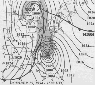
Hurricane Hazel was the deadliest and costliest hurricane of the 1954 Atlantic hurricane season. The storm killed at least 469 people in Haiti before striking the United States near the border between North and South Carolina as a Category 4 hurricane. After causing 95 fatalities in the US, Hazel struck Canada as an extratropical storm, raising the death toll by 81 people, mostly in Toronto. As a result of the high death toll and the damage caused by Hazel, its name was retired from use for North Atlantic hurricanes.
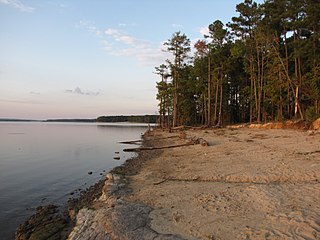
Jordan Lake State Recreation Area is a North Carolina state park spanning Chatham County, and Wake County North Carolina in the United States. It comprises 4,558 acres (18.45 km2) of woodlands along the shores of 13,940-acre (56 km2) Jordan Lake.

PNC Arena is an indoor arena located in Raleigh, North Carolina. The Arena seats 19,722 for basketball, and 18,680 for ice hockey, including 59 suites, 13 loge boxes and 2,000 club seats. The building has three concourses and a 300-seat restaurant.

Hurricane Ivan was a large, long-lived, Cape Verde hurricane that caused widespread damage in the Caribbean and United States. The cyclone was the ninth named storm, the sixth hurricane and the fourth major hurricane of the active 2004 Atlantic hurricane season. Ivan formed in early September, and reached Category 5 strength on the Saffir-Simpson Hurricane Scale. Ivan caused catastrophic damage to Grenada as a strong Category 3 storm, heavy damage to Jamaica as a strong Category 4 storm and then Grand Cayman, Cayman Islands and the western tip of Cuba as a Category 5 storm. After peaking in strength, the hurricane moved north-northwest across the Gulf of Mexico to strike Pensacola/Milton, Florida and Alabama as a strong Category 3 storm, causing significant damage. Ivan dropped heavy rains on the Southeastern United States as it progressed northeast and east through the eastern United States, becoming an extratropical cyclone. The remnant low from the storm moved into the western subtropical Atlantic and regenerated into a tropical cyclone, which then moved across Florida and the Gulf of Mexico into Louisiana and Texas, causing minimal damage. Ivan caused an estimated $26.1 billion along its path, of which $20.5 billion occurred in the United States.

The Swannanoa River flows through the Swannanoa Valley of western North Carolina, and is a major tributary to the French Broad River. It begins at its headwaters in Black Mountain, NC, however, it also has a major tributary near its headwaters: Flat Creek, which begins on the slopes of Mount Mitchell. The Swannanoa River ends when it meets the French Broad at Biltmore Estate in Asheville. The river is 22 miles or 35 kilometers long, and it flows entirely within the geographical boundaries of Buncombe County. It is a valuable resource to the county, providing drinking water to the Asheville metropolitan area, and numerous recreational opportunities. In September 2004, massive rains from the remnants of Hurricane Frances and Hurricane Ivan caused the Swannanoa to flood, causing major damage to the Biltmore Village section of Asheville, and to the other communities that it flows through.

The Chattooga River is the main tributary of the Tugaloo River. Its headwaters are located southwest of Cashiers, North Carolina, and it stretches 57 miles (92 km) to where it has its confluence with the Tallulah River within Lake Tugalo, held back by the Tugalo Dam. The Chattooga and the Tallulah combine to make the Tugaloo River starting at the outlet of Lake Tugalo. The Chattooga begins in southern Jackson County, North Carolina, then flows southwestward between northwestern Oconee County, South Carolina, and eastern Rabun County, Georgia. The "Chattooga" spelling was approved by the US Board on Geographic Names in 1897.
North Carolina Highway 12 (NC 12) is a 148.0-mile-long (238.2 km) primary state highway in the U.S. state of North Carolina, linking the peninsulas and islands of the northern Outer Banks. Most sections of NC 12 are two lanes wide, and there are also two North Carolina Ferry System routes which maintain continuity of the route as it traverses the Outer Banks region. NC 12 is part of the Outer Banks Scenic Byway, a National Scenic Byway. The first NC 12 appeared on the 1924 North Carolina Official Map and at its height ran from NC 30 in Pollocksville to NC 48 near Murfreesboro. Over time it was replaced by both US 258 and NC 58 and ceased to exist in 1958. The current NC 12 first appeared on the 1964 state highway map running from US 158 in Nags Head to Ocracoke. In 1976 NC 12 was extended to US 70 on the mainland and in 1987 was extended north to Corolla.
Sea Level is an unincorporated community in northeastern Carteret County, North Carolina. It rests on the banks of the Core Sound and has a population of roughly 450. It is located in what was known to early settlers as Hunting Quarters. Sea Level has one of the lowest elevations in North Carolina; it is estimated that approximately 75% of the community floods when hurricanes pass through. US 70 is the major thoroughfare through the community. The community is the location of NC 12's southern terminus.

State Route 16 is a primary state highway in the southwest part of the U.S. state of Virginia. It runs from the North Carolina border at North Carolina Highway 16 north to the West Virginia border at West Virginia Route 16, passing through the towns of Troutdale, Marion, and Tazewell.

Belews Creek is an unincorporated community in the Belews Creek Township of Forsyth County, North Carolina.
Roaring Creek is an unincorporated community in Avery County, North Carolina, United States. The community was named after Roaring Creek, which flows in the area. The community is located along US 19-E, between the communities of Frank and Plumtree.
Flat Creek is an unincorporated community in Buncombe County, North Carolina. Located along Old Mars Hill Highway (SR 2207), near the Future I-26/US 19/US 23 interchange. The community is named after Flat Creek, a tributary of the French Broad River.

Hurricane Florence was a powerful and long-lived Cape Verde hurricane that caused catastrophic damage in the Carolinas in September 2018, primarily as a result of freshwater flooding. Florence dropped a maximum total of 35.93 inches (913 mm) of rain in Elizabethtown, North Carolina, becoming the wettest tropical cyclone recorded in the Carolinas, and also the eighth-wettest overall in the contiguous United States. The sixth named storm, third hurricane, and the first major hurricane of the 2018 Atlantic hurricane season, Florence originated from a strong tropical wave that emerged off the west coast of Africa on August 30, 2018. Steady organization resulted in the formation of a tropical depression on the next day near Cape Verde. Progressing along a steady west-northwest trajectory, the system acquired tropical storm strength on September 1, and fluctuated in strength for several days over open ocean. An unexpected bout of rapid intensification ensued on September 4–5, culminating with Florence becoming a Category 4 major hurricane on the Saffir–Simpson scale (SSHWS), with estimated maximum sustained winds of 130 mph (215 km/h).