North Carolina Highway 208

Last updated

NC 208.svg

North Carolina Highway 208
NC 208 map.svg
Route information
Maintained by NCDOT
Length9.1 mi [1] (14.6 km)
Existed1921–present
Major junctions
South endUS 25.svgUS 70.svg US 25 / US 70 in Hurricane
North endTennessee 70.svg SR 70 at the Tennessee state line
Location
Counties Madison
Highway system
NC 207.svg NC 207 NC 209 NC 209.svg

North Carolina Highway 208 (NC 208) is a primary state highway in the U.S. state of North Carolina. The highway serves as the most direct route between Asheville and Greeneville, Tennessee, through the Bald Mountains.

A state highway, state road, or state route is usually a road that is either numbered or maintained by a sub-national state or province. A road numbered by a state or province falls below numbered national highways in the hierarchy. Roads maintained by a state or province include both nationally numbered highways and un-numbered state highways. Depending on the state, "state highway" may be used for one meaning and "state road" or "state route" for the other.

North Carolina State of the United States of America

North Carolina is a state in the southeastern region of the United States. It borders South Carolina and Georgia to the south, Tennessee to the west, Virginia to the north, and the Atlantic Ocean to the east. North Carolina is the 28th-most extensive and the 9th-most populous of the U.S. states. The state is divided into 100 counties. The capital is Raleigh, which along with Durham and Chapel Hill is home to the largest research park in the United States. The most populous municipality is Charlotte, which is the second-largest banking center in the United States after New York City.

Asheville, North Carolina City in North Carolina, United States

Asheville is a city and the county seat of Buncombe County, North Carolina, United States. It is the largest city in Western North Carolina, and the 12th-most populous city in the U.S. state of North Carolina. The city's population was 89,121 according to 2016 estimates. It is the principal city in the five-county Asheville metropolitan area, with a population of 424,858 in 2010.

Contents

Route description

NC 208 is a 9.1-mile (14.6 km) two-lane mountain highway that begins in the community of Hurricane and goes north hugging the banks of Big Laural Creek and (after a curved bridge) Shelton Laural Creek. Once at Belva, the highway goes northwest towards Greeneville, Tennessee, passing through the community of Allenstand, before reaching the state line at Allen Gap (2,234 ft (681 m), highest point on route). Just beyond the state line, the Appalachian Trail crosses the highway. [1] The entire highway is within the confines of the Pisgah National Forest.

Hurricane, North Carolina Unincorporated community in North Carolina, United States

Hurricane is an unincorporated community in Madison County, North Carolina, United States. The community is named after Little Hurricane Creek, a tributary of Big Laurel Creek. Centered at the intersection of US 25/US 70 and NC 208. The community is part of the Asheville Metropolitan Statistical Area.

Appalachian Trail Hiking trail in the USA

The Appalachian National Scenic Trail, generally known as the Appalachian Trail or simply the A.T., is a marked hiking trail in the Eastern United States extending between Springer Mountain in Georgia and Mount Katahdin in Maine. The trail is about 2,200 miles (3,500 km) long, though the exact length changes over time as parts are modified or rerouted. The Appalachian Trail Conservancy describes the Appalachian Trail as the longest hiking-only trail in the world. More than 2 million people are said to take a hike on part of the trail at least once each year.

Pisgah National Forest

Pisgah National Forest is a National Forest in the Appalachian Mountains of western North Carolina. It is administered by the United States Forest Service, part of the United States Department of Agriculture. The Pisgah National Forest is completely contained within the state of North Carolina. The forest is managed together with the other three North Carolina National Forests from common headquarters in Asheville, North Carolina. There are local ranger district offices located in Pisgah Forest, Mars Hill, and Nebo.

History

Established in 1921 as an original state highway and has not changed since. [2] [3]

Junction list

The entire route is in Madison County.

LocationmikmDestinationsNotes
Hurricane 0.00.0US 25.svgUS 70.svg US 25 / US 70  Hot Springs, Marshall, Asheville
Belva 3.55.6NC 212.svg NC 212 east White Rock Western terminus of NC 212
9.114.6Tennessee 70.svg SR 70 north Greeneville Tennessee state line
1.000 mi = 1.609 km; 1.000 km = 0.621 mi

Related Research Articles

U.S. Route 321 highway in the United States

U.S. Route 321 (US 321) is a spur of U.S. Route 21. It runs for 516.9 miles (831.9 km) from Hardeeville, South Carolina to Lenoir City, Tennessee; with both serving as southern termini. It reaches its northernmost point at Elizabethton, Tennessee. Because of its unusual "north–south–north" routing, U.S. Route 321 intersects both Interstate 40 and U.S. Route 70 three separate times. The highway serves different roles in each state: An alternate route to interstates in South Carolina, a major highway in North Carolina, and a scenic route in Tennessee.

North Carolina Highway 75 highway in North Carolina

North Carolina Highway 75 (NC 75) is a primary state highway in the U.S. state of North Carolina. Its entire length runs through Union County and serves as the primary connector between the towns of Waxhaw, Mineral Springs, and Monroe. The route roughly parallels a CSX railroad line for its entire span.

North Carolina Highway 83 highway in North Carolina

North Carolina Highway 83 (NC 83) is a primary state highway in the U.S. state of North Carolina. It serves to connect the towns of Maxton and Clio, South Carolina.

North Carolina Highway 7 highway in North Carolina

North Carolina Highway 7 (NC 7) is a primary state highway in the U.S. state of North Carolina. Entirely within Gaston County, it connects the towns of Lowell, McAdenville, and Belmont with the city of Gastonia.

North Carolina Highway 226 highway in North Carolina

North Carolina Highway 226 (NC 226) is a primary state highway in the U.S. state of North Carolina. Traveling north–south through Western North Carolina, it connects the cities and towns of Grover, Shelby, Marion, Spruce Pine and Bakersville. It also a scenic byway in the South Mountains area and connects with the summer colony of Little Switzerland, via NC 226A.

North Carolina Highway 8 highway in North Carolina

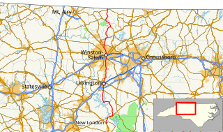
North Carolina Highway 8 (NC 8) is a primary state highway in the U.S. state of North Carolina. The route connects the cities of Lexington and Winston-Salem to various recreational and natural sites including Uwharrie National Forest, High Rock Lake and Hanging Rock State Park. NC 8 is part of a two-state, 151 mile highway 8 system.

North Carolina Highway 16 highway in North Carolina

North Carolina Highway 16 (NC 16) is a primary state highway in the U.S. state of North Carolina. Traveling north–south, it connects the cities of Charlotte, Conover, Taylorsville, Wilkesboro and Jefferson; linking the Charlotte metropolitan area with the High Country.

North Carolina Highway 345 highway in North Carolina

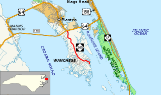
North Carolina Highway 345 (NC 345) is a primary state highway in the U.S. state of North Carolina connecting Wanchese and Manteo on Roanoke Island. The highway begins at The Lane and Thicket Lump Drive south of the town marina. Following Mill Landing Road through Wanchese, the road eventually becomes the western boundary for the Roanoke Island Marshes Dedicated Nature Preserve, before reaching its northern terminus at US 64.

North Carolina Highway 212 highway in North Carolina

North Carolina Highway 212 (NC 212) is a primary state highway in the U.S. state of North Carolina. The highway connects the White Rock community, through the Bald Mountains, in Madison County.

North Carolina Highway 213 highway in North Carolina

North Carolina Highway 213 (NC 213) is a primary state highway in the U.S. state of North Carolina. The highway connects Marshall with Walnut and Mars Hill.

North Carolina Highway 60 highway in North Carolina

North Carolina Highway 60 (NC 60) is a primary state highway in the extreme southwestern corner of North Carolina. The highway runs north–south from the Georgia state line to U.S. Route 64/U.S. Route 74 (US 64/US 74), near Ranger.

North Carolina Highway 143 highway in North Carolina

North Carolina Highway 143 (NC 143) is a primary state highway in the U.S. state of North Carolina. It runs from the Tennessee state line to NC 28, near the community of Stecoah. It is best known for its 18-mile (29 km) section of the Cherohala Skyway, shared with Tennessee State Route 165.

Interstate 40 (I-40) is a part of the Interstate Highway System that runs from Barstow, California to Wilmington, North Carolina. In North Carolina, I-40 enters the state along the Pigeon River Gorge, from Tennessee. Crossing the entire state, it connects the cities of Asheville, Winston-Salem, Greensboro, Durham and Raleigh before ending along U.S. Highway 117/North Carolina Highway 132 (US 117/NC 132) in Wilmington. The landscapes traversed by I-40 include the Blue Ridge Mountains, foothills of western North Carolina, suburban communities, the urban core of several Piedmont cities, along with eastern North Carolina farmland. At a total of 423.55 miles (681.64 km), it is the longest interstate highway in North Carolina. There are five auxiliary Interstates in the state related to I-40, as well as one business loop which currently runs through Winston-Salem. The route is labeled east-west for the entire route, however the eastern portion follows a much more north-south alignment.

North Carolina Highway 903 highway in North Carolina

North Carolina Highway 903 (NC 903) is a primary state highway in the U.S. state of North Carolina. It serves as predominantly rural highway in the Inner Banks region and arterial road in and around Greenville. The road covers a total of 200 miles (320 km), in a zigzag pattern through the state.

North Carolina Highway 61 highway in North Carolina

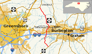
North Carolina Highway 61 (NC 61) is a primary state highway in the U.S. state of North Carolina. It serves as the main north–south highway in eastern Guilford County, connecting Whitsett and Gibsonville.

North Carolina Highway 281 highway in North Carolina

North Carolina Highway 281 (NC 281) is a primary state highway in the U.S. state of North Carolina. The highway runs north–south, connecting communities in western Jackson County and scenic areas of southwest Transylvania County. It is the only North Carolina state highway that changes numbers when crossing into South Carolina.

North Carolina Highway 209 highway in North Carolina

North Carolina Highway 209 (NC 209) is a primary state highway in the U.S. state of North Carolina. The highway runs north–south from Lake Junaluska to Hot Springs.

North Carolina Highway 180 highway in North Carolina

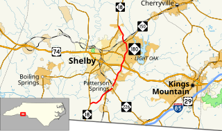
North Carolina Highway 180 (NC 180) is a primary state highway in the U.S. state of North Carolina. The highway serves as a bypass east of Shelby.

North Carolina Highway 138

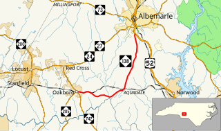
North Carolina Highway 138 (NC 138) is a primary state highway in the U.S. state of North Carolina. It serves to connect the community of Aquadale to nearby Oakboro and Albemarle.

North Carolina Highway 123

North Carolina Highway 123 (NC 123) is a primary state highway in the U.S. state of North Carolina. It serves as the main road through Hookerton and an alternate bypass of Snow Hill, entirely in Greene County.

References

  1. 1 2 Google (March 7, 2011). "NC 208" (Map). Google Maps . Google. Retrieved March 7, 2011.
  2. State Highway System of North Carolina (PDF) (Map). Cartography by NCDOT. North Carolina Department of Transportation. 1922. Retrieved May 7, 2015.
  3. State Highway System of North Carolina (PDF) (Map). Cartography by NCDOT. North Carolina Department of Transportation. 1930. Retrieved May 7, 2015.
KML file (edithelp)
    KML is from Wikidata