North Carolina Highway 207

Last updated

NC 207.svg

North Carolina Highway 207
Wolf Pond Road
NC 207 map.svg
Route information
Maintained by NCDOT
Length13.0 mi [1] (20.9 km)
Existed1948–present
Major junctions
South endSouth Carolina 207.svg SC 207 at the South Carolina state line
North endUS 74.svgUS 601.svgNC 200.svg US 74 / US 601 / NC 200 in Monroe
Location
Counties Union
Highway system
NC 205.svg NC 205 NC 208 NC 208.svg

North Carolina Highway 207 (NC 207) is a primary state highway in the U.S. state of North Carolina. It is entirely in the boundaries of Union County and serves to connect the city of Monroe to the city of Pageland, South Carolina, at the South Carolina state line via SC 207.

A state highway, state road, or state route is usually a road that is either numbered or maintained by a sub-national state or province. A road numbered by a state or province falls below numbered national highways in the hierarchy. Roads maintained by a state or province include both nationally numbered highways and un-numbered state highways. Depending on the state, "state highway" may be used for one meaning and "state road" or "state route" for the other.

North Carolina State of the United States of America

North Carolina is a state in the southeastern region of the United States. It borders South Carolina and Georgia to the south, Tennessee to the west, Virginia to the north, and the Atlantic Ocean to the east. North Carolina is the 28th-most extensive and the 9th-most populous of the U.S. states. The state is divided into 100 counties. The capital is Raleigh, which along with Durham and Chapel Hill is home to the largest research park in the United States. The most populous municipality is Charlotte, which is the second-largest banking center in the United States after New York City.

Union County, North Carolina County in North Carolina, United States

Union County is a county located in the U.S. state of North Carolina. As of the 2010 census, the population was 201,292. Its county seat is Monroe.

Contents

Route description

First sign for NC 207 after state line North NC 207.jpg
First sign for NC 207 after state line

From the North Carolina-South Carolina state line, NC 207 is a two-lane rural highway traversing north through rolling hills of farmland. Once it enters Monroe city limits, it becomes Haynes Street, where it connects several neighborhoods until it reaches the downtown business district. At Franklin Street, the road widens to four-lanes. At Church Street, it becomes Skyway Drive, continuing over the CSX rail yard it continue due north till it reaches Roosevelt Boulevard, where NC 207 ends at an interchange with US 74, US 601, and NC 200. Outside Monroe city limits, it is known and labeled as Wolf Pond Road. [1]

The terms city limit and city boundary refer to the defined boundary or border of a city. The area within the city limit is sometimes called the city proper. The terms town limit/boundary and village limit/boundary mean the same as city limit/boundary, but apply to towns and villages. Similarly, the term corporate limit is a legal name that refers to the boundaries of municipal corporations. In some countries, the limit of a municipality may be expanded through annexation.

CSX Transportation railway system in the United States of America

CSX Transportation is a Class I railroad operating in the eastern United States and the Canadian provinces of Ontario and Quebec. The railroad operates approximately 21,000 route miles (34,000 km) of track. The company operates as a subsidiary of CSX Corporation, a Fortune 500 company headquartered in Jacksonville, Florida.

U.S. Route 74 (US 74) is an east–west United States highway that runs for 515 miles (829 km) from Chattanooga, Tennessee to Wrightsville Beach, North Carolina. Predominantly in North Carolina, it serves as an important highway from the mountains to the sea, connecting the cities of Asheville, Charlotte and Wilmington.

History

The second and current NC 207 was established in 1948 as a new primary route from the South Carolina state line to US 74/NC 151/NC 200 (Franklin Street) in Monroe. The highway is a continuation of SC 207, which predates it. Between 1958-62, NC 207 was truncated at Morrow Street; and then was extended to Church Street between 1969 and 1982. [2] On August 2011, NC 207 was extended along Skyway Drive to US 74/US 601/NC 200 (Roosevelt Boulevard), after NC 200 was relocated bypassing west of Monroe. [3]

North Carolina Highway 151 highway in North Carolina

North Carolina Highway 151 is a north-south state highway located in western Buncombe County. NC 151 provides a direct access to the Blue Ridge Parkway from the west side of the Asheville vicinity.

The first NC 207 was created in 1926 as a short route from Forest City south to the South Carolina state line near Chesnee, South Carolina. This route was originally numbered as NC 206 but was changed by the North Carolina Department of Transportation for reasons unknown. Before being eliminated in 1933 with many other state routes, US 221 was selected to cover its span. This span was later re-signed as US 221A when a newer, more direct route was constructed bypassing Forest City and Spindale. [2]

Forest City, North Carolina Town in North Carolina, United States

Forest City, formerly known as "Burnt Chimney," is a town in Rutherford County, North Carolina, United States. The population was 7,476 as of the 2010 census, making it the largest municipality in Rutherford County.

Chesnee, South Carolina City in South Carolina, United States

Chesnee is a city in Spartanburg and Cherokee counties, in the U.S. state of South Carolina. The population was 868 as of the 2010 census., making it the smallest city of South Carolina in that census, although it is around nineteen times the size of South Carolina's smallest municipality, the town of Smyrna.

North Carolina Department of Transportation government agency

The North Carolina Department of Transportation (NCDOT) is responsible for building, repairing, and operating highways, bridges, and other modes of transportation, including ferries in the U.S. state of North Carolina.

Junction list

The entire route is in Union County.

Locationmi [1] kmDestinationsNotes
0.00.0South Carolina 207.svg SC 207 south South Carolina state line
Monroe 13.020.9US 74.svgUS 601.svgNC 200.svg US 74 / US 601 / NC 200 (Roosevelt Boulevard) Charlotte, Wadesboro, Pageland, Concord Interchange
1.000 mi = 1.609 km; 1.000 km = 0.621 mi

Related Research Articles

U.S. Route 601 (US 601) is a north–south United States highway that runs for 316.3 miles (509.0 km) from U.S. Route 321, near Tarboro, South Carolina, to U.S. Route 52, in Mount Airy, North Carolina.

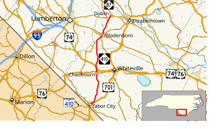
U.S. Route 701 is an auxiliary route of US 1 in the U.S. states of South Carolina and North Carolina. The U.S. Highway runs 171.45 miles (275.92 km) from US 17 and US 17 Alternate in Georgetown, South Carolina north to US 301, North Carolina Highway 96, and Interstate 95 (I-95) near Four Oaks, North Carolina. US 701 serves the Pee Dee region of South Carolina and the southern and central portions of Eastern North Carolina. The highway connects Georgetown and Conway in South Carolina with the North Carolina cities of Whiteville, Elizabethtown, Clinton, and a short distance north of its terminus, Smithfield. US 701 has four business routes in North Carolina, including those through Tabor City, Whiteville, Clarkton, and Clinton.

U.S. Route 176 highway in the United States

U.S. Route 176 is a spur of US 76 in the U.S. states of North Carolina and South Carolina. The U.S. Highway runs 237.98 miles (382.99 km) from US 25 Business and North Carolina Highway 225 in Hendersonville, North Carolina, east to US 52 in Goose Creek, South Carolina. US 176 serves the transition region between the Blue Ridge Mountains and Foothills of Western North Carolina and the Upstate, Midlands, and Lowcountry regions of South Carolina. The highway passes through and connects Spartanburg, one of two major cities in the Upstate, and Columbia, the South Carolina state capital and central city of the Midlands. US 176 parallels and serves as a secondary highway to Interstate 26 (I-26) except for between Spartanburg and Columbia, where the U.S. Highway deviates from the I-26 corridor to serve Union.

North Carolina Highway 24 highway in North Carolina

North Carolina Highway 24 (NC 24) is the longest primary state highway in the U.S. state of North Carolina. Traveling east–west between the Charlotte metropolitan area and the Crystal Coast, connecting the cities of Charlotte, Fayetteville, Jacksonville and Morehead City.

North Carolina Highway 51 highway in North Carolina

North Carolina Highway 51 (NC 51) is a primary state highway in the U.S. state of North Carolina entirely in Mecklenburg County. It connects the towns of Pineville, Matthews and Mint Hill.

North Carolina Highway 75 highway in North Carolina

North Carolina Highway 75 (NC 75) is a primary state highway in the U.S. state of North Carolina. Its entire length runs through Union County and serves as the primary connector between the towns of Waxhaw, Mineral Springs, and Monroe. The route roughly parallels a CSX railroad line for its entire span.

North Carolina Highway 84 highway in North Carolina

North Carolina Highway 84 (NC 84) is a primary state highway in the U.S. state of North Carolina. It serves to connect the town of Weddington to the city of Monroe.

South Carolina Highway 9 highway in South Carolina

South Carolina Highway 9 is a 258.3-mile-long (416 km) major state highway in the U.S. state of South Carolina. The route runs from North Myrtle Beach to the North Carolina border upstate. The road is currently the longest state highway in South Carolina. It is signed as a north–south highway though overall it runs in an east–west direction.

North Carolina Highway 16 highway in North Carolina

North Carolina Highway 16 (NC 16) is a primary state highway in the U.S. state of North Carolina. Traveling north–south, it connects the cities of Charlotte, Conover, Taylorsville, Wilkesboro and Jefferson; linking the Charlotte metropolitan area with the High Country.

North Carolina Highway 49 highway in North Carolina

North Carolina Highway 49 (NC 49) is a primary state highway in the U.S. state of North Carolina. It traverses much of the Piedmont region of North Carolina.

North Carolina Highway 87 highway in North Carolina

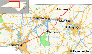
North Carolina Highway 87 (NC 87) is a primary state highway in the U.S. state of North Carolina. NC 87 begins in the Atlantic coastal town of Southport and crosses into Virginia at the Virginia state line five miles (8 km) north of Eden in Rockingham County. At 240 miles (390 km) in length, NC 87 is the second longest state highway in the U.S. state of North Carolina. Labeled as a north–south route, NC 87 travels along a relatively straight southeast–northwest path, connecting Cape Fear region with the Piedmont and connecting the cities of Fayetteville, Sanford, and Burlington.

North Carolina Highway 200 highway in North Carolina

North Carolina Highway 200 (NC 200) is a primary state highway in the U.S. state of North Carolina. The highway runs north–south from the South Carolina state line near the community of JAARS, to US 601 near Concord.

U.S. Route 76 in North Carolina highway in North Carolina

U.S. Highway 76 (US 76) is an east–west road in North Carolina running from the South Carolina state line to Wrightsville Beach. US 76 runs concurrently with US 74 for 52 miles (84 km) of the entire route in North Carolina. US 76 was first designated in North Carolina between late 1934 and 1935.

U.S. Route 221 in North Carolina highway in North Carolina

In the U.S. state of North Carolina U.S. Route 221 (US 221) is a north–south highway that travels through Western North Carolina. From Chesnee, South Carolina to Independence, Virginia, it connects the cities of Rutherfordton, Marion, Boone and Jefferson between the two out-of-state destinations. Its most memorable section, known as the Little Parkway Scenic Byway between Linville and Blowing Rock, offers area visitors a curvier alternative to the Blue Ridge Parkway and access to Grandfather Mountain.

Several special routes of U.S. Route 74 exist. In order from west to east they are as follows.

North Carolina Highway 78 highway in North Carolina

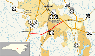
North Carolina Highway 78 (NC 78) is a primary state highway in the U.S. state of North Carolina. The highway connects the Tramway community with Sanford's Jonesboro Heights neighborhood.

South Carolina Highway 151 highway in South Carolina

South Carolina Highway 151 (SC 151) is a primary state highway in the U.S. state of South Carolina. Known as "the road to the beach", by many residents of the Charlotte metropolitan area due to it being the most direct route to the Grand Strand, it connects the Charlotte metropolitan area to Darlington, Florence, and the Grand Strand.

South Carolina Highway 207

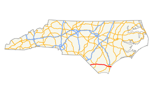
South Carolina Highway 207 (SC 207) is a primary state highway in the state of South Carolina. It is entirely within the boundaries of Chesterfield County and serves to connect the city of Pageland, South Carolina to the city of Monroe, North Carolina via North Carolina Highway 207 (NC 207).

South Carolina Highway 12

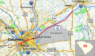
South Carolina Highway 12 (SC 12) is a state highway in the U.S. state of South Carolina. It serves Columbia and areas to its east. It serves as a parallel route to Interstate 20 (I-20) for much of its length.

North Carolina Highway 410

North Carolina Highway 410 (NC 410) is a primary state highway in the U.S. state of North Carolina. It serves as the central north–south highway in Columbus and Bladen Counties.

References

  1. 1 2 3 Google (February 3, 2013). "North Carolina Highway 207" (Map). Google Maps . Google. Retrieved February 3, 2013.
  2. 1 2 "NCRoads.com: N.C. 207" . Retrieved February 3, 2013.[ self-published source ]
  3. Route Change Request Form: NC 200, NC 75, NC 207, NC 84 (PDF) (Map). North Carolina Department of Transportation. August 15, 2011. Retrieved February 3, 2013.
KML file (edithelp)
    KML is from Wikidata