North Carolina Highway 200

Last updated

NC 200.svg

North Carolina Highway 200
NC 200 map.svg
Route information
Maintained by NCDOT
Length50.1 mi [1] (80.6 km)
Existed1930–present
Major junctions
South endSouth Carolina 200.svg SC 200 at the South Carolina state line
 
North endUS 601.svg US 601 near Concord
Location
Counties Union, Stanly, Cabarrus
Highway system
NC 198.svg NC 198 NC 205 NC 205.svg

North Carolina Highway 200 (NC 200) is a primary state highway in the U.S. state of North Carolina. The highway runs northsouth from the South Carolina state line near the community of JAARS, to US 601 near Concord.

A state highway, state road, or state route is usually a road that is either numbered or maintained by a sub-national state or province. A road numbered by a state or province falls below numbered national highways in the hierarchy. Roads maintained by a state or province include both nationally numbered highways and un-numbered state highways. Depending on the state, "state highway" may be used for one meaning and "state road" or "state route" for the other.

North Carolina State of the United States of America

North Carolina is a state in the southeastern region of the United States. It borders South Carolina and Georgia to the south, Tennessee to the west, Virginia to the north, and the Atlantic Ocean to the east. North Carolina is the 28th-most extensive and the 9th-most populous of the U.S. states. The state is divided into 100 counties. The capital is Raleigh, which along with Durham and Chapel Hill is home to the largest research park in the United States. The most populous municipality is Charlotte, which is the second-largest banking center in the United States after New York City.

South Carolina State of the United States of America

South Carolina is a state in the Southeastern United States and the easternmost of the Deep South. It is bordered to the north by North Carolina, to the southeast by the Atlantic Ocean, and to the southwest by Georgia across the Savannah River.

Contents

Route description

First sign for north NC 200 after the state line North NC 200.jpg
First sign for north NC 200 after the state line
End of NC 522 at NC 200 in Roughedge NC 522 End.jpg
End of NC 522 at NC 200 in Roughedge

NC 200 traverses 50.1 miles (80.6 km), starting at the South Carolina state line, through the city of Monroe, and the towns of Stanfield and Locust, before ending at US 601 near Concord. For its length, it is a two-lane rural highway except in Monroe where it is a four-lane road from Charlotte Avenue to US 74 and a six-lane divided highway on its concurrency with US 74 and US 601. [1]

Monroe, North Carolina City in North Carolina, United States

Monroe is a city in and the county seat of Union County, North Carolina, United States. The population increased from 26,228 in 2000 to 32,797 in 2010. It is within the rapidly growing Charlotte-Gastonia-Rock Hill, NC-SC Metropolitan area. Monroe has a council-manager form of government.

Stanfield, North Carolina Town in North Carolina, United States

Stanfield is a town in Stanly County, North Carolina, United States. The population was 1,486 at the 2010 census.

Locust, North Carolina City in North Carolina, United States

Locust is a small rural city in Stanly and Cabarrus counties in the U.S. state of North Carolina. The population was 2,930 at the 2010 census.

History

Established in 1930, it traveled from Monroe at US 74/NC 20/NC 25/NC 151 south to the South Carolina state line where it changed into SC 93 (renumbered to SC 200 in 1937). [2] Between 1931-36, NC 200 was realigned north of Old Highway Road near Jackson. In 1936, the highway was extended north via Franklin Street, Church Street, Winchester Street, and finally Morgan Mill Road to NC 27 in Locust. In 1942, the highway was extended again north to current terminus at NC 151 (renumbered to US 601 in 1951). [3]

North Carolina Highway 20 highway in North Carolina

North Carolina Highway 20 is a 27-mile (43 km) North Carolina state highway that runs through Hoke, Robeson and Bladen counties. It serves as a major road in each of the three incorporated communities through which it passes. The route is co-designated as St. Pauls Road in Raeford, Main Street in Lumber Bridge, and Broad Street in St. Pauls.

North Carolina Highway 151 highway in North Carolina

North Carolina Highway 151 is a north-south state highway located in western Buncombe County. NC 151 provides a direct access to the Blue Ridge Parkway from the west side of the Asheville vicinity.

South Carolina Highway 93 highway in South Carolina

South Carolina Highway 93 is a primary state highway in the U.S. state of South Carolina. It runs from U.S. Route 76 (US 76) and SC 28 in Clemson northeast to US 123 in Easley.

About 1958, NC 200 was rerouted in Monroe to follow Morrow Road and Haynes Street onto new bypass US 74/US 601, then return on Morgan Mill Road. By 1982, it had reverted to follow along Charlotte Avenue and Church Street. [3]

NC 200 was rerouted northwest on a new road around downtown Monroe in August 2011 utilizing Martin Luther King Boulevard and Dickerson Boulevard to connect with US 74. The old alignment, Lancaster Avenue and Charlotte Avenue to Franklin Street, was downgraded to a secondary road. NC 75 was extended, replacing NC 200 from Franklin Street to Haynes Street, via Charlotte Avenue and Church Street. NC 207 was also extended, replacing NC 200 from Church Street to US 74/US 601 (Roosevelt Boulevard), along Haynes Street/Skyway Drive. [4]

North Carolina Highway 75 highway in North Carolina

North Carolina Highway 75 (NC 75) is a primary state highway in the U.S. state of North Carolina. Its entire length runs through Union County and serves as the primary connector between the towns of Waxhaw, Mineral Springs, and Monroe. The route roughly parallels a CSX railroad line for its entire span.

North Carolina Highway 207 highway in North Carolina

North Carolina Highway 207 (NC 207) is a primary state highway in the U.S. state of North Carolina. It is entirely in the boundaries of Union County and serves to connect the city of Monroe to the city of Pageland, South Carolina, at the South Carolina state line via SC 207.

Junction list

CountyLocationmi [1] kmDestinationsNotes
Union 0.00.0South Carolina 200.svg SC 200 westSouthern terminus; South Carolina state line
Roughedge 9.014.5NC 522.svg NC 522 south (Rocky River Road)Northern terminus of NC 522
Monroe 15.324.6NC 75.svg NC 75 west (Waxhaw Highway) Waxhaw One-quadrant interchange; eastern terminus of NC 75
15.725.3NC 84.svg NC 84 (Weddington Road) Weddington Eastern terminus of NC 84
17.828.6US 74.svg US 74 east (Roosevelt Boulevard) Charlotte South end of US 74 overlap
18.3–
18.5
29.5–
29.8
Concord AvenueInterchange
18.830.3US 601.svgNC 207.svg US 601 north / NC 207 south (Skyway Drive) Concord, Monroe Business District Interchange; south end of US 601 overlap
20.032.2US 74.svgUS 601.svg US 74 east / US 601 south (Roosevelt Boulevard) Wadesboro, Pageland North end of US 74/US 601 overlaps
By-pass plate white and toll plate yellow.svg
US 74.svg US 74 Byp. (Monroe Expressway) Charlotte, Rockingham
All-electronic toll road
31.450.5NC 218.svg NC 218  Mint Hill, New Salem
Stanly Locust 41.967.4NC 24.svgNC 27.svg NC 24 / NC 27  Charlotte, Albemarle
Cabarrus 50.180.6US 601.svg US 601  Concord, Monroe Northern terminus
1.000 mi = 1.609 km; 1.000 km = 0.621 mi

See also

Related Research Articles

U.S. Route 74 (US 74) is an east–west United States highway that runs for 515 miles (829 km) from Chattanooga, Tennessee to Wrightsville Beach, North Carolina. Predominantly in North Carolina, it serves as an important highway from the mountains to the sea, connecting the cities of Asheville, Charlotte and Wilmington.

U.S. Route 601 (US 601) is a north–south United States highway that runs for 316.3 miles (509.0 km) from U.S. Route 321, near Tarboro, South Carolina, to U.S. Route 52, in Mount Airy, North Carolina.

North Carolina Highway 24 highway in North Carolina

North Carolina Highway 24 (NC 24) is the longest primary state highway in the U.S. state of North Carolina. Traveling east–west between the Charlotte metropolitan area and the Crystal Coast, connecting the cities of Charlotte, Fayetteville, Jacksonville and Morehead City.

North Carolina Highway 51 highway in North Carolina

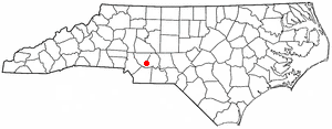
North Carolina Highway 51 (NC 51) is a primary state highway in the U.S. state of North Carolina entirely in Mecklenburg County. It connects the towns of Pineville, Matthews and Mint Hill.

North Carolina Highway 84 highway in North Carolina

North Carolina Highway 84 (NC 84) is a primary state highway in the U.S. state of North Carolina. It serves to connect the town of Weddington to the city of Monroe.

North Carolina Highway 16 highway in North Carolina

North Carolina Highway 16 (NC 16) is a primary state highway in the U.S. state of North Carolina. Traveling north–south, it connects the cities of Charlotte, Conover, Taylorsville, Wilkesboro and Jefferson; linking the Charlotte metropolitan area with the High Country.

North Carolina Highway 50 highway in North Carolina

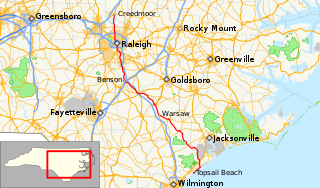
North Carolina Highway 50 (NC 50) is a primary state highway in the U.S. state of North Carolina. It traverses north–south, from Topsail Beach to Creedmoor, connecting the cities of Warsaw, Newton Grove, Benson, and Raleigh.

North Carolina Highway 11 highway in North Carolina

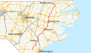
North Carolina Highway 11 (NC 11) is a primary state highway in the U.S. state of North Carolina. Traveling 193.2 miles (310.9 km), in a north–south alignment through Eastern North Carolina, it connects the towns and cities of Wallace, Kenansville, Kinston, Greenville and Murfreesboro.

North Carolina Highway 49 highway in North Carolina

North Carolina Highway 49 (NC 49) is a primary state highway in the U.S. state of North Carolina. It traverses much of the Piedmont region of North Carolina.

North Carolina Highway 97 highway in North Carolina

North Carolina Highway 97 (NC 97) is a primary state highway in the U.S. state of North Carolina, connecting the cities of Zebulon and Rocky Mount with the vast rural coastal plains.

North Carolina Highway 27 highway in North Carolina

North Carolina Highway 27 (NC 27) is a primary state highway in the U.S. state of North Carolina. The route traverses 198 miles (319 km) through southern and central North Carolina, about 100 miles (160 km) of it as a concurrency with NC 24.

North Carolina Highway 130 highway in North Carolina

North Carolina Highway 130 (NC 130) is a primary state highway in the U.S. state of North Carolina. The highway serves the towns and rural communities in southern Robeson County, acts as a direct route between Whiteville and Shallotte through the Green Swamp, and provides access to Holden Beach.

North Carolina Highway 98 highway in North Carolina

North Carolina Highway 98 (NC 98) is a primary state highway in the U.S. state of North Carolina and a semi-urban traffic artery connecting Durham, Wake Forest, and Bunn as well as many small to medium-sized towns in the north portion of The Triangle region of North Carolina. Running from downtown Durham, the route leaves the city to the east, running into a rural area near Falls Lake. As the road approaches Wake Forest, it widens to a four-lane divided highway and runs along the southern side of the city. Once leaving Wake Forest NC 98 becomes a two lane road again, running through rural areas east of Bunn. After a short concurrency with NC 39, NC 98 continues southeast to reach its eastern terminus at US 64 Alternate and NC 231 west of Spring Hope.

U.S. Route 220 in North Carolina highway in North Carolina

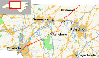
In the U.S. state of North Carolina, U.S. Route 220 is a north–south highway that connects the cities of Rockingham, Asheboro and Greensboro, in the central Piedmont.

North Carolina Highway 81 highway in North Carolina

North Carolina Highway 81 (NC 81) is a primary state highway in the U.S. state of North Carolina. That runs entirely in Asheville and Buncombe County from US 25 to US 70.

Several special routes of U.S. Route 74 exist. In order from west to east they are as follows.

North Carolina Highway 78 highway in North Carolina

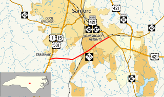
North Carolina Highway 78 (NC 78) is a primary state highway in the U.S. state of North Carolina. The highway connects the Tramway community with Sanford's Jonesboro Heights neighborhood.

References

  1. 1 2 3 Google (January 26, 2013). "North Carolina Highway 200" (Map). Google Maps . Google. Retrieved January 26, 2013.
  2. "Mapmikey's South Carolina Highways Page" . Retrieved June 26, 2011.[ unreliable source ]
  3. 1 2 "NCRoads.com: N.C. 200" . Retrieved January 26, 2013.[ unreliable source ]
  4. Route Change Request Form: NC 200, NC 75, NC 207, NC 84 (PDF) (Map). North Carolina Department of Transportation. August 15, 2011. Retrieved January 27, 2013.
KML file (edithelp)
    KML is from Wikidata