North Carolina Highway 205

Last updated

NC 205.svg

North Carolina Highway 205
NC 205 map.svg
Route information
Maintained by NCDOT
Length 22.0 mi [1] (35.4 km)
Existed 1935 [2] – present
Major junctions
South endUS 74.svg US 74 in Marshville
North endNC 24.svgNC 27.svg NC 24 / NC 27 in Red Cross
Location
Counties Union, Stanly
Highway system
NC 200.svg NC 200 NC 207 NC 207.svg

North Carolina Highway 205 (NC 205) is a primary state highway in the U.S. state of North Carolina. It traverses 22 miles (35 km) in Stanly and Union Counties.

A state highway, state road, or state route is usually a road that is either numbered or maintained by a sub-national state or province. A road numbered by a state or province falls below numbered national highways in the hierarchy. Roads maintained by a state or province include both nationally numbered highways and un-numbered state highways. Depending on the state, "state highway" may be used for one meaning and "state road" or "state route" for the other.

North Carolina State of the United States of America

North Carolina is a state in the southeastern region of the United States. It borders South Carolina and Georgia to the south, Tennessee to the west, Virginia to the north, and the Atlantic Ocean to the east. North Carolina is the 28th-most extensive and the 9th-most populous of the U.S. states. The state is divided into 100 counties. The capital is Raleigh, which along with Durham and Chapel Hill is home to the largest research park in the United States. The most populous municipality is Charlotte, which is the second-largest banking center in the United States after New York City.

Stanly County, North Carolina County in the United States

Stanly County is a county in the U.S. state of North Carolina. As of the 2010 census, the population was 60,585. Its county seat is Albemarle.

Contents

Route description

NC 205 is a two-lane rural highway that goes through mostly farmland, as it connects the towns of Marshville, Oakboro, and Red Cross.

Marshville, North Carolina Town in North Carolina, United States

Marshville is a town in Union County, North Carolina, United States. Its population was 2,402 at the 2010 census. Marshville is known as the birthplace of country music singer Randy Travis.

Oakboro, North Carolina Town in North Carolina, United States

Oakboro is a town in Stanly County, North Carolina, United States. The population was 1,859 at the 2010 census.

Red Cross is a town in Stanly County, North Carolina, United States. The population was 742 as of the 2010 Census.

History

Established in 1935, it is the second incarnation NC 205, creating a new primary routing between the towns of Marshville and Red Cross. In the late 1940s, it was extended southwest along Main Street to the new alignment of US 74; it then changed by 1953 onto a new extension of Elm Street to US 74, leaving Main Street. [2]

U.S. Route 74 (US 74) is an east–west United States highway that runs for 515 miles (829 km) from Chattanooga, Tennessee to Wrightsville Beach, North Carolina. Predominantly in North Carolina, it serves as an important highway from the mountains to the sea, connecting the cities of Asheville, Charlotte and Wilmington.

The first NC 205 was an original state highway (1921), connecting Kings Mountain to Grover. In 1926, US 29 was added to all of NC 205. In late 1934, NC 205 was dropped, leaving behind US 29 and NC 216. [2]

Kings Mountain, North Carolina City in North Carolina, United States

Kings Mountain is a small suburban city within the Charlotte metropolitan area in Cleveland and Gaston counties, North Carolina, United States. Most of the city is in Cleveland County, with a small eastern portion in Gaston County. The population was 10,296 at the 2010 census. During the Revolutionary War, Patriot militia defeated Loyalist militia in the Battle of Kings Mountain.

Grover, North Carolina Town in North Carolina, United States

Grover is a town in Cleveland County, North Carolina, United States. The population was 708 at the 2010 census.

U.S. Route 29 in North Carolina highway in North Carolina

U.S. Route 29 is a north–south United States highway that runs for 168 miles (270 km) from the South Carolina state line, near Blacksburg, to the commonwealth of Virginia, near Danville. The route serves the North Carolina Piedmont, including the cities of Charlotte, Salisbury, High Point, and Greensboro.

Junction list

CountyLocationmi [1] kmDestinationsNotes
Union Marshville 0.00.0US 74.svg US 74 (Marshville Boulevard) / Elm Street
New Salem 10.817.4NC 218.svg NC 218  Mint Hill, Polkton
Stanly Oakboro 18.429.6NC 742.svg NC 742 south (Main Street) / East 2nd Street Wadesboro Northern terminus of NC 742
Red Cross 22.035.4NC 24.svgNC 27.svg NC 24 / NC 27 (Red Cross Road) / Oak Ridge Road Charlotte, Albemarle
1.000 mi = 1.609 km; 1.000 km = 0.621 mi

Related Research Articles

North Carolina Highway 51 highway in North Carolina

North Carolina Highway 51 (NC 51) is a primary state highway in the U.S. state of North Carolina entirely in Mecklenburg County. It connects the towns of Pineville, Matthews and Mint Hill.

North Carolina Highway 75 highway in North Carolina

North Carolina Highway 75 (NC 75) is a primary state highway in the U.S. state of North Carolina. Its entire length runs through Union County and serves as the primary connector between the towns of Waxhaw, Mineral Springs, and Monroe. The route roughly parallels a CSX railroad line for its entire span.

North Carolina Highway 84 highway in North Carolina

North Carolina Highway 84 (NC 84) is a primary state highway in the U.S. state of North Carolina. It serves to connect the town of Weddington to the city of Monroe.

North Carolina Highway 7 highway in North Carolina

North Carolina Highway 7 (NC 7) is a primary state highway in the U.S. state of North Carolina. Entirely within Gaston County, it connects the towns of Lowell, McAdenville, and Belmont with the city of Gastonia.

North Carolina Highway 226 highway in North Carolina

North Carolina Highway 226 (NC 226) is a primary state highway in the U.S. state of North Carolina. Traveling north–south through Western North Carolina, it connects the cities and towns of Grover, Shelby, Marion, Spruce Pine and Bakersville. It also a scenic byway in the South Mountains area and connects with the summer colony of Little Switzerland, via NC 226A.

North Carolina Highway 9 highway in North Carolina

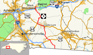
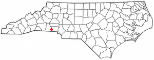
North Carolina Highway 9 (NC 9) is a 46.4-mile (74.7 km) primary state highway in the U.S. state of North Carolina. It serves as a connector route from South Carolina Highway 9 to eastern portions of the Appalachians around Asheville.

North Carolina Highway 211 highway in North Carolina

North Carolina Highway 211 (NC 211) is a 162.5-mile-long (261.5 km) primary state highway in the U.S. state of North Carolina. It traverses mostly through the Sandhills and Coastal Plain regions of the state; connecting the cities of Candor, Aberdeen, Raeford, Lumberton, Bladenboro, and Southport.

North Carolina Highway 11 highway in North Carolina

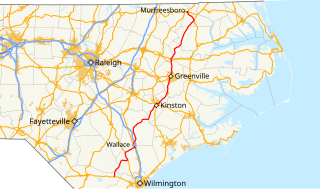
North Carolina Highway 11 (NC 11) is a primary state highway in the U.S. state of North Carolina. Traveling 193.2 miles (310.9 km), in a north–south alignment through Eastern North Carolina, it connects the towns and cities of Wallace, Kenansville, Kinston, Greenville and Murfreesboro.

North Carolina Highway 49 highway in North Carolina

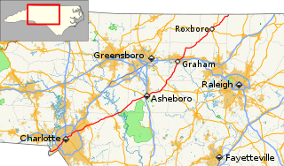
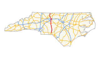
North Carolina Highway 49 (NC 49) is a primary state highway in the U.S. state of North Carolina. It traverses much of the Piedmont region of North Carolina.

North Carolina Highway 87 highway in North Carolina

North Carolina Highway 87 (NC 87) is a primary state highway in the U.S. state of North Carolina. NC 87 begins in the Atlantic coastal town of Southport and crosses into Virginia at the Virginia state line five miles (8 km) north of Eden in Rockingham County. At 240 miles (390 km) in length, NC 87 is the second longest state highway in the U.S. state of North Carolina. Labeled as a north–south route, NC 87 travels along a relatively straight southeast–northwest path, connecting Cape Fear region with the Piedmont and connecting the cities of Fayetteville, Sanford, and Burlington.

North Carolina Highway 27 highway in North Carolina

North Carolina Highway 27 (NC 27) is a primary state highway in the U.S. state of North Carolina. The route traverses 198 miles (319 km) through southern and central North Carolina, about 100 miles (160 km) of it as a concurrency with NC 24.

North Carolina Highway 68 highway in North Carolina

North Carolina Highway 68 (NC 68) is a north–south state highway in North Carolina. It serves as a connector between Interstate 40 (I-40)/ US 421 and Piedmont Triad International Airport. On its routing from Thomasville to Stokesdale, NC 68 passes through urban High Point, the western outskirts of Greensboro, and the town of Oak Ridge. The segment from just north of the I-40/US 421 interchange to Pleasant Ridge Road in Guilford County is a limited access freeway.

North Carolina Highway 268 highway in North Carolina

North Carolina Highway 268 (NC 268) is a primary state highway in the U.S. state of North Carolina. It connects many communities as it traverses through the northwestern North Carolina mountains and foothills.

North Carolina Highway 94 highway in North Carolina

North Carolina Highway 94 (NC 94) is a primary state highway in the U.S. state of North Carolina. It runs from Hyde County in Swan Quarter to Chowan County near Edenton.

U.S. Route 220 in North Carolina highway in North Carolina

In the U.S. state of North Carolina, U.S. Route 220 is a north–south highway that connects the cities of Rockingham, Asheboro and Greensboro, in the central Piedmont.

North Carolina Highway 43 highway in North Carolina

North Carolina Highway 43 (NC 43) is a primary state highway in the U.S. state of North Carolina. It connects many towns in the Coastal Plain region.

North Carolina Highway 581 highway in North Carolina

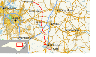
North Carolina Highway 581 (NC 581) is a primary state highway in the U.S. state of North Carolina. The highway travels from Goldsboro to Louisburg, connecting various rural communities in between.

North Carolina Highway 742

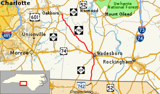
North Carolina Highway 742 (NC 742) is a primary state highway in the U.S. state of North Carolina. It connects the city of Wadesboro with the towns of Oakboro and Chesterfield, South Carolina.

North Carolina Highway 710

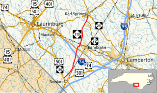
North Carolina Highway 710 (NC 710) is a primary state highway in the U.S. state of North Carolina. It connects the town of Pembroke to Interstate 74 (I-74) and U.S. Route 74 and the nearby towns of Red Springs and Rowland.

References

KML file (edithelp)
KML is from Wikidata
  1. 1 2 Google (May 7, 2015). "North Carolina Highway 205" (Map). Google Maps . Google. Retrieved May 7, 2015.
  2. 1 2 3 "NCRoads.com: N.C. 205". Archived from the original on November 25, 2010. Retrieved 2011-06-26.[ self-published source ]