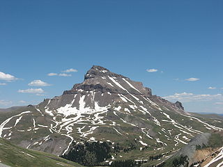
The San Juan Mountains is a high and rugged mountain range in the Rocky Mountains in southwestern Colorado and northwestern New Mexico. The area is highly mineralized and figured in the gold and silver mining industry of early Colorado. Major towns, all old mining camps, include Creede, Lake City, Silverton, Ouray, and Telluride. Large scale mining has ended in the region, although independent prospectors still work claims throughout the range. The last large-scale mines were the Sunnyside Mine near Silverton, which operated until late in the 20th century, and the Idarado Mine on Red Mountain Pass, which closed in the 1970s. Famous old San Juan mines include the Camp Bird and Smuggler Union mines, both located between Telluride and Ouray.

Watauga County is a county located in the U.S. state of North Carolina. As of the 2020 census, the population was 54,086. Its county seat and largest community is Boone. The county is in an exceptionally mountainous region, known as the High Country. It is the home of Appalachian State University, which has approximately 20,023 students as of August 2020. Watauga County comprises the Boone, NC Micropolitan Statistical Area.

Madison County is a county located in the U.S. state of North Carolina. As of the 2020 census, the population was 21,193. Its county seat is Marshall. Madison County is part of the Asheville, NC Metropolitan Statistical Area.

Seven Devils is a town in Avery and Watauga counties in the U.S. state of North Carolina. The population was 313 at the 2020 census. The town, which is located in the Appalachian Mountains, is best known as the site of a popular wintertime tubing resort known as Hawksnest, which claims it has the largest tubing facility on the East Coast, and some of the town's year round residents earn their living at the resort. Many others are retirees. Developed in the 1970s as a vacation home community, Seven Devils is home mostly to seasonal residents.

Highlands is an incorporated town in Macon County in the U.S. state of North Carolina. Located on a plateau in the southern Appalachian Mountains, within the Nantahala National Forest, it lies mostly in southeastern Macon County and slightly in southwestern Jackson County, in the Highlands and Cashiers Townships, respectively. The permanent population was 1,014 at the 2020 census.

Mount San Antonio, commonly referred to as Mount Baldy or Old Baldy, is a 10,064 ft (3,068 m) summit in the San Gabriel Mountains on the border of Los Angeles and San Bernardino counties of California. Lying within the San Gabriel Mountains National Monument and Angeles National Forest, it is the high point of the range, the County of Los Angeles, and the Los Angeles metropolitan area.

Snowshoe is an unincorporated community in Pocahontas County, West Virginia, United States, centering on the Snowshoe Mountain ski resort. It is situated in the Allegheny Mountains at a bowl shaped convergence of two high mountain ridges — Cheat and Back Allegheny Mountains — at the head of the Shavers Fork of the Cheat River. Snowshoe is site of the second highest point in the state and the peak elevation for Cheat Mountain, at Thorny Flat, which reaches 4,848 feet (1,478 m) above sea level.

The Midstate Trail is a scenic footpath which runs 92 miles (148 km) through Worcester County, Massachusetts, from the Rhode Island border to the New Hampshire border, approximately 45 miles (72 km) west of Boston. The trail is considered highly accessible, scenic, and remarkably rural despite its proximity to urban Boston. The trail includes the summits of Mount Wachusett and Mount Watatic, as well as many interesting geologic, historic, and natural features.

Roan Mountain State Park is a Tennessee state park in Carter County, in Northeast Tennessee. It is close to the Tennessee-North Carolina border and near the community of Roan Mountain, Tennessee. Situated in the Blue Ridge of the Appalachian Mountains, the park preserves 2,006 acres (8.12 km2) of mostly hardwood forest. The park is in close proximity to 6,285-foot (1,916 m) Roan Mountain and the Appalachian Trail, both of which are owned and managed by the US Forest Service. On exceptionally clear days, the Charlotte skyline can be photographed from the peak. Most of the town of Roan Mountain is privately owned by the residence, and much of the land in Roan Mountain has been family owned for many generations, being passed down generation after generation through the years.

Western North Carolina is the region of North Carolina which includes the Appalachian Mountains; it is often known geographically as the state's Mountain Region. It contains the highest mountains in the Eastern United States, with 125 peaks rising to over 5,000 feet in elevation. Mount Mitchell at 6,684 feet, is the highest peak of the Appalachian Mountains and mainland eastern North America. The population of the 23 most commonly associated counties for the region, as measured by the 2020 U.S. Census, is 1,149,405. The region accounts for approximately 11% of North Carolina's total population.

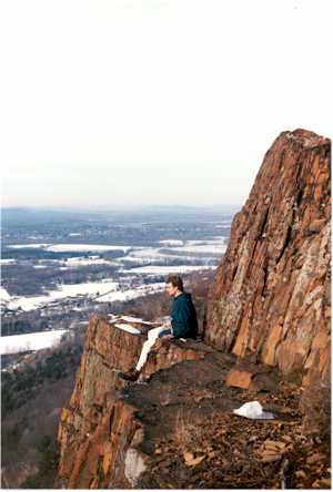
The Metacomet-Monadnock Trail is a 114-mile-long (183 km) hiking trail that traverses the Metacomet Ridge of the Pioneer Valley region of Massachusetts and the central uplands of Massachusetts and southern New Hampshire. Although less than 70 miles (110 km) from Boston and other large population centers, the trail is considered remarkably rural and scenic and includes many areas of unique ecologic, historic, and geologic interest. Notable features include waterfalls, dramatic cliff faces, exposed mountain summits, woodlands, swamps, lakes, river floodplain, farmland, significant historic sites, and the summits of Mount Monadnock, Mount Tom and Mount Holyoke. The Metacomet-Monadnock Trail is maintained largely through the efforts of the Western Massachusetts Chapter of the Appalachian Mountain Club (AMC). Much of the trail is a portion of the New England National Scenic Trail.
The Appalachian National Scenic Trail spans 14 U.S. states over its roughly 2,200 miles (3,500 km): Georgia, North Carolina, Tennessee, Virginia, West Virginia, Maryland, Pennsylvania, New Jersey, New York, Connecticut, Massachusetts, Vermont, New Hampshire, and Maine. The southern end is at Springer Mountain, Georgia, and it follows the ridgeline of the Appalachian Mountains, crossing many of its highest peaks and running almost continuously through wilderness before reaching the northern end at Mount Katahdin, Maine.

Laurel Ridge State Park is a 13,625-acre (5,514 ha) Pennsylvania state park that with parcels in Cambria, Fayette, Somerset, and Westmoreland counties, Pennsylvania in the United States.

The Monadnock-Sunapee Greenway (MSG) is a 50-mile (80 km) hiking trail that traverses the highlands of southern New Hampshire from Mount Monadnock in Jaffrey to Mount Sunapee in Newbury. Located approximately 27 miles (43 km) from the city of Concord, New Hampshire, the trail traverses a rural, heavily glaciated and metamorphic upland studded with lakes, heath barrens, the rocky summits of several monadnocks, and dense woodland of the northern hardwood forest type. The trail is maintained primarily through the efforts of the Monadnock-Sunapee Greenway Trail Club.

Lake James is a large reservoir in the mountains of Western North Carolina which straddles the border between Burke and McDowell Counties. It is named for tobacco tycoon and benefactor of Duke University James Buchanan Duke. The lake, with surface elevation of 1200 ft, lies behind a series of 4 earthen dams. It was created by Duke Power between 1916 and 1923 as a hydro-electric project. It still generates power today and is the uppermost lake on the Catawba River system.

Scaly Mountain is a small unincorporated community along North Carolina Highway 106, southwest of Highlands and northeast of Dillard, Georgia, and nearest to Sky Valley, Georgia, just to the south-southwest. It is in the south-central area of Macon County, North Carolina, United States in Flats Township, close to the Georgia and North Carolina state line. The ZIP Code for Scaly Mountain is 28775.
Acme is an unincorporated community in Donegal, Mount Pleasant and Bullskin townships in Pennsylvania, United States. The Acme ZIP code of 15610 extends well beyond the more densely populated part of the area, into rural parts of Donegal Township in Westmoreland County and Bullskin Township in Fayette County.

The South Toe River is a river in Yancey County in Western North Carolina. The name Toe is taken from its original name Estatoe, pronounced 'S - ta - toe', a native American name associated with the Estatoe trade route leading down from the NC mountains through Brevard where there is a historical plaque with information that affirms the route, on into South Carolina where a village of the same name was located.
Wisp Resort is the only four-season downhill ski resort in Maryland. It is located near Deep Creek Lake in the town of McHenry in Garrett County, Maryland, near the border of West Virginia and Western Pennsylvania/Pittsburgh Metropolitan Area. It is located almost 10 miles northwest of Oakland, 32 miles west of Cumberland, Maryland, 2 hours from Pittsburgh, and 3 hours from Baltimore and Washington, DC. The ski slopes are located on Marsh Mountain. The closest ski resorts to Wisp are Seven Springs Mountain Resort, about 48 miles North, and Hidden Valley Resort (Pennsylvania), around 50 miles North of Wisp. Wisp Resort was founded by Mr.Helmuth M.G. Heise and is currently owned by Pacific Group Resorts, Inc.


