Boonford, North Carolina | |
---|---|
Coordinates: 35°55′49.43″N82°10′8.44″W / 35.9303972°N 82.1690111°W | |
Country | United States |
State | North Carolina |
County | Yancey, Mitchell |
Established | 1902 |
Named for | Daniel Boone |
Elevation | 2,421 [1] ft (996 m) |
Population | |
• Total | 0 |
Time zone | UTC-5 (Eastern (EST)) |
• Summer (DST) | UTC-4 (EDT) |
ZIP code | 28705, 28714 |
Area code | 828 |
GNIS feature ID | 1019262 |
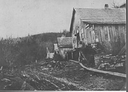
Boonford is a ghost town in Yancey County, North Carolina, and Mitchell County, North Carolina in the United States, located near present-day North Carolina Highway 80.
Boonford was named for Daniel Boone, as it was said he forded the North Toe River at the site. [2] The town's development was spurred on by the arrival of the Clinchfield Railroad in 1902, on its line to Johnson City, Tennessee. Nearly every structure in the town no longer exists. [3]
Boonford's U.S. Post Office opened on November 17, 1902, in Yancey County. [4] It was moved to Mitchell County on December 28, 1914, and closed on May 31, 1951. [5]
The town was home to a number of feldspar and mica mines. [6]
Allendale County is a county located in the U.S. state of South Carolina. As of the 2020 census, the population was 8,039, making it the least populous county in South Carolina. Its county seat is Allendale.
Yancey County is a county located in the U.S. state of North Carolina. As of the 2020 census, the population was 18,470. Its county seat is Burnsville.
Swain County is a county located on the far western border of the U.S. state of North Carolina. As of the 2020 census, the population was 14,117. Its county seat is Bryson City.
Mitchell County is a county located in the U.S. state of North Carolina. As of the 2020 census, the population was 14,903. Its county seat is Bakersville.
McDowell County is a county located in the U.S. state of North Carolina. As of the 2020 census, the population was 44,578. Its county seat is Marion.
Buncombe County is a county located in the U.S. state of North Carolina. It is classified within Western North Carolina. The 2020 census reported the population was 269,452, making it the 7th-most populous county in North Carolina. Its county seat is Asheville. Buncombe County is part of the Asheville, NC Metropolitan Statistical Area.
Wadesboro is a town and the county seat of Anson County, North Carolina, United States. The population was 5,008 at the 2020 census. The town was originally found in 1783 as New Town but changed by the North Carolina General Assembly to Wadesboro in 1787 to honor Colonel Thomas Wade, a native son, state legislator, and Revolutionary War commander of the Anson County Regiment.
Yanceyville is a town in and the county seat of Caswell County, North Carolina, United States. Located in the Piedmont Triad region of the state, the town had a population of 1,937 at the 2020 census.
Burnsville is a town that serves as the county seat of Yancey County, North Carolina, United States. Located in the Blue Ridge Mountains of western North Carolina, sits in the shadow of Mount Mitchell, the highest peak in the Eastern Continental United States. The population was 1,612 at the 2020 census.
Locke Craig, an American lawyer and Democratic politician, was the 53rd governor of the U.S. state of North Carolina, serving from 1913 until 1917.
Benjamin Williams was the 11th and 14th Governor of the U.S. state of North Carolina, from 1799 to 1802 and from 1807 to 1808. He was the first of two North Carolina Governors since the American Revolution to serve nonconsecutive terms.
Cornelius Harnett was an American Founding Father, politician, merchant, plantation owner, and slaveholder from Wilmington, North Carolina. He was a leading American Revolutionary statesman in the Cape Fear region, and a delegate for North Carolina in the Continental Congress from 1777 to 1779 where he signed the Articles of Confederation. Cornelius Harnett is the namesake of Harnett County, North Carolina.
The North Toe River is the headwaters of the Nolichucky River and a tributary in the French Broad River basin. From its source at Sugar Gap, between Bald Mountain and Sugar Mountain, it flows 73.6 miles (118.4 km) westerly through Avery, Mitchell, and Yancey counties.
The Wilmington District Brigade was an administrative division of the North Carolina militia during the American Revolutionary War (1776–1783). This unit was established by the North Carolina Provincial Congress on May 4, 1776, and disbanded at the end of the war.
The North Carolina Department of Commerce was formed in 1971 by the North Carolina State Government Reorganization Act. The department is headed by the Secretary of Commerce, who is appointed by the Governor of North Carolina. The Secretary is part of the Governor's Cabinet. The chief function of the department is to connect businesses with locations, workforce and infrastructure in North Carolina that businesses need to succeed. The department also connects local communities with grants and funding sources to attract new business to North Carolina. The department also staffs and receives policy guidance from: the North Carolina Board of Science, Technology, and Innovation; the NCWorks Commission; and the Rural Infrastructure Authority.
Ramseytown, formerly known as Ramsaytown and Ramsey Town Baptist Church, is an unincorporated community in far northern Yancey County, North Carolina, on the Cane River. Yancey County's Ramseytown Township derives its name from the settlement.
Sioux is an unincorporated community in far northern Yancey County, North Carolina, in the Ramseytown Township located alongside Big Creek, a tributary of the Cane River.