
South Dakota is a U.S. state in the North Central region of the United States. It is also part of the Great Plains. South Dakota is named after the Dakota Sioux Native American tribe, which comprises a large portion of the population with nine reservations currently in the state and has historically dominated the territory. South Dakota is the 17th largest by area, but the 5th least populous, and the 5th least densely populated of the 50 United States. As the southern part of the former Dakota Territory, South Dakota became a state on November 2, 1889, simultaneously with North Dakota. They are the 39th and 40th states admitted to the union; President Benjamin Harrison shuffled the statehood papers before signing them so that no one could tell which became a state first. Pierre is the state capital, and Sioux Falls, with a population of about 192,200, is South Dakota's most populous city.

Yancey County is a county located in the U.S. state of North Carolina. As of the 2020 census, the population was 18,470. Its county seat is Burnsville.

Mitchell County is a county located in the U.S. state of North Carolina. As of the 2020 census, the population was 14,903. Its county seat is Bakersville.

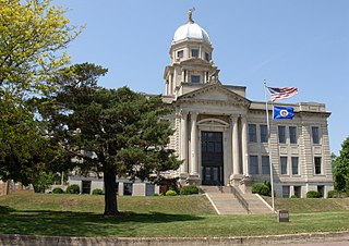
McDowell County is a county located in the U.S. state of North Carolina. As of the 2020 census, the population was 44,578. Its county seat is Marion.

Madison County is a county located in the U.S. state of North Carolina. As of the 2020 census, the population was 21,193. Its county seat is Marshall. Madison County is part of the Asheville, NC Metropolitan Statistical Area.
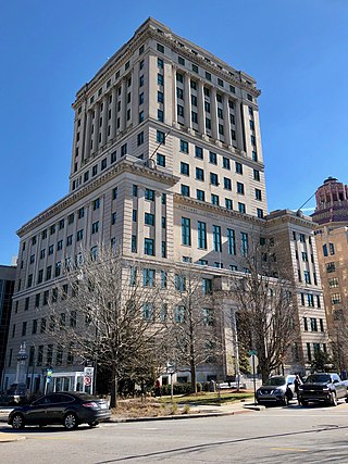
Buncombe County is a county located in the U.S. state of North Carolina. It is classified within Western North Carolina. The 2020 census reported the population was 269,452. Its county seat is Asheville. Buncombe County is part of the Asheville, NC Metropolitan Statistical Area.
Jackson County is a county in the U.S. state of Minnesota. As of the 2020 census, the population was 9,989. Its county seat is Jackson.

Yanceyville is a town in and the county seat of Caswell County, North Carolina, United States. Located in the Piedmont Triad region of the state, the town had a population of 1,937 at the 2020 census.

Salisbury is a city in the Piedmont region of North Carolina, United States; it has been the county seat of Rowan County since 1753 when its territory extended to the Mississippi River. Located 25 miles (40 km) northeast of Charlotte and within its metropolitan area, the town has attracted a growing population. The 2020 census shows 35,580 residents.

Burnsville is a town that serves as the county seat of Yancey County, North Carolina, United States. Located in the Blue Ridge Mountains of western North Carolina, sits in the shadow of Mount Mitchell, the highest peak in the Eastern Continental United States. The population was 1,612 at the 2020 census.

Bartlett Yancey was an American politician who was a U.S. congressman from North Carolina, United States, between 1813 and 1817. He was a member of the Democratic-Republican party.
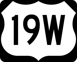
U.S. Route 19W (US 19W) traverses approximately 63 miles (101 km) from Cane River, North Carolina, to Bluff City, Tennessee.

USS Yancey (AKA-93/LKA-93) was an Andromeda-class attack cargo ship built by the Moore Dry Dock Company of Oakland, California for the United States Navy during World War II. The ship was named in honor of Yancey County, North Carolina.

North Carolina's 11th congressional district encompasses most of Western North Carolina. Since January 3, 2023, the district has been represented by Chuck Edwards.

U.S. Highway 19 (US 19) traverses 145 miles (233 km) across Western North Carolina; from the Georgia state line, at the community of Bellview, to Cane River, where US 19 splits into US 19E and US 19W, which take separate routes into Tennessee.

North Carolina Highway 80 (NC 80) is a primary state highway in the U.S. state of North Carolina. The highway connects the various mountain communities straddled along Buck Creek, South Toe River and North Toe River in Western North Carolina and serves as a direct route, via the Blue Ridge Parkway, to Mount Mitchell State Park.

This list includes properties and districts listed on the National Register of Historic Places in Yancey County, North Carolina. Click the "Map of all coordinates" link to the right to view a Google map of all properties and districts with latitude and longitude coordinates in the table below.
The Cane River is a 38.3-mile (61.6 km) river in Yancey County, North Carolina. It originates from the confluence of Beech Nursery Creek, off the western slope of Mount Mitchell, and Blue Sea Creek, off the northeastern slope of Blackstock Knob, in the Black Mountains. A tributary in the French Broad River basin, it flows northward to join the North Toe River, forming the Nolichucky River.

Ramseytown, formerly known as Ramsaytown and Ramsey Town Baptist Church, is an unincorporated community in far northern Yancey County, North Carolina, on the Cane River. Yancey County's Ramseytown Township derives its name from the settlement.

Boonford is a ghost town in Yancey County, North Carolina, and Mitchell County, North Carolina, located near present-day North Carolina Highway 80.


