
Blowing Rock is a town in Watauga and Caldwell counties in the U.S. state of North Carolina. The population was 1,397 at the 2021 census.

Lover's Leap, or Lovers' Leap, is a toponym given to a number of locations of varying height, usually isolated, with the risk of a fatal fall and the possibility of a deliberate jump. Legends of romantic tragedy are often associated with a Lover's Leap.
The geology of Shropshire is very diverse with a large number of periods being represented at outcrop. The bedrock consists principally of sedimentary rocks of Palaeozoic and Mesozoic age, surrounding restricted areas of Precambrian metasedimentary and metavolcanic rocks. The county hosts in its Quaternary deposits and landforms, a significant record of recent glaciation. The exploitation of the Coal Measures and other Carboniferous age strata in the Ironbridge area made it one of the birthplaces of the Industrial Revolution. There is also a large amount of mineral wealth in the county, including lead and baryte. Quarrying is still active, with limestone for cement manufacture and concrete aggregate, sandstone, greywacke and dolerite for road aggregate, and sand and gravel for aggregate and drainage filters. Groundwater is an equally important economic resource.
Tinker's Creek, in Cuyahoga, Summit and Portage counties, is the largest tributary of the Cuyahoga River, providing about a third of its flow into Lake Erie.

The Wildcat Hills are an escarpment between the North Platte River and Pumpkin Creek in the western Panhandle, in the state of Nebraska in the Great Plains region of the United States. Located in Banner, Morrill, and Scotts Bluff counties, the high tableland between the streams has been eroded by wind and water into a region of forested buttes, ridges and canyons that rise 150 to 300 m above the surrounding landscape.

The Linville Gorge Wilderness is the third largest wilderness area in North Carolina and one of only two wilderness gorges in the Southern United States. Maintained by the United States Forest Service, it comprises 11,786 acres (47.7 km2) around the Linville River, and is situated inside the Pisgah National Forest. The river is approximately 1,400 feet below the ridge, thus hiking in and out of the Gorge is challenging and enjoyable for those who like serious hiking. The plant and animal community is extremely diverse, with a dense hardwood/pine forest and a wide variety of smaller trees and other plants as well as bear, fox, raccoon, trout, grouse, wild turkey, vultures, owls, hawks, copperheads, and timber rattlesnakes.
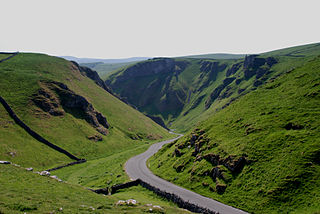
Winnats Pass is a hill pass and limestone gorge in the Peak District of Derbyshire, England. The name is a corruption of 'wind gates' due to the swirling winds through the pass. It lies west of the village of Castleton, in the National Trust's High Peak Estate and the High Peak borough of Derbyshire. The road winds through a cleft, surrounded by high limestone ridges. At the foot of the pass is the entrance to Speedwell Cavern, a karst cave accessed through a flooded lead mine, and which is a popular tourist attraction.
Granite outcrops of Western Australia are weathered landforms that occur throughout the state of Western Australia, composed primarily of the rock type granite. All recognised types of this landform can be observed, commonly as bornhardts, but also as inselbergs, castle koppies and nubbins. Rising abruptly from the surrounding landscape they create a variety of microhabitats for plants, and provide seasonal resources and refuge for a range of animals. These areas thus have rich biodiversity and many endemic species. They are significant locations that tie in with the Aboriginal and European cultural heritage of Western Australia.
A mountain-gap wind, gap wind or gap flow is a local wind blowing through a gap between mountains.
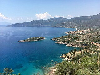
Kardamili is a town by the sea thirty-five kilometers southeast of Kalamata, Greece. It is the seat of the municipality of Lefktro in the region of Messenia on the Mani Peninsula.
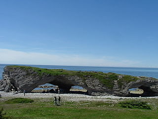
The Arches Provincial Park is a public park on the western coastline of Newfoundland and Labrador, Canada that features a photogenic rock formation.

The Roundtop Trail is an American hiking trail in Sevier County and Blount County sections of the Great Smoky Mountains National Park. The trail traverses the crest of Roundtop, a 3,077-foot (938 m) mountain that straddles the park's northern boundary. This trail, which passes through a thick forest of pine and oak and provides vistas of the valleys to the north and the mountains to the south, is one of the least-used trails in the park.
Caribou River Provincial Wilderness Park is a provincial park in extreme north-central Manitoba, Canada. It is the northernmost provincial park in Manitoba, and borders the southern Nunavut border.
Fresno City is a former settlement in Fresno County, California. It was located at the head of navigation on Fresno Slough 2 miles (3.2 km) northwest of Tranquillity, at an elevation of 164 feet. The city was named after the Spanish word for the Oregon Ash trees that commonly grew along the river banks.
The Roßtrappe is a 403-metre-high (1,322 ft) granite crag in the Harz mountains of central Germany.

The Bode Gorge is a 10 kilometres (6.2 mi) long ravine that forms part of the Bode valley between Treseburg and Thale in the Harz Mountains of central Germany. The German term, Bodetal, is also used in a wider sense to refer to the valleys of the Warme and Kalte Bode rivers that feed the River Bode.
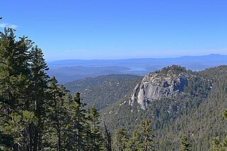
Suicide Rock is a granite outcrop near Idyllwild, California, which is popular with rock climbers. Over three hundred climbing routes have been described. It is located near Tahquitz Peak.

Dells of the Eau Claire County Park is in the north-central Wisconsin Town of Plover, east of the city of Wausau. It is divided in two by the Eau Claire River. The river flows through a rocky gorge to form cascades and waterfalls as it passes over and around weathered boulders, outcrops, and other formations. The depth of the river can vary depending on the time of the year. The park also has areas designated for camping, swimming, hiking, and picnicking.
Coy is an unincorporated community in western McDonald County, in the U.S. state of Missouri. The community is located about mid-way between Anderson and Tiff City along the south side of the Patterson Creek valley. Missouri Route 76 passes about three-quarters of a mile to the south.
Rani Dhunga, originally known as Sita Paila, is a huge rocky outcrop considered to be holy, in the Himalayas 6 km to the north-east of Pelling town, Sikkim, India, at an altitude of 2680m.

