
Mount Ayr is a town in Jackson Township, Newton County, in the U.S. state of Indiana. The population was 122 at the 2010 census.
Beals is a town in Washington County, Maine, United States, located on an island opposite Jonesport. The town was named after Manwarren Beal, an early settler. The population was 443 at the 2020 census.
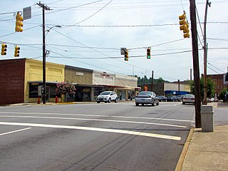
Taylorsville is a town in Alexander County, North Carolina, United States. The population was 2,098 at the 2010 census. It is the county seat of Alexander County.

White Lake is a town in Bladen County, North Carolina, United States. The population was 802 at the 2010 census, up from 529 in 2000.
Boardman is a town in Columbus County, North Carolina, United States. Per the 2020 census, the population was 166.

Bridgeton is a town in Craven County, North Carolina, United States. The population was 454 at the 2010 census. It is part of the New Bern, North Carolina Micropolitan Statistical Area.
Mesic is a town in Pamlico County, North Carolina, United States. The population was 220 at the 2010 census. It is part of the New Bern, North Carolina Micropolitan Statistical Area.

Fairplains is a census-designated place (CDP) in Wilkes County, North Carolina, United States. The population was 2,051 at the 2000 census. The community was named "fairplains" because it was located at the geographic point where the foothills of the Blue Ridge Mountains begin to level off to the gently rolling Piedmont region of central North Carolina.

Hays is a census-designated place (CDP) in Wilkes County, North Carolina, United States. The population was 1,595 at the 2020 census. North Wilkes High School, one of Wilkes County's four public high schools, is located in Hays.
Millers Creek is a census-designated place (CDP) in Wilkes County, North Carolina, United States. The population was 2,112 at the 2010 census. West Wilkes High School, one of the four public high schools in Wilkes County, is located in Millers Creek.

Moravian Falls is a census-designated place (CDP) in Wilkes County, North Carolina, United States. The population was 1,712 as of the 2020 census.

Mulberry is a census-designated place (CDP) in Wilkes County, North Carolina, United States. The population was 2,332 at the 2010 U.S. Census. The community was given its name by the first European pioneers to settle the area in the 1750s. These settlers called the region "Mulberry Fields", after the many mulberry trees in the area. Mulberry Creek, one of the largest streams in Wilkes County, takes its name from the community of Mulberry, and flows through the area.
Pleasant Hill is a census-designated place (CDP) in Wilkes County, North Carolina, United States. The population was 1,109 at the 2000 census.
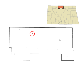
Westhope is a city in Bottineau County, North Dakota, United States. The population was 374 at the 2020 census. Westhope was founded in 1903 along a Great Northern Railway branch line that began in Rugby. The name was based on the slogan "Hope of the West," created by Great Northern officials to promote prosperity for the new town.

Hilda is a town in Barnwell County, South Carolina, United States. The population was 447 at the 2010 census..

Springfield is a town in Orangeburg County, South Carolina, United States. The population was 524 at the 2010 census.

Westmoreland is a town in Sumner County, Tennessee, United States, and is bordering southern Kentucky.The population was 2,093 at the 2000 census and 2,206 at the 2010 census. The town name was inspired by a wealthy lumberman from North Carolina, sharing the same name.

West Logan is a town along the Guyandotte River in Logan County, West Virginia, United States. The population was 400 at the 2020 census. For unknown reasons, some sources report West Logan to lay west of the county seat at Logan, attributing to this fact the name.

Bergen is a town in Marathon County, Wisconsin, United States. It is part of the Wausau, Wisconsin Metropolitan Statistical Area. The population was 740 at the 2020 census. The unincorporated community of Moon is located partially in the town.

Weddington is a suburban town in Union County, North Carolina, United States. The population was 9,459 at the 2010 census. It is a suburb in the Charlotte metropolitan area. The current mayor of Weddington is Jim Bell.

